I took a walk on Monday to look at work going on near the Wormleighton site I posted photos of a few weeks ago, this time taking to the footpaths to see bits not visible from the road. This is the northern end of the cutting at Wormleighton and the crossing of the Oxford Canal, see:
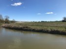
The first photo is taken from the canal towpath and shows a large heap of spoil in the distance. HS2 will run from this heap along the far bank of the canal before crossing it off to the right.
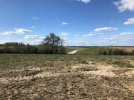
Walking back up from the canal to the village reveals the view in the second photo, taken looking down towards the canal. The cutting you can see in the middle distance is through the final hump of land at the north end of the cutting shown in the section drawing. This is possibly the only extant bit of HS2 formation and is a heave monitoring site according to the signs on the construction compound.
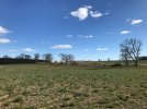
If you look at the plan and section the amount of excavation neccessary becomes apparent. Where I'm standing will become cutting and looking up the hill - see photo three - the cutting becomes deeper. Given that there are four tracks for maintenance loops further up this is going to be Tring-like when completed.
I attracted the attention of a security guard who took a photo of me shortly after taking the latter two. Were I paranoid, I might think my image was being run through facial recognition software right now and I should expect a knock on the door. He was probably just worried about people casing the site to nick stuff.

I should add that I was on a public footpath.