• Our booking engine at tickets.railforums.co.uk (powered by TrainSplit) helps support the running of the forum with every ticket purchase! Find out more and ask any questions/give us feedback in this thread!

Woodhead Ventilation Shafts

Status
Not open for further replies.

tbwbear

Member
Joined
28 Nov 2017
Messages
263
I walked from Woodhead over the top to Dunford Bridge today.

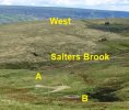
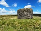
The OS map shows 3 vent shafts -

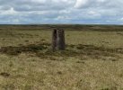
the first one ( from the west) looked to be intact - it was a normal brick tower job. I am assuming that was from the 1845 / 53 bores.

The easterly one was just a flat brick structure sealed over - looking online I think this one used to be a full brick shaft and it used to have a picture of a class 76 on it, but was demolished and sealed several years ago - was this the 54 vent shaft ?

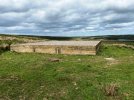
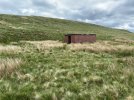
The middle one confused me - there was a building ( like a bothy hut) but nothing else. Has that one been sealed too ?

how many shafts were there in the first place and what is their status now ?

I understood the original tunnels had 4 - the ‘54 tunnel had one - what are the 3 on the OS map today

be interested to know....
 
Sponsor Post - registered members do not see these adverts; click here to register, or click here to log in
R

RailUK Forums

Mcr Warrior

Veteran Member
Joined
8 Jan 2009
Messages
11,814
Believe there were originally five construction shafts with respect to the original 1840s first tunnel. The second tunnel made use of the same ventilation.

Presume that some must have historically subsequently been capped / covered over, with the remainder becoming ventilation / air shafts, including the one built for the new 1950s tunnel.

The flat topped "bothy building" that you refer to, if it's the one near Wike Head, and about half way along above the course of the tunnel, may be the one that I understand was once used as a storage place for explosives used during tunnel construction.

Anyone else able to confirm/further clarify?
 

tbwbear

Member
Joined
28 Nov 2017
Messages
263
Thanks for this.

I have managed to do a bit more research and this is what I now think....(open to challenges... though)

The National Library of Scotland OS Map for 1947 shows 6 shafts for the original tunnel(s). 3 each side of Salter's Brook.

I think you are correct about 5 construction shafts - so was one of these added later- I wonder ?

( I am wondering whether it was one of the first two westerly ones - as what is actually the third on the map is often referenced as No 2 and the most easterly as No 5)

Going from the west, the first one is quite close to the western portal, the second is in the area of the quarry, the third is just to the west of Salter's Brook. After Salter's Brook there is fourth one at Wike Head, then there are two more before Dunford Bridge.

Interestingly, the 3 west of Salter's Brook are called "Air Shafts" on the map, the 3 to the east are called "Ventilators"

The modern OS Map shows "Air Shafts" at only positions 3, 4 and 6 of those above. In other words, 1,2 and 5 are missing.

The 1954 tunnel had a new air shaft next to the original one at Wike Head and it was also fed from the most easterly one (6) I think.


The photographs below show what I found last week,

At the western location (3) = a tower, seemingly in its original form.

At the central location (4 /Wike Head) = a pile of bricks over a sealed shaft which I think is for the original tunnel (B) but nothing really visible in the position of the, presumably sealed, 1950s shaft (A). I have seen photographs of this online. It used to be an square structure I think.

At the eastern location (6) = a square brick type structure over the sealed shaft. This one, I believe, used to be the one where the old tower had a painting of a Class 76 on it.

The hut at Wike Head for the explosives. For the 1950s tunnel ?

One of the little trig points that follow the line of the tunnel at intervals. These look as if they were built for the 1950s tunnel ?

I think this is correct - but am certainly open to being corrected.....
 

Attachments

  • Central.JPG
    Central.JPG
    66.8 KB · Views: 55
  • East.JPG
    East.JPG
    44.7 KB · Views: 53
  • Hut.JPG
    Hut.JPG
    47.7 KB · Views: 55
  • Trig Point.JPG
    Trig Point.JPG
    41.5 KB · Views: 55
  • West.JPG
    West.JPG
    48.5 KB · Views: 54
Last edited:

Mcr Warrior

Veteran Member
Joined
8 Jan 2009
Messages
11,814
Good sleuthing and photos.

I concur that the first (no longer there or capped / filled in?) air shaft was up above the Western portal of the tunnel on the hillside roughly between Audernshaw Clough and Ironbower Moss. Approximate map reference SE116000.

The second (also no longer extant air shaft) would have been at Greystone Edge Quarry. Map reference SE123004.

The third (the high sided circular walled one which is very much still there) can be found approaching Upper Head Dike, just above Salters Brook, which is one of the main sources of the River Etherow. Map reference SE129008.

The fourth (the square sided one) is on Wike Edge. Map reference SE135011.

And the one approaching Dunford Bridge (circular walled air shaft with a mural of electric loco 76001 painted on it) is up on Upper Grip Hill at map reference SE147017.

Think the other "missing" shaft / ventilator must have been in between the last two in the Dearden Moss area at map reference SE141014. Just seems to be just a pile of rocks at this location now which will have had to have come up from somewhere.

N.B. The Victorian era gunpowder / explosives store at Woodhead Tunnel had an arched doorway but I don't have a precise map location for it. Concur it's not the building on Wike Edge.

Understand that there was just one new construction shaft used in connection with the new 20th century tunnel, apparently 2610 yards from the Woodhead end, which I make to be roughly in the Wike area. Understand that some gelignite was indeed used in the construction of this 1950's tunnel so maybe the utilitarian-looking flat topped building was also used for storing explosives after all.

And finally, the various concrete posts along the line of the 20th century tunnel were indeed used to support theodolites used during surveying work.

(They are slightly differently shaped from the more traditional OS trig points mostly constructed across the country in the 1930s/1940s, and don't seem to be weathering quite as well).
 

Mcr Warrior

Veteran Member
Joined
8 Jan 2009
Messages
11,814
Looking at various photos in the chapter on the New Woodhead Tunnel which appear in "Woodhead - The Electric Railway" (2001) by E.M. Johnson (Foxline Ltd) there is a circular tower to be seen, located high up on the hillside above the line of the original 1840's tunnels at the Western end.

Presumably this was the first ventilation shaft / "observation tower" (which nowadays is no longer standing) so possibly it got demolished quite soon after the Victorian era tunnels were closed to railway traffic in the mid 1950s.260px-Woodhead_Tunnel_west_portal_during_construction_of_new_tunnel_geograph-4048562-by-Ben-Br...jpg

Photo of Woodhead tunnel, c. 1953 (Source: Wikipedia).
 

tbwbear

Member
Joined
28 Nov 2017
Messages
263
Presumably this was the first ventilation shaft / "observation tower" (which nowadays is no longer standing) so possibly it got demolished quite soon after the Victorian era tunnels were closed to railway traffic in the mid 1950s.

Yes,

The OS map for 1900 viewable on National Library of Scotland certainly has the words "air shaft / observation tower" at the point that corresponds to the tower in the photograph. And the next air shaft on the map, the one at Greystone edge quarry, also had an observation tower.

But I found this reference on line...


It gives the exact positions of the 5 air shafts of the original tunnels exactly as in your post above.

But it lists the first one as being at Greystone edge quarry.

The rough postions are 1) 22%, 2) 38%, 3) 50%, 4) 64%, and 5) 78% of the distance from Woodhead to Dunford.

The 1954 tunnel used a new shaft next to 3) and an internal link to the original 5).

In the very detailed (and I believe accurate) account in that link, there is no mention of an airshaft at the point where the observation tower in the picture is.

My best theory now is - there never was and there is an error on the map. It was an observation tower for the tunnel, but had no airshaft.

It seems too close to the Woodhead portal to have been any use as a shaft anyway.

Happy to be proved wrong.
 
Last edited:

Mcr Warrior

Veteran Member
Joined
8 Jan 2009
Messages
11,814
My best theory now is - there never was and there is an error on the map. It was an observation tower for the tunnel, but had no airshaft.

It seems too close to the Woodhead portal to have been any use as a shaft anyway.
I'm inclined to agree. Good interpretation of the facts!

Which begs the question, what was the "observation tower" (if that's what it was) up on the hillside above the Woodhead tunnel portals used for observing, exactly?
 

tbwbear

Member
Joined
28 Nov 2017
Messages
263
I'm inclined to agree. Good interpretation!

Which begs the question, what was the "observation tower" up above the Woodhead tunnel portals used for observing, exactly?
I think it is the line of the tunnel isn't it ?

The workers at the portal can see the first tower, the first tower can see the second, etc.. and they all are built on the line of the intended tunnel.

That information is then used to compare with the internal heading to make sure they are going in the right direction.

Or something along those lines ?


The 1954 tunnellers used the little trig points for a similar purpose, although presumably they benefited from aerial photography and new methods too.
 

Mcr Warrior

Veteran Member
Joined
8 Jan 2009
Messages
11,814
I think it is the line of the tunnel isn't it ?

The workers at the portal can see the first tower, the first tower can see the second, etc.. and they all are built on the line of the intended tunnel.

That information is then used to compare with the internal heading to make sure they are going in the right direction.
So they would be like outsized surveyors' marker posts?

Entirely plausible as I reckon the tunnel-related (above surface) workings in the Greystone Quarry area would be just about observable from the (up above the) Woodhead tunnel "observation tower" given that the high moorland flattens somewhat beyond there.

Still seems slightly surprising that the Victorian era observation tower (if indeed it was) then survived until at least the 1950s.
 
Status
Not open for further replies.

Top