• Our booking engine at tickets.railforums.co.uk (powered by TrainSplit) helps support the running of the forum with every ticket purchase! Find out more and ask any questions/give us feedback in this thread!

Yorkshire's railways - a map

Status
Not open for further replies.

YorksLad12

Established Member
Joined
5 Feb 2020
Messages
1,888
Location
Leeds
Arthington needs a N to W curve adding.

Shipley station is shown on the 6in map of 1852 just North of Valley Road bridge, some way south of the present station; also, is there any way of showing that the present triangular arrangement of platforms only dates from 1979?
Arthington: yes, there was a curve. Did regular, timetabled passenger services run over it? They would have missed out Arthington if so (unless they reversed). I'll use timetableworld.com to see if there were , for example, any Skipton-Harrogate services.

Shipley: Wikipedia says
The Ordnance Survey map of Shipley in 1852 (surveyed between 1847 and 1850) shows the station some 500 m south of the present one, where Valley Road crosses the line to Bradford. However, an article in the Bradford and Wakefield Observer in February 1849 describes the station in its present position. It is not clear if it was moved in its first few years or there is an error on the map.
There was a goods yard at that point, although that might have been on the site of the former station. More to investigate here!

And: no, not really as the station is in that state now and open. If one set of platforms was removed it would be easy to show that they had been there but redevelopment of a station to add more can't be done (see Leeds).
 
Sponsor Post - registered members do not see these adverts; click here to register, or click here to log in
R

RailUK Forums

unslet

Member
Joined
5 Apr 2013
Messages
58
Location
Leeds
Brilliant job,I admire your patience. Perhaps your next county should be Rutland.

The station just north of Scarborough was Cloughton,not Claughton.
 

30907

Veteran Member
Joined
30 Sep 2012
Messages
18,006
Location
Airedale
Arthington: yes, there was a curve. Did regular, timetabled passenger services run over it? They would have missed out Arthington if so (unless they reversed). I'll use timetableworld.com to see if there were , for example, any Skipton-Harrogate services.

Shipley: Wikipedia says

There was a goods yard at that point, although that might have been on the site of the former station. More to investigate here!

And: no, not really as the station is in that state now and open. If one set of platforms was removed it would be easy to show that they had been there but redevelopment of a station to add more can't be done (see Leeds).
Arthington: regular longer distance seasonal services used the curve, not sure about local trains.
Shipley: The Goods Yard is Crossley Evans' scrapyard now. I tend to trust the OS cartographers* - perhaps the original Shipley station didn't last long and was replaced by one as described in the (3rd hand reference to the) local paper between the OS survey and publication.
*at least for locations - they are not always up to date.
 

Pit_buzzer

Member
Joined
11 Oct 2020
Messages
238
Location
Bentley
An excellent piece of work, one observation from me regarding a 2nd Sprotbrough appearing between Doncaster and Conisbrough, I think that one should be Warmsworth and was on the line from Doncaster york road to rossington and which never actually opened to traffic
 
Last edited:

YorksLad12

Established Member
Joined
5 Feb 2020
Messages
1,888
Location
Leeds
Arthington: regular longer distance seasonal services used the curve, not sure about local trains.
Shipley: The Goods Yard is Crossley Evans' scrapyard now. I tend to trust the OS cartographers* - perhaps the original Shipley station didn't last long and was replaced by one as described in the (3rd hand reference to the) local paper between the OS survey and publication.
*at least for locations - they are not always up to date.
If the curve carried passenger traffic it goes in. And will do, in the next version.

Shipley is one of those where we're referring to secondary sources referring to secordary sources in order to compile... yet another secondary source. I'm inclined to believe the cartographers as well but another source wouldn't go amiss. While it would help, a photograph - perhaps a selfie from an enthusiast on a platform - is asking too much!

An excellent piece of work, one observation from me regarding a 2nd Sprotbrough appearing between Doncaster and Conisbrough, I think that one should be Warmsworth and was on the line from Doncaster york road to rossington and which never actually opened to traffic
Thanks. No - there were two Sprotboroughs, one on the South Yorkshire and one on the Hull & Barnsley. Warmsworth never opened to passengers, although it does appear on the RCH maps which is why I added the rider in the Notes about stations that were built but which never opened.
Brilliant job,I admire your patience. Perhaps your next county should be Rutland.

The station just north of Scarborough was Cloughton,not Claughton.
Quite so. Claughton is in L****shire. Corrected.
 

YorksLad12

Established Member
Joined
5 Feb 2020
Messages
1,888
Location
Leeds
The Nidd Valley and Derwent Valley lines appear tp be missing ?
Both are Light Railways, which I excluded (see Notes & Queries for the scope of the map). The Nidd Valley Railway from Harrogate to Pately Bridge is.
 

mike57

Established Member
Joined
13 Mar 2015
Messages
1,658
Location
East coast of Yorkshire
Excellent work, makes it easy to understand the relationship of our local lines. One minor addition:

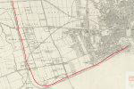
The Hull - Bridlington line ran into Hull Manor Street for a couple of years after opening until Paragon station was opened.

Old maps show the route, 1618929423419.png1618929423419.png
 

YorksLad12

Established Member
Joined
5 Feb 2020
Messages
1,888
Location
Leeds
Excellent work, makes it easy to understand the relationship of our local lines. One minor addition:

The Hull - Bridlington line ran into Hull Manor Street for a couple of years after opening until Paragon station was opened.

Old maps show the route, View attachment 94786View attachment 94786
Ta, and ta. Something else I wasn't sure of (this will be interesting to add...). I also had Paragon's opening date wrong.
 

yorkguy

Member
Joined
15 Sep 2013
Messages
66
I've no local knowledge, but old OS maps show the Settrington to Amotherby line crossing over the Malton to Scarborough line, with only a single chord linking Settrington to Malton. The question becomes - did trains travelling between Settrington and Amotherby call at Malton, which would require a double reversal?
There were never any local passenger services between Settrington and Amotherby. The only through trains on this route were goods services carrying stone from Burdale Quarries, north to Teesside, and occasional summer Saturday services in the 50/60s from NE England to Butlins at Filey. All of these would cross directly over the Scarborough line, missing Malton station.
 

Spartacus

Established Member
Joined
25 Aug 2009
Messages
2,922
One I've noticed is the placement of the Birstall branch and Howden Clough line, the Howden Clough line being further north than the Birstall line rather than vice versa. The whole area looks a bit off, though with no obvious errors beyond the very complicated changes that occured over the years. Would it held if the section between Batley and Dewsbury was mostly two vertical lines?
 

YorksLad12

Established Member
Joined
5 Feb 2020
Messages
1,888
Location
Leeds
One I've noticed is the placement of the Birstall branch and Howden Clough line, the Howden Clough line being further north than the Birstall line rather than vice versa. The whole area looks a bit off, though with no obvious errors beyond the very complicated changes that occured over the years. Would it held if the section between Batley and Dewsbury was mostly two vertical lines?
Fair point, and something I touched on at the start. If it was just dots and names it would be easy; but when you add in the labels the space doesn't half disappear in certain sections, Spenborough being one of them. The line from Batley to Dewsbury is mostly north-south; the line from Dewsbury Central swept underneath it to Batley Carr then crossed back to reach Batley before heading north west.

It bugs me as well slightly; I have tried a few times to fix it but there just isn't the room. My next 'trick' when I get a moment will be to swing the line out the 'wrong' way at Cottingley, which would give me more scope to make the next part a vertical down to Dewsbury. If that doesn't work I'll give up!
 

alistairlees

Established Member
Joined
29 Dec 2016
Messages
3,737
As ever, a great piece of work. A couple of minor suggestions: Redcar opened in a different location as a terminus in 1846, and was only resited to the current location in 1861. Guisborough was a terminus, not a through station (unless there two?). Keep up the good work!
 

Kingspanner

Member
Joined
17 Jul 2019
Messages
325
Location
Dinsdale
Excellent work. That's the rest of my evening sorted.
Have you thought of protecting the map in case someone tries to monetise it?
And may I enquire after Eaglescliffe which should be between Yarm and Thornaby? It is a mapmaking nuisance being north of the Tees but so close to two stations you are including.
 

YorksLad12

Established Member
Joined
5 Feb 2020
Messages
1,888
Location
Leeds
As ever, a great piece of work. A couple of minor suggestions: Redcar opened in a different location as a terminus in 1846, and was only resited to the current location in 1861. Guisborough was a terminus, not a through station (unless there two?). Keep up the good work!
Ta. I will check on those two - the next version is almost here so best I do it now...

Excellent work. That's the rest of my evening sorted.
Have you thought of protecting the map in case someone tries to monetise it?
And may I enquire after Eaglescliffe which should be between Yarm and Thornaby? It is a mapmaking nuisance being north of the Tees but so close to two stations you are including.
Ta too. Eaglescliffe is north (well, west) of the Tees in County Durham, so will get added as a not-in-Yorkshire station when I do those, probably.

I added a Creative Commons bit at the foot of the Notes: CC BY-SA which means you can share it (fair enough) but not for profit, and with attribution. To be honest I might have written that down wrongly but it'll be correct for the first edition ;)
 

YorksLad12

Established Member
Joined
5 Feb 2020
Messages
1,888
Location
Leeds
Version 0.27 attached!

I have, as far as I can tell:
  • corrected any trypos.
  • put in additional dots for Bingley, Shipley, Redcar. and Berry Brow for the earlier stations I'd missed out.
  • redrew Guisborough, and Scalby's connection to Scarborough.
  • redrew the bits around Batley to make them more geographically correct (Batley Carr is still on the wrong side though - sorry).
  • added in the stations such as Sherburn-in-Elmet that I'd missed out through rushing and not double-checking.
  • added in the Selby to Goole line, which only @thewiltog spotted I'd missed (even I hadn't).
  • added in Wentworth, which I only discovered I'd missed out by accident because I forgot Warmsworth was what I was looking up yesterday on Wikipedia (shame on you all).
  • added in the Creative Commons licence symbols for those who were worried for me.
Brighouse: turns out we're both right on "for Bradford" and "for Rastrick", just at different times. Not sure when it became just "Brighouse" though.

Shipley: I did think about adding a label to each set of platforms as they opened but there just isn't the space. I was intending on adding some specific station notes in the Notes section anyway, so did that here. I ought also to add an asterisk and something in the Key to point people to the Notes for those stations with notes.

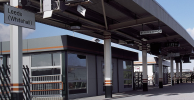
Leeds Whitehall: I think Wikipedia is wrong on this one. I remember is as being Whitehall *platform*, even though it was a modular, one-platform station design that Railtrack was going to adopt for future station builds (it didn't). I don't think it had its own station code. I'm not even sure it had pedestrian access, just the shuttle service to Leeds Station.

There's a bit more tidying-up to do on the dot/label spacing and lines, how they curve (or not) and how they don't quite join other lines properly before I get to First Edition status. So by all means, if you see anything else wrong, sing out and I'll either change it or argue about it :lol:
 

Attachments

  • Yorkshire Stations 0.27.pdf
    397.7 KB · Views: 44

js517

Member
Joined
4 Sep 2018
Messages
159
Location
Cragg Vale, West Yorkshire
Very impressive. You're missing Walsden - I don't think its been ceded to the dark side has it?

Did passenger services ever run on the section of the Selby-Goole line that starts at Thorpe Gates (see map here)? It isn't on your map.
 
Last edited:

eastwestdivide

Established Member
Joined
17 Aug 2009
Messages
2,548
Location
S Yorks, usually
In the Swinton area, there is a curve missing linking the line from Bolton on Dearne to the Mexborough direction. Was used by the long-distance precursors of the crosscountry route, running through the Sheffield area mostly via the GC routes (reverse at Sheff Victoria). So coming south, they would pass through Bolton on Dearne, turn left towards Mexborough (but not into it), then immediately sharp right on the curve that you do show, to go south via Swinton Central and Rotherham Central and the GC to Sheffield Vic.
Visible on this NLS map:
and remains still visible from the train, also on google aerial where there's a puddle under the A6023 bridge:
 

urbophile

Established Member
Joined
26 Nov 2015
Messages
2,073
Location
Liverpool
You've got Bell Busk as closing in 1880. It might have, then re-opened, but it was still hanging on in the 1950s... it would be the late 1950s or very early 60s that it finally closed to passengers.
 

alistairlees

Established Member
Joined
29 Dec 2016
Messages
3,737
Great stuff. I just noticed the connection between Yarm and Thornaby is the wrong way round
 

YorksLad12

Established Member
Joined
5 Feb 2020
Messages
1,888
Location
Leeds
Very impressive. You're missing Walsden - I don't think its been ceded to the dark side has it?

Did passenger services ever run on the section of the Selby-Goole line that starts at Thorpe Gates (see map here)? It isn't on your map.
Walsden wasn't in Yorkshire, it became part of West Yorkshire on 1 April 1974 which puts it out of scope. I did add Selby to Goole (three stations) in the revision I posted today.

In the Swinton area, there is a curve missing linking the line from Bolton on Dearne to the Mexborough direction. Was used by the long-distance precursors of the crosscountry route, running through the Sheffield area mostly via the GC routes (reverse at Sheff Victoria). So coming south, they would pass through Bolton on Dearne, turn left towards Mexborough (but not into it), then immediately sharp right on the curve that you do show, to go south via Swinton Central and Rotherham Central and the GC to Sheffield Vic.
Visible on this NLS map:
and remains still visible from the train, also on google aerial where there's a puddle under the A6023 bridge:
Ugh. That map's a mess of lines! I was going to say it's not on the RCH maps but actually... one small addition to follow. Thanks.

Cawood and Wistow Light Railway is missing. NER>LNER>BR most of its life.
True, but I did say I hadn't included any of the light railways (I count three; this one, Derwent Valley and Nidd Valley). Perhaps I should open a poll...?

You've got Bell Busk as closing in 1880. It might have, then re-opened, but it was still hanging on in the 1950s... it would be the late 1950s or very early 60s that it finally closed to passengers.
Good spot; 4 May 1959. I can't even say it was a copy & paste error from Hellifield further along, as I would have done the label for Bell Busk first. Hellfield is also going to need changing so that the first station is before the junction.

Dont pknow if youve seen this picture, but it clearly shows 'Way Out' so had pedestrian access at least. Good work with the map
View attachment 94895
Pedantically: it just says Way Out, and the sign below has what looks like a bus symbol on it. Given the area where the access road came out I'm not sure I'd like to have used it as a pedestrian! I went there once, for the opening event, and can't remember much about it. I do have some papers in the bottom of a box but remain convinced it was a temporary platform that happened to look like a downmarket version of Wakefield Westgate from the 1980s.

Great stuff. I just noticed the connection between Yarm and Thornaby is the wrong way round
How so? It branches north of Yarm and goes to either Stockton or Thornaby. Might need to add a curve between Thornaby and the line to Stockton though.
 
Last edited:

alistairlees

Established Member
Joined
29 Dec 2016
Messages
3,737
How so? It branches north of Yarm and goes to either Stockton or Thornaby. Might need to add a curve between Thornaby and the line to Stockton though.
I hadn’t appreciated that was the line to Stockton. If so, then there needs to be the line curving in from Darlington before then. Both junctions are north of the Tees though. The railway lines and the Tees are quite intertwined at this point.

Cliffe Common should have an “e” too I think?
 

YorksLad12

Established Member
Joined
5 Feb 2020
Messages
1,888
Location
Leeds
I hadn’t appreciated that was the line to Stockton. If so, then there needs to be the line curving in from Darlington before then. Both junctions are north of the Tees though. The railway lines and the Tees are quite intertwined at this point.

Cliffe Common should have an “e” too I think?
Yes, and will check (also under Hemingbrough). While trying to understand what you meant I realised that part of the line between Yarm and Thornaby is out of county. I'll have to redraw that section to make it clearer... somehow.

Yes I saw that, but the part of it from Thorpe Gates is missing.
Ah. Interesting. That piece of railway hasn't shown up on anything else I've looked at. Wikipedia says that the next stations on from Barlow were Selby (northwards) or Drax Hales (southwards), and there's no station at Thorpe Gates so I'm going with "no", unless evidence arises elsewhere. Might make some passive provision for it though, just to be safe (as I did with the light railways in case there was a great uprising for inclusion).
 

alistairlees

Established Member
Joined
29 Dec 2016
Messages
3,737
Before I forget, Sherburn-in-Elmet needs moving south of the junction. Apologies for all the niggly points!
 

Welshman

Established Member
Joined
11 Mar 2010
Messages
3,019
Version 0.27 attached!


Brighouse: turns out we're both right on "for Bradford" and "for Rastrick", just at different times. Not sure when it became just "Brighouse" though.
Brighouse for Rastrict closed in 1970 and re-opened as Brighouse in 2000.
 
Status
Not open for further replies.

Top