While the Medway Towns absolutely could do with them, the steep valley sides in Chatham (and to a lesser extent Strood) might limit the scope of where they operate. If it's possible though to have a system go south towards Walderslade and Lordswood to the south, plus St Marys Island to the North, those areas need better connectivity.
Here's my full idea. It's quite long so hesitated to post the 'detailed ' version.
Phase 1
Phase 1 is intended as a fast-to-implement route with high speeds to compete with blue bell hill or other routes for road drivers between Maidstone and Medway. It also gives fast connection to Chatham Docks and links to existing major stations at Strood and Gillingham in north, and uses the maidstone town centre dual carriageway loop for a wide catchment in the south. P&R could be added at Aylesford and where the railway passes under the M2.
Phase 1 key route is the existing railway from Strood to Maidstone via Snodland. That takes 24 minutes currently and has spare capacity. In future perhaps some passing loops at stations could be added to avoid less popular stations, noting some trains on this route go all the way to st pancras
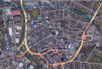
Phase 2: Maidstone end would be a loop around the town centre. Maidstone west station to be slightly north (or new tram-only platforms connecting to existing station), between A20 and Buckland Road. Note this triangle of land also bounded by st peter's street could be redeveloped for mixed uses, as well as other ground-level car parks nearby, to help fund the system. The major roads around the town centre cut it off from the other areas. Radial bus routes into maidstone from the south and east would be able to connect to the new tram-train route without entering the centre itself. The line from Maidstone East also appears lightly-used enough to allow trams to run there before reconnecting near Maidstone Barracks.
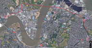
3. From Strood, there should be a station somewhere in Medway City Estate. Keeping on periphery reduces the time penalty from going deeper into it. Obviously some trade off there.
a. Medway tunnel looks wide and tall enough to accomodate overhead wires and avoid need to battery-hybrid trams.
b. 3 stations at near Chatham docks are actually ~600m spaced, with is a good distance from a tram route. Note I am not proposing for it to go into Chatham itself. That is because this route is targeting slightly longer-distance travellers so speed is of the essence to compete with cars, and sticking to mostly dual carriageway reduces cost. There's nothing to stop this in future.
c. From Pier road there is a former railway alignment (some still with single track sections) parallel to Rosebery road which could be used to connect to Gillingham station. Admittedly that is pretty overgrown with trees but if there were enough objections then maybe it could be a (costly) cut and cover with new pedestrian/cycle path above the tram route.
d. Note the land to north and east of the existing station is mostly carpark, perfect for development and gives some choice on tram route to the station (or if a loop is needed to avoid need for double-ended trams).
e. That is the end of Phase 1! There are connections to existing railway at Strood and Gillingham. I don't think there is capacity for tram-trains to run between Strood and Gillingham via Rochester and Chatham.
(as an aside, I love the idea of a cable car from Rochester station to the southern end of Medway City estate, which could be redeveloped along the southern riverfront while keeping the industrial businesses in the middle. There could be a 3rd station/stop in The Historic Dockyard. This kind of obstacle with existing quality rail transport is the perfect situation for a cable car to be successful, serving tourists, students, and commuters. Anyway, back to the trams!)
Phase 2
Phase 2 is basically the P&R loop (for M2) making very little use of existing railway alignment. Its purpose to reduce the number of private vehicles entering into the town centres, and should be built with transit-oriented-development in mind, particularly making use of existing car parks. The eastern section (via gillingham business park) is much more straightforward than the Western (blue bell to rochester) end. An alternative could be following the A2 straight through the towncentres, but that does less to keep drivers from driving into Medway and is more duplicative of existing railway. A2 could either be a future phase or a well-connected bus route.
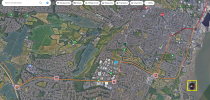
1. Phase 2 either starts at Gillingham station if there is capacity to run part-way to Rainham on existing rail alignment (noting some london services terminate at gillingham). If not then it would branch off from Phase 1 at the Pier Road Asda and follow the dual carriage way around to a station near corner of Yokosuka way and beechings way.
a. station near Gillingham business park, which is big enough that could even warrant have 2 stations at either end!
b. then on intermediate station before serving a P&R off the M2.
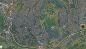
2. The next section follows the M2 to Blue bell hill, where there would be another P&R. The M2 median is wide enough to support an elevated bit of track, but I don't know if that would be any cheaper than cutting down some trees, and an intermediate stop at Lordswood would also be useful. Same logic for the P&R in Blue Bell Hill on south side of M2 - going over/under the motorway twice might be more cost than benefit vs staying on north side.
3. The route then follows the A229 into Rochester town centre. A portion of this could be split directionally with St williams way (see arrows below), or just one of those given over more fully to the tram priority (maybe access only?). THere are some greenfields and highway verges to help.
a. one stop at southern end of rochester high street, and another near the existing station. Note the surface-level car parks should be removed given the P&R opportunities, this allows for transport-oriented development and improves speed + competitiveness of the tram route.
b. The line shows a crossing on the historic rochester bridge. Perhaps that isn't feasible, in which case a new bridge would be needed. This is a major road bottleneck and I would personally have no misgivings of handing the capacity over to public transport. Tram route could be shared with bus priority lanes. Voters may disagree.