I've been meaning to come back to this thread for a while now with some more information. This is a long post but it's split into three separate parts:
1) Wintersett
2) Allerton Bywater
3) Allerton Main / Primrose Hill / Bowers Row Opencast
=======
Wintersett
=======
A little bit more digging (no pun intended) into Wintersett, with a rough timeline:
One thing I noticed when looking at this 1965 Ordnance Survey of the Wintersett area -
https://maps.nls.uk/view/189182592 - is the triangular layout from Nostell (North and South junctions) which joined at Wintersett Jn and continued as the Barnsley Coal Railway (later GC) line to Stairfoot, which closed in 1961. The Wikipedia page for the
Barnsley Coal Railway includes an RCH junction diagram for the area.
RailMapOnline shows the later sidings at Wintersett occupying land that would have been inside the triangle, with the entry and exit from the sidings being in the vicinity of Nostell North and South Jns.
One source I didn't check before are working timetables. Wintersett pops up in the 1983 YH WTT as the origin for a 7D56 09:15 MGR to Immingham NCB terminal, running via Applehurst Jn and Stainforth & Hatfield. The YJ timetable, which includes the Doncaster to Leeds line, shows Wintersett as a location in the Oct 1984 WTT. No trains are shown to the location, although that doesn't mean much when local MGR services would be planned weekly. It doesn't appear in the 1986 or 1989 timetables as a location on the route, which could be taken as an indication it was no longer active.
Wintersett timeline, based on available info:
1965: Ordnance Survey map shows triangular junction still in place (Nostell North and South Jns to Wintersett Jn) which had closed in 1961. No indication of sidings at Wintersett at this time, apart from up and down refuge sidings at Nostell North mentioned here -
https://britishrailways1960.co.uk/ners41/
1974: Anglers opencast site begins operation; sidings at Wintersett disposal point probably opened around the same time. It seems unlikely that "one of the deepest opencast mines in Europe" would open without accompanying rail loading facilities. Wintersett appears in the 1977 Baker Atlas as a coal loading point.
1980: Overhead bunker installed at Wintersett.
1982: Anglers opencast site closes. Wintersett disposal point may have survived for a few years longer to serve other opencast sites in the area.
1983: Appears in October 1983 WTT as origin of a train to Immingham NCB Coal export terminal
1984: Shown as a location in the October 1984 WTT.
1986: Not included as a location in the May 1986 WTT
1988: Wintersett closes "about 1988" according to
Merry Go Round: On the Rails, although its complete absence from both the 1984 Bakers Atlas and the 1988 Quail map suggests it may have closed earlier.
1989: Not included as a location in the May 1989 WTT.
1992: Wintersett disposal point reopens in early 90s and reappears in 1992 Baker Atlas. Photos of coal trains from Wintersett in 1993 and 1995.
1996: Baker Atlas indicates the sidings are in use by RJB Mining (although coal trains may have ceased around this time).
1998: Wintersett is shown as "out of use" in the 1998 Quail map. By this time access is from the north end only.
2001: The sidings are in use once again, with Freightliner Heavy Haul using them to stable their HHA coal sets between workings.
Coal trains from Wintersett in 1993 (photos by Michael Hart):
To Fiddlers Ferry with 60044:
https://www.flickr.com/photos/151904976@N08/44401881690/
To Eggborough with 56083:
https://www.flickr.com/photos/151904976@N08/52452374087/
This is the only picture I can find online of a train at the site, 66605 with a set of HHAs in January 2001:
https://www.flickr.com/photos/big-stew/8214272849/ (Photo: Stewart Donohue)
A comparison from 2020, from a similar viewpoint with the main line on the left:
https://www.flickr.com/photos/128750229@N04/49753675793/ (Photo: davehell)
I'm not sure what the layout was like when the place was first opened, but the later layout with the overhead bunker is shown in the 1998 Quail map as a siding through the bunker, another siding next to it forming a run round loop, and a short 'cripple siding' for defective wagons.
===========
Allerton Bywater
===========
Once the layout at Allerton Bywater had been simplified to a dead end siding with pad loading (around 1989), MGR trains required a brake van for a propelling move onto the branch from Castleford.
56091 is seen on the branch with a loaded MGR train in 1990, brake van at the rear:
https://www.flickr.com/photos/mick_page/32346304730/ (Mick Page)
The pad loading machinery at the colliery is shown in this shot of 56073 in 1991:
https://www.flickr.com/photos/blue-diesels/48692157257/ (Models of Hull Collection - Garry Cartwright)
At this time (1991/1992) it appears the main flow of coal was to Gascoigne Wood for blending. In this November 1992 shot, a brake van is seen on the rear of a train at Milford which has come from Allerton Bywater:
https://www.flickr.com/photos/183142496@N04/53897099782/ (Robert Catterson)
I assume the brake van must have been attached / detached either at Milford Sidings or Gascoigne Wood itself.
As mentioned already, after the reported closure of the colliery in 1992, Allerton Bywater received trainloads of shale from Gascoigne Wood for disposal. These were running by 1994 (as a set of 45 HAAs with a brake van at each end) and the shale flows from Gascoigne Wood to both Allerton Bywater and Goose Hill (Normanton) are mentioned in the Freightmaster books for 1995. In the 1996 Freightmaster books, only Goose Hill is mentioned as a destination for these trains.
The Goose Hill (a.k.a. Welbeck) terminal is seen in the background to this 1992 shot of a pair of 37s passing with an oil train:
https://www.flickr.com/photos/chris_davis_photos/40364067964/ (delticfan)
A final intriguing shot - this February 1995 shot shows 56077 with loaded coal from Allerton Bywater. Although the colliery had been closed for a couple of years, they could have been clearing or reclaiming coal stocks from the site, or using the loading pad facilities to move coal from a nearby opencast site.
https://www.flickr.com/photos/151904976@N08/46525026592/ (Michael Hart)
A similar operation is seen taking place at Sharlston in this photo taken on the same day, two years after that colliery closed.
https://www.flickr.com/photos/151904976@N08/45853178934/in/photostream/
The whole area around Knottingley seems a bit of a "wild west" for coal trains in the mid to late nineties, following the privatisation of coal mining and electricity generation. The Winter 1997
Freightmaster book mentions that "coal to Drax and Eggborough can come from just about anywhere," with an increase in traffic from Scotland expected due to the imminent end of a contract with RJB Mining.
===================================
Allerton Main / Primrose Hill / Bowers Row Opencast
===================================
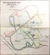
The Lowthers gave up their interest in Swillington around the time of the First World War and after the war the Bower pits were sold to Pease and Partners who had them until nationalisation. Primrose Hill was the last to close circa 1969 when the workforce either took redundancy or transferred mainly to the new Selby coalfield. After that there was a big opencast mine in the area which completely destroyed the old surface infrastructure...
Railway Memories No.15 - Pontefract, Castleford & Knottingley (Peter Cookson & Steve Chapman, Bellcode 2003) helps give a picture of the railways in the area in the 1950s and 60s. The map at the beginning of the book makes an interesting comparison with the 1879 colliery map in post #13. Bowers Row opencast and Primrose Hill colliery are both shown on a colliery branch off the Castleford to Garforth line, leaving the line at approximately the same place marked on the 1879 map as a junction with "L.C & P Railway" (Leeds, Castleford and Pontefract Junction Railway).
In the book, a Hunslet 0-6-0ST is pictured working at Primrose Hill colliery on 01/04/70. Closure date for the colliery itself is given as 06/03/70, but the caption explains that coal was still being washed there at the time the picture was taken. Bowers Row opencast (also referred to as Bowers Opencast) was already in operation by this time, and the same loco pictured at Primrose Hill in 1970 is also pictured at the nearby Bowers opencast site in 1969. The text mentions that "
much of the output from Bowers opencast was hauled to Goole docks by Goole 37s."
The signal box where the colliery branch left the Castleford to Garforth line was named "Allerton Main" and beyond this point the Cobb Atlas marks the line as being closed in 1969, which matches the text of the book. The Cobb atlas doesn't show the branch to Bowers Row or Primrose Hill (or the previous collieries shown on the 1879 map) as it understandably doesn't cover private colliery lines or other industrial railways.
This "Gazetteer of British Coal Mines" from the NMRS helps to link together the names and dates of the collieries here between the 1879 map and the one in the book showing Primrose Hill and Bowers Row Opencast:
https://www.nmrs.org.uk/assets/mines/coal/yorkshire/1854/index.html
"Allerton Main" comprised Albert, Victoria, Fleakingly Beck and Primrose Hill at various times. "Allerton Main, Primrose Hill" was renamed Primrose Hill in 1947, the same year Victoria shut, leaving it the only remaining part of Allerton Main.
From what I can make out from the lists, "Allerton Main" was the original pit opened in 1853 which became "Allerton Main, Victoria" in 1887 until closure in 1947. "Allerton Main, Albert" lasted from 1882 to 1935. "Allerton Main, Fleakingly Beck" lasted from 1888 to 1897. "Allerton Main, Primrose Hill" opened in 1893, was renamed "Primrose Hill" in 1947 (when it became the last of the Allington Main pits) and closed in 1970.
The Wikipedia entry on the
Castleford-Garforth line has a pretty good summary, and provides an opening date for Bowers Row of 1958. It's seems quite likely that once Primrose Hill colliery closed, the opencast site may have expanded into the areas where the various Allerton Main collieries once stood.
Whilst the line served a sparse population, its original intended purpose of moving coal kept it in traffic until the 1990s. Coal was forwarded out from Allerton Bywater, Allerton Main, Kippax, Lowther and Primrose Hill Collieries. Since 1958, Bowers Disposal Point was the forwarding location for coal mined from the St Aidan's opencast venture. One other coal mine, Trench Colliery, was located near to Garforth and its siding faced north, so that it only traversed a small section of the line. Trench Colliery closed down in 1930 and all freight traffic between Garforth and Ledston ended on 14 July 1969.
In the 1980s, spoil from Wheldale Colliery was taken to the tips at Allerton Bywater. This service used National Coal Board (NCB) locomotives with NCB drivers who were qualified to drive on the BR owned branch. These trains ceased in 1987 with the closure of Wheldale. About 1+1⁄2 miles (2.4 km) of track were retained from Castleford East Junction to Ledston to serve Allerton Bywater Colliery and Bowers Row Disposal Point, and later RJB Mining's Ledston Unloading Hopper Compound. These services ended on 6 June 1998.
A few useful quotes from the Railway Memories book giving or confirming closure dates:
[1969] saw complete closure between Garforth and Allerton Main Junction...
In 1989, coal trains ceased running from Bowers Row, and the Castleford - Garforth line was cut back to Allerton Bywater colliery.
All track beyond Ledston to Bowers was lifted by 1996.
Allerton Bywater colliery closed in March 1992, ending coal traffic on the line but then trains of merry-go-round hopper wagons with a brake van at each end brought spoil from the Selby mine for dumping on the tipping grounds between Ledston and the River Aire bridge. This lasted until 1996 after which the line was... officially taken out of use in 1997 during resignalling of the Castleford area.