• Our booking engine at tickets.railforums.co.uk (powered by TrainSplit) helps support the running of the forum with every ticket purchase! Find out more and ask any questions/give us feedback in this thread!

Circle and District Line Carriage Map

Joined
4 Dec 2020
Messages
186
Location
Ashford, Kent
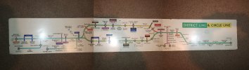
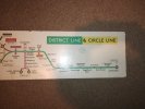
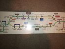
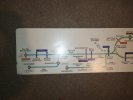
I have recently aquired a Circle and District Line Carriage Map. However i am not sure how old it is. I know for certain its pre 1990 as it does not include the Hammersmith and City Line.

I think it came out of a C Stock Train. I have seen a similar one for sale elsewhere but there is minor differences between mine and the other one i have looked at.

Any advice would be appericated.
 

Attachments

  • combine_images.jpg
    combine_images.jpg
    623.2 KB · Views: 70
  • IMG_20240209_110225767.jpg
    IMG_20240209_110225767.jpg
    4.3 MB · Views: 73
  • IMG_20240209_110230421.jpg
    IMG_20240209_110230421.jpg
    4.3 MB · Views: 60
  • IMG_20240209_110234886.jpg
    IMG_20240209_110234886.jpg
    4.8 MB · Views: 70
Sponsor Post - registered members do not see these adverts; click here to register, or click here to log in
R

RailUK Forums

etr221

Member
Joined
10 Mar 2018
Messages
1,056
No indication of the Fleet or Jubilee line, but has the Victoria line, so post 1967, and probably not that long into the 1970s. Others will be able to comment base on the diagram style; and the fact that it is District line with Circle line: this may indicate that it is ex Q/OP/R District Line stock (noting that at one stage the East London was worked by District Q stock), pre-dating the C stock; rather than a 'Met' oriented diagram, combining the Met's H&C service and Circle line. But I don't recall how the integration(s) and SSL operating balance changed (between Met Extension (to Finchley Road and beyond); Met/H&C/Circle; and District 'sections') changed in that period,
 
Last edited:

W-on-Sea

Established Member
Joined
18 Dec 2009
Messages
1,338
I think be this must be from CO/CP or R or Q stock: C stock never reached Upminster, for example. One oddity is that Bromley-by-Bow is shown as Bromley , despite its renaming (1967?) occurring before the Victoria line reached Victoria.

The dots to indicate interchange with British Rail might allow a finer dating, but my guess would be the very late 1960s: subsequent maps showing these lines (as used on the CO/CP and R stocks in their final years) has less curved depictions of the lines, both in the centre and the East.

Edit: no, the inclusion of Embankment, rather than Charing Cross, makes it later than that. And suggests the naming of "Bromley" is an error
 
Joined
4 Dec 2020
Messages
186
Location
Ashford, Kent
I think be this must be from CO/CP or R or Q stock: C stock never reached Upminster, for example. One oddity is that Bromley-by-Bow is shown as Bromley , despite its renaming (1967?) occurring before the Victoria line reached Victoria.

The dots to indicate interchange with British Rail might allow a finer dating, but my guess would be the very late 1960s: subsequent maps showing these lines (as used on the CO/CP and R stocks in their final years) has less curved depictions of the lines, both in the centre and the East.

Edit: no, the inclusion of Embankment, rather than Charing Cross, makes it later than that. And suggests the naming of "Bromley" is an error
No indication of the Fleet or Jubilee line, but has the Victoria line, so post 1967, and probably not that long into the 1970s. Others will be able to comment base on the diagram style; and the fact that it is District line with Circle line: this may indicate that it is ex Q/OP/R District Line stock (noting that at one stage the East London was worked by District Q stock), pre-dating the C stock; rather than a 'Met' oriented diagram, combining the Met's H&C service and Circle line. But I don't recall how the integration(s) and SSL operating balance changed (between Met Extension (to Finchley Road and beyond); Met/H&C/Circle; and District 'sections') changed in that period,

Thank you both your help. Much appericated. I managed to find a picture of the map in a CO/CP stock (ex Q38 trailer.). Not the best photo but that helps massively.


Basil Jet

On Moderation
Joined
23 Apr 2022
Messages
989
Location
London
I'm interested in the green ghost roundel beneath the "District Line & Circle Line" label. Did other colour ghost roundels exist, and where and when were they used?
 

Dstock7080

Established Member
Joined
17 Feb 2010
Messages
2,770
Location
West London
I'm interested in the green ghost roundel beneath the "District Line & Circle Line" label. Did other colour ghost roundels exist, and where and when were they used?
Metropolitan line diagrams of the mid-70s had similar roundels
 

Man of Kent

Member
Joined
5 Jul 2018
Messages
601
Having checked pocket maps from the early 1970s, Moorgate was not shown as a BR interchange, so I suspect this diagram is no earlier than 1976, when the GN&C was taken over by BR.
 

edwin_m

Veteran Member
Joined
21 Apr 2013
Messages
24,941
Location
Nottingham
Having checked pocket maps from the early 1970s, Moorgate was not shown as a BR interchange, so I suspect this diagram is no earlier than 1976, when the GN&C was taken over by BR.
Before that Moorgate would have been a BR interchange with the Widened Lines services.
 

Top