• Our booking engine at tickets.railforums.co.uk (powered by TrainSplit) helps support the running of the forum with every ticket purchase! Find out more and ask any questions/give us feedback in this thread!

Measuring using chains

Status
Not open for further replies.

zwk500

Veteran Member
Joined
20 Jan 2020
Messages
13,540
Location
Bristol
Moving the stops back would render the miles based measurements slightly out as well, surely?

Are there any rules that, in these circumstances, would have prevented them saying the buffer stops were at "minus distance"?
Several examples of minus distance on the network, so no problem there (although not very neat, I'm sure a proud 'Western' man wouldn't want to smudge Brunel's legacy).
I believe that, certainly at some terminals, the datum (zero point) was the property line, and not the end (or should I say start) of track - Paddington may well be such.
Possibly. RCH rules were that the distance should be taken from the most extreme buffer stop but of course those rules were standardised after some railways had already published their distances.
And the reason why the distance between the Roman chariot wheels is what it is.

It is because that was the average width of a Horses Ass
Two horses, according to numerous online sources.
There is no specific relation between the width of a horse and 4'8.5". It's a rough approximation only. The very many early gauges around this width show we could just as easily ended up with Irish gauge or something.
 
Sponsor Post - registered members do not see these adverts; click here to register, or click here to log in
R

RailUK Forums

edwin_m

Veteran Member
Joined
21 Apr 2013
Messages
25,013
Location
Nottingham
It's usually a really bad idea to move the datum (zero point), because that changes all the chainages all the way along the route, and there is a risk of confusion if all records aren't updated.
 

zwk500

Veteran Member
Joined
20 Jan 2020
Messages
13,540
Location
Bristol
It's usually a really bad idea to move the datum (zero point), because that changes all the chainages all the way along the route, and there is a risk of confusion if all records aren't updated.
Yes and this is a big reason the mileages are largely fixed, even when they no longer make sense in terms of the maintenance or operation of the line. Although equally if there is a change in the distance and the datum isn't changed, it can also cause confusion! Short/long miles around diversions are the classic example.
 

edwin_m

Veteran Member
Joined
21 Apr 2013
Messages
25,013
Location
Nottingham
Yes and this is a big reason the mileages are largely fixed, even when they no longer make sense in terms of the maintenance or operation of the line. Although equally if there is a change in the distance and the datum isn't changed, it can also cause confusion! Short/long miles around diversions are the classic example.
In that case they should define a new Engineers Line Reference (ELR, usually keeping the same three letters but changing the final digit) and publish the tie-ins where the old and new chainages meet. But I agree it doesn't always happen.
 

geoffk

Established Member
Joined
4 Aug 2010
Messages
3,274
This is the opposite of Manchester Metrolink where speeds are in mph but, as mentioned by LNW-GW Joint, distances are metric.
Converting everything to metric, while clearly sensible, would have the Brexiters foaming at the mouth and reaching for their Daily Mail.
 

zwk500

Veteran Member
Joined
20 Jan 2020
Messages
13,540
Location
Bristol
In that case they should define a new Engineers Line Reference (ELR, usually keeping the same three letters but changing the final digit) and publish the tie-ins where the old and new chainages meet. But I agree it doesn't always happen.
That's my position as well, but in my experience the ELR doesn't change for erratic miles. I did ask a few people to mark those miles in NESA but it never went anywhere. I don't know if there's a standard where a mile can be up to a certain distance over/under, but I know that the ELR at Lewes and Wolverton doesn't change for the erratic miles (both a couple of hundred yards), and I'm fairly sure the Salisbury/Fisherton one doesn't either.

Converting everything to metric, while clearly sensible, would have the Brexiters foaming at the mouth and reaching for their Daily Mail.
Oh dear. What a shame. Never mind.
 

LNW-GW Joint

Veteran Member
Joined
22 Feb 2011
Messages
19,770
Location
Mold, Clwyd
Converting everything to metric, while clearly sensible, would have the Brexiters foaming at the mouth and reaching for their Daily Mail.
But these people already buy petrol in litres and check their airline luggage in kgs, and their brethalyser readings will be in mg/100ml. ;)
 

snowball

Established Member
Joined
4 Mar 2013
Messages
7,784
Location
Leeds
Knot - 1 nautical mile per hour. Nautical miles are 1 minute (1/60 degree) of latitutde, equal to 1.15 statute miles.
The symbol "nm" properly means nanometres, but is sometimes improperly used for nautical miles, each of which is 1852000000000 nanometres.
 

Annetts key

Established Member
Joined
13 Feb 2021
Messages
2,660
Location
West is best
Another point to consider (and I have to on a daily basis) - mileposts, quarters, half and three quarters on the track can be notoriously inaccurate
It’s been known by long serving track workers that many of these are somewhat out of position. In places where the chainage is still painted on the rails, it’s not uncommon for the chain mark to be different to the nearby post…

Also re the use of chains - a lot of the old NR / BR records are in miles & chains.
In a lot of areas where there has been no recent infrastructure investment, most records and documentation will be in miles & chains, or miles & yards. Sometimes in feet as well.

Existing signalling and telecommunications cable lengths are listed in yards. Although new cables are now measured and listed in metres.

There are also discrepancies between different sets of records. Including the mileage & chainage where the ELR (Engineers Line Reference) changes on what is now ‘plain line’!

"Is it an urban myth or did it really happen" No.97: in the 1970s BR wanted to embrace modern Continental-style metrication and eliminate old-fashioned miles, furlongs and chains. The Western Region main line was chosen for a pilot project and kilometre posts were installed from the buffer-stops at Paddington all the way to those at Penzance. It took a lot of surveying, a long time and considerable expense. However, just as the final post was put in place on the approach to Penzance, it was decided to extend the Lawn at Paddington by a few metres and the buffer-stops were duly moved a few metres west. This at a stroke rendered all the new posts inaccurate. Shortly afterward the whole scheme was quietly dropped. At least, that's what a fellow-railwayman told me in a pub once. Can anyone corroborate this sad story?
Sounds like a nice yarn that the person in the pub spun for you.

I’ve seen absolutely no sign of any kilometre posts lineside or any references in any BR 1970s or later documentation. Parts of the Western Region have never even moved the mile posts, quarter, half and three quarter posts from the downside to the upside (normal practice is to have them on the up side, but on some lines, due to historical reasons they are on the downside) or replaced the non-Western type with Western types or the current style.

Until the TVSC signalling scheme, I had never seen km used on the railway in my area. GWML ATP has however used metric metres for the distances and positions of the beacons and of the length of the infill loops. And the dimensions of various signalling equipment, allowable tolerances, specifications, checking gauges have been metric for many, many years.

Now all the TVSC signalling plans for my area all use metres for the distance and location measurements. Mile posts, quarter, half and three quarter posts are however still shown. Each has their location shown in metres below them. Like this:
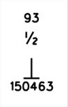
E1BAC4C4-19F5-458D-8BEE-FCAD8A23121E.jpeg

Nearly everything else is in metric on these plans.

So, I often find myself converting between metres and imperial.
 
Last edited:

Ken H

On Moderation
Joined
11 Nov 2018
Messages
6,355
Location
N Yorks
But these people already buy petrol in litres and check their airline luggage in kgs, and their brethalyser readings will be in mg/100ml. ;)
Does anybody buy petrol in litres. I either fill up, or put in £70 or whatever. No idea how many litres I buy. The price/litre is just a way of comparing prices
 

BingMan

Member
Joined
8 Feb 2019
Messages
150
By remembering either 1.6 or 5/8. They're not 'incompatible', just in different scales.

If you're looking for jobs with NR you better get used to jumping between Yards, meters, Miles, and Kilometres. The number you'll need for engineering precision is 1.609344. You may also want to try and get your head around SLU, or Standard Length Unit (21ft).
To a few barley corns a kilometre is 5 furlongs.
 

LNW-GW Joint

Veteran Member
Joined
22 Feb 2011
Messages
19,770
Location
Mold, Clwyd
Existing signalling and telecommunications cable lengths are listed in yards. Although new cables are now measured and listed in metres.
Nearly everything else is in metric on these plans.
So, I often find myself converting between metres and imperial.
GW electrification structures will have metric identification plates (XX km nn).
 
Last edited:

zwk500

Veteran Member
Joined
20 Jan 2020
Messages
13,540
Location
Bristol
What are they used for?
I've heard of TEUs (Twenty-foot Equivaleent Units) for containers.
SLUs are used to measure train and infrastructure length. It's based off the old standard length of a 4-wheel wagon, so 1 SLU = 1 Wagon. Hence a siding that was 20 SLU long could hold 20 wagons. Of course, now most wagons are much longer than 21ft, so it's fairly useless but some documents still have length only in SLU.
 

Llanigraham

On Moderation
Joined
23 Mar 2013
Messages
6,105
Location
Powys
The Cambrian has had 2 recalculations of length that I know of.
One quite extensive one when the new bridge and alignement was done at Pont Briwet, and a second lesser one when they increased the over water height of Black Bridge, just out of Mach Station. Not sure what happened when they lifted the line through Dyfi Junction above flood level.
 

DelW

Established Member
Joined
15 Jan 2015
Messages
3,917
So will that be changed in the future when the metric-educated generation who are used to work in km and km/h (i.e. those born after the 1970s) become the majority in the workplace?
Well most of the current workforce was brought up post-metrication, which actually took place in the late 1960s. I doubt that road signs and road speed limits will ever be changed from miles and mph to km and km/h, since the cost would be huge, the benefits few, and confusion would be caused during the changeover. So almost all train drivers will still be familiar with imperial measures of distance and speed in that context.
It's cumbersome to work when the distance is in km and the speed is in mph, or vice versa. For example, when you are driving at 60 km/h, you pass a km post one minute; at 120 km/h, half a minute. How long do you need to drive 11 km at 60 mph? UK motorways are exactly the same as London Underground in this respect as they are also measured in km, but the speed limit are in mph.
Who on earth still measures speeds by timing between marker posts? Train timers stopped doing it decades ago when GPS became available, and I doubt many car drivers are even aware that there are distance posts on motorways, let alone what they represent.
 

snowball

Established Member
Joined
4 Mar 2013
Messages
7,784
Location
Leeds
Well most of the current workforce was brought up post-metrication, which actually took place in the late 1960s.
I think more metrication took place in the UK in the 70s than the 60s. The transition to decimal coinage was completed in 1971 and the general public were still using mostly imperial weights and measures at that time. The Metrication Board was created by the then Labour government in 1969 and abolished by Thatcher in 1981 with the planned transition still incomplete. Road design switched to metric around 1973 and was probably typical of technical professions. Scientists had already been using metric for a long time.

I moved from primary to secondary school in 1960 and did lots of work in both systems at both schools.
 

Railsigns

Established Member
Joined
15 Feb 2010
Messages
2,512
IIRC Network Rail Scotland Route (alone?) uses miles and yards, not chains. Which made things interesting on the odd occasion measurements across the Route Boundary were required!
There was a period in which the Scottish Sectional Appendix uniquely expressed mileages in miles and yards, but it reverted to using miles and chains many years ago.
 

Railsigns

Established Member
Joined
15 Feb 2010
Messages
2,512
That must have been after I retired in 2016, because we were certainly using miles and yards for things like Speed Restrictions then!
The Scottish Weekly Operating Notices use miles and yards in Section A (temporary speed restrictions) and Section B (engineering arrangements), whereas all the other NR WONs use miles and chains.
 

AndrewE

Established Member
Joined
9 Nov 2015
Messages
5,111
Knot - 1 nautical mile per hour. Nautical miles are 1 minute (1/60 degree) of latitutde, equal to 1.15 statute miles.
Not quite, as the circles of latitude shrink as you progress from the equator towards either pole! I would have said "(1/60 degree) of latitude at the equator" but Wikipedia (https://en.wikipedia.org/wiki/Nautical_mile) is more precise:
By the late 16th century, Englishmen knew that the ratio of distances at sea to degrees was constant along any great circle such as the equator or any meridian, assuming that Earth was a sphere. Robert Hues wrote in 1594 that the distance along a great circle was 60 miles per degree, that is, one nautical mile per arcminute.
so a nautical mile is 1/60 of a degree of longitude or on the equator, or any other Great Circle.
 

Bevan Price

Established Member
Joined
22 Apr 2010
Messages
7,370
For scheme plans and that sort of thing, the (unconfirmed) impression I got was that the survey team would pick a known point such as a milepost or something mentioned in NESA, then convert that mileage into meters and use that point as a datum to calculate all other locations on the plan in metric. It got really fun if there was a short mile or something like that in the area as they're not mentioned in NESA and so they weren't mentioned as a mileage change on the plan, breaking the convertibility of the meterage back to mileage.
There was also one set of drawings I remembered seeing where the survey had started at Waterloo and put the Zero Metre datum on the buffers, understandably. However, because the Zero Milepost for the SWML is in fact at Waterloo East, this meant the meterage was about 3/8ths of a mile out with the mileage for all the drawings in that set.
Mileposts on the Waterloo - Exeter line are a total mess. The difference between actual & milepost distances gradually increases all the way to Exeter, but not in any consistent pattern. Presumably different - and erroneous - surveyors chains were used during the original construction ??
 

DelW

Established Member
Joined
15 Jan 2015
Messages
3,917
I think more metrication took place in the UK in the 70s than the 60s. The transition to decimal coinage was completed in 1971 and the general public were still using mostly imperial weights and measures at that time. The Metrication Board was created by the then Labour government in 1969 and abolished by Thatcher in 1981 with the planned transition still incomplete. Road design switched to metric around 1973 and was probably typical of technical professions. Scientists had already been using metric for a long time.

I moved from primary to secondary school in 1960 and did lots of work in both systems at both schools.
The Metrication Board was evidently rather later than I thought, I'd thought it was around 1966-7. But a lot of metric design codes for civil engineering were introduced in 1969, e.g. the metric editions of BS449 (structural steelwork) and CP114 (reinforced concrete) .

Road design, at least in some areas, must have switched a little earlier than 1973. I started setting out bridges on the A45* Stowmarket Bypass in summer 1973, and all our drawings and alignments were in metric, so Eastern Road Construction Unit must have already been working in metric throughout the earlier design phase.

My engineering career lasted from 1973 until 2019 and I never worked in, nor was taught (engineering) in, imperial units; so although other industries may have been slower to convert, I don't think there will be many left working in industry who learned their trade pre-metrication.

(* now renumbered A14)
 
Status
Not open for further replies.

Top