I would have thought that technology exists to provide almost instant and continuous monitoring and warning of impending failure.I see that you are asking another question rather than providing a definitive answer. It is widely known that 'red zone' working, such as staff patrolling whilst trains are running on both lines has effectively ceased and on a line relatively busy with both passenger and freight trains it must be almost impossible to find margins in daylight.
I thought that there was far more emphasis on things like track recording coach runs and fixed sensors these days. So the monitoring continues but in a far safer fashion.
It would be great to have an answer from Network Rail.
-
Our booking engine at tickets.railforums.co.uk (powered by TrainSplit) helps support the running of the forum with every ticket purchase! Find out more and ask any questions/give us feedback in this thread!
You are using an out of date browser. It may not display this or other websites correctly.
You should upgrade or use an alternative browser.
You should upgrade or use an alternative browser.
New Mills Central landslip - 6 week closure
- Thread starter londonmidland
- Start date
Sponsor Post - registered members do not see these adverts; click here to register, or click here to log in
R
RailUK Forums
175001
Established Member
The 20mph TSR has been on it for nearly 2 years. They've had plenty of time to think about sorting it out
Is there any suggestion that Network Rail didn't know about the issue?I would have thought that technology exists to provide almost instant and continuous monitoring and warning of impending failure.
railfan99
Established Member
At least they can run to Sheffield via Stockport so the disruption is fairly minimal (does anyone use Strines?). Marple pax may enjoy having empty trains to board!
Plenty of Australians use 'Strine':
Strine: Text Classics, book by Afferbeck Lauder
How’s your ebb tide?Do you sign on the dotted lion?Is your tea nature Orpheus Rocker?Who is Charlie Charm Puck in ‘Waltzing Matilda’?There was never any book about Australian speech like Strine or about posh British speech like Fraffly Well Spoken.Here, collected in one volume, are Afferbeck...
 www.textpublishing.com.au
Strine
It was Professor Afferbeck Lauder who made the groundbreaking discovery that Australians speak Strine - not English, as had long been thought. He revealed his findings in a little book called Let Stalk Strine, an instant classic and - as John Clarke writes in his Ford - a publishing phenomenon...
books.google.com.au
I may have to visit this station on my next visit to the UK. It could be a non-religious pilgrimage destination for Ockers (of which I am not one).
Seriously though, I have been through New Mills Central that IIRC until recently had a wonderful signalbox nearby, recently decommissioned. I hope the situation is rectified. It reminds one of the fairly recent problems West Somerset Railway allegedly 'enjoyed' with a tenant farmer.
edwin_m
Veteran Member
It certainly does, and at a site with known issues (hence the 5mph TSR) I would expect it to have been installed.I would have thought that technology exists to provide almost instant and continuous monitoring and warning of impending failure.
This may well be why trains were stopped and a serious accident possibly avoided.
Indeed.It certainly does, and at a site with known issues (hence the 5mph TSR) I would expect it to have been installed.
This may well be why trains were stopped and a serious accident possibly avoided.
From p84 of Network Rail's Strategic Business Plan for Control Period 7: https://www.networkrail.co.uk/wp-co...and-and-Wales-CP7-Strategic-Business-Plan.pdf
The [Mair and Slingo Task Force] reviews [carried out following the tragic Carmont derailment] recognised it’s not practical to rebuild nearly 200,000 separate slopes alongside the railway, and they recognise the work that has been done to upgrade the Victorian infrastructure where possible and manage risk across the network.
Investment in resilience work has increased in the past decade, and new systems, technology, standards,
and practices have been introduced or updated. The reports also note that this work has accelerated
further since the summer of 2020. This has included trials of new technology being rolled out more
widely across the network ...
Killingworth
Established Member
I see Network Rail are now writing about 2 locations near New Mills; https://www.networkrailmediacentre....-carries-out-emergency-work-to-the-embankment
Saphos White Rose was due to go that way on 17th and has had to be diverted via Huddersfield.
Saphos White Rose was due to go that way on 17th and has had to be diverted via Huddersfield.
ruaival
Member
Walk-around look-see at lunchtime today suggests that inspections are underway closer to Hague Bar than New Mills and with (ready in waiting) grab bags of ballast at a separate location nearer New Mills Central where the 5mph speed restriction has been starting for many months now.
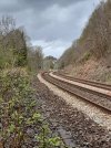
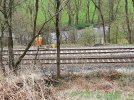
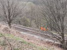
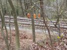
Attached are a context map - I walked the 4 sided route between the marked pins using the foot crossing - and various photos showing the rail-top Stop sign, access walkway rising about 50 feet, closest road bridge view and lots of affected track that to my untrained eye looks decidedly not level, not fully ballast supported and on the edge of whatever counts for track bed at this point.
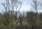
The ground below the affected area is a Reed Bed - attracting birds? - as part of Mousley Bottom, a very boggy natural habitat on the bank of the River Goyt.
Attached are a context map - I walked the 4 sided route between the marked pins using the foot crossing - and various photos showing the rail-top Stop sign, access walkway rising about 50 feet, closest road bridge view and lots of affected track that to my untrained eye looks decidedly not level, not fully ballast supported and on the edge of whatever counts for track bed at this point.
The ground below the affected area is a Reed Bed - attracting birds? - as part of Mousley Bottom, a very boggy natural habitat on the bank of the River Goyt.
Attachments
-
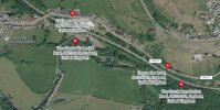 Context Map - Hague Bar.jpg270.3 KB · Views: 219
 -
 Looking West along track to affected area - Hague bar industrial unit beyond.jpg417.9 KB · Views: 214
 -
 Looking North - the constructed walkway up to trackside.jpg179.6 KB · Views: 197
 -
 Looking East as 1200 arrival approaches New Mills - just passing signal West of affected area.jpg99.5 KB · Views: 194
 -
 Looking South across from last few houses of Hague Bar - affected line not looking level.jpg534.5 KB · Views: 198
 -
 Looking South at the top of the access walkway - dodgy looking affected track here also.jpg564.6 KB · Views: 196
 -
 Looking South from a little further East - affected line ballast not looking good.jpg555.4 KB · Views: 183
 -
 Looking South just level with hague Bar speed limit - current focus of attention when I passed.jpg550.4 KB · Views: 212
Killingworth
Established Member
Not yet a landslide, barely a land slip, but certainly significant subsidence that needs attention before it does slip or slide away. Good and helpful pictures confirming it's not as bad as may be suggested in some descriptions.Walk-around look-see at lunchtime today suggests that inspections are underway closer to Hague Bar than New Mills and with (ready in waiting) grab bags of ballast at a separate location nearer New Mills Central where the 5mph speed restriction has been starting for many months now.
Attached are a context map - I walked the 4 sided route between the marked pins using the foot crossing - and various photos showing the rail-top Stop sign, access walkway rising about 50 feet, closest road bridge view and lots of affected track that to my untrained eye looks decidedly not level, not fully ballast supported and on the edge of whatever counts for track bed at this point.
The ground below the affected area is a Reed Bed - attracting birds? - as part of Mousley Bottom, a very boggy natural habitat on the bank of the River Goyt.
Can a second location be identified, or is that all part of the same section?
ruaival
Member
All my photos looking South are from less than a 200m walk along the road.Not yet a landslide, barely a land slip, but certainly significant subsidence that needs attention before it does slip or slide away. Good and helpful pictures confirming it's not as bad as may be suggested in some descriptions.
Can a second location be identified, or is that all part of the same section?
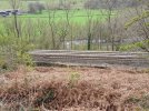
Ballast in 'rubble bags' - about 4 or 5 - are South side of track *much* nearer the stabling siding at New Mills Central itself and have been there from before this issue was declared.
Hopefully local names- like Waterside, Riverside, Brook Bottom, Seven Springs and Springbank- will have informed engineers and tracklayers of likely 'issues'.Not yet a landslide, barely a land slip, but certainly significant subsidence that needs attention before it does slip or slide away. Good and helpful pictures confirming it's not as bad as may be suggested in some descriptions.
Can a second location be identified, or is that all part of the same section?
Leyland155
Member
- Joined
- 25 Jul 2016
- Messages
- 111
New Mills Central box is definitely still in use, it's just south of the platforms. It fringes with Manchester East SCC to the north, and New Mills South Junction SB which is, unsurprisingly, to the southSeriously though, I have been through New Mills Central that IIRC until recently had a wonderful signalbox nearby, recently decommissioned.
175001
Established Member
The initial TSR of 20mph had been there for about 18 months.
The 5mph was implemented in January, it was then raised back to 20 before it was put back to 5 a few weeks ago.
They've known about it for a long time
New Mills Central box still in use. It where the Pilot goes for a brew between trains.
The 5mph was implemented in January, it was then raised back to 20 before it was put back to 5 a few weeks ago.
They've known about it for a long time
New Mills Central box still in use. It where the Pilot goes for a brew between trains.
AlastairFraser
Established Member
- Joined
- 12 Aug 2018
- Messages
- 2,165
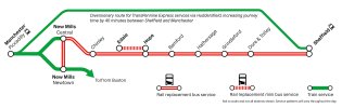
I don't know if you're local, but a lot of the roads are horrifically narrow, and plenty of turns too tight for buses too (as well as low bridges to consider near Chinley/Buxworth).In the journey planner, it seems that the Rail replacement services have 35 minutes Chinley- New Mills and 30 mins New Mills- Chinley.
However, it seems the journey is only approx 15 minutes, so why do they have 35 mins to do it?!
View attachment 155373
For example, look at this turn at Bridgemont (between Furness Vale and Whaley Bridge), on one of the routes between Chinley and New Mills Central:
A6/B6062 junction Bridgemont
Or this turn coming onto the A6 from the centre of New Mills:
A6 New Mills Newtown
Low bridge on the north side of Chinley (on the A624 route Google has given you): A624 New Smithy/Chinley
175001
Established Member
I did the RRB last week and it went via Hayfield 
ruaival
Member
Probably ran parallel to the Sett Valley line out of New Mills but did not make a passenger call at Hayfield (1868-1970) itself - it is the easier road route as highlighted by @AlastairFraser pictures above.I did the RRB last week and it went via Hayfield
One of the challenges in this area is the terrain and recent upgrade works rail replacement buses gave only a clunky alternative to driving across to Edale for a walking day: New Mills to Hope then Hope to Edale; they "can't move mountains".
Attachments
Though locals of course will know of mountains moving themselves- like 'the shivering mountain' of Mam Tor not that far away, or maybe a bit closer now ... ? SorryProbably ran parallel to the Sett Valley line out of New Mills but did not make a passenger call at Hayfield (1868-1970) itself - it is the easier road route as highlighted by @AlastairFraser pictures above.
One of the challenges in this area is the terrain and recent upgrade works rail replacement buses gave only a clunky alternative to driving across to Edale for a walking day: New Mills to Hope then Hope to Edale; they "can't move mountains".
Killingworth
Established Member
Though locals of course will know of mountains moving themselves- like 'the shivering mountain' of Mam Tor not that far away, or maybe a bit closer now ... ? Sorry
Interestingly the Hope Valley Capacity Scheme was to deliver an extra fast path across the Pennines (which it does but no capacity into Manchester to take advantage) and also suggested quicker journeys, which it hardly can.
Part of the reason is the high cost of maintaining high speed tracks through terrain that has been subject to subsidence for thousands of years long before the railways started interfering. Mam Tor is just the largest of many slippages that will continue for many thousands more years. When this one is resolved there are bound to be others.
Has the Hope Valley Capacity Scheme been a waste of money? The current and ongoing lack of capacity into Manchester Piccadilly, (increasing?) likelihood of changing and challenging ground slippages, and likely lack of availability or allocation of funds, etc, etc, suggest a 'need' for a broader review of the future of british railways (to paraphrase 'Beeching', 'Serpell', etc?)Interestingly the Hope Valley Capacity Scheme was to deliver an extra fast path across the Pennines (which it does but no capacity into Manchester to take advantage) and also suggested quicker journeys, which it hardly can.
Part of the reason is the high cost of maintaining high speed tracks through terrain that has been subject to subsidence for thousands of years long before the railways started interfering. Mam Tor is just the largest of many slippages that will continue for many thousands more years. When this one is resolved there are bound to be others.
The Planner
Veteran Member
- Joined
- 15 Apr 2008
- Messages
- 15,994
Chicken and egg. Do you wait until Manchester is solved then do Hope Valley (likely meaning it gets more expensive and never gets done), or do you build it and take some of the benefits and its there for when Manchester is resolved? Opens the debate of incremental enhancements that lead to a bigger picture later (later being quite expansive in time limits), or do it all in one go, or not at all.Has the Hope Valley Capacity Scheme been a waste of money? The current and ongoing lack of capacity into Manchester Piccadilly, (increasing?) likelihood of changing and challenging ground slippages, and likely lack of availability or allocation of funds, etc, etc, suggest a 'need' for a broader review of the future of british railways (to paraphrase 'Beeching', 'Serpell', etc?)
You put it better than me (my sarcasm doesn't 'come over' very well). The great is the enemy of the good. Something is better than nothing. At times of shortages of funding (and political 'support' (as per HS2?) it is good to get going on what can be done when it can be.Chicken and egg. Do you wait until Manchester is solved then do Hope Valley (likely meaning it gets more expensive and never gets done), or do you build it and take some of the benefits and its there for when Manchester is resolved? Opens the debate of incremental enhancements that lead to a bigger picture later (later being quite expansive in time limits), or do it all in one go, or not at all.
Killingworth
Established Member
You put it better than me (my sarcasm doesn't 'come over' very well). The great is the enemy of the good. Something is better than nothing. At times of shortages of funding (and political 'support' (as per HS2?) it is good to get going on what can be done when it can be.
We've rather strayed from the thread topic however the route via Marple is normally an important diversionary option for fast services between Sheffield and Manchester. Today it's the other way round, stoppers are diverting via Hazel Grove.
On 17th April LSL's White Rose is having to divert via Stalybridge and Huddersfield. This at a time when the Hope Valley route is needed for diversions away from TRU, like the Drax biomass trains.
The Hope Valley scheme grew out of planned redoubling at Dore which seems to have begun by 1999 with Railtrack planning to deliver in CP5 2003-4. It grew and got swept up into the Manchester Hub, that became the Northern Hub that delivered the Ordsall Chord, but not Platforms 15/16 at Piccadilly.
The difficulty at New Mills, and all along most of our Victorian railways, is that old drainage combined with over a century of wet and dry weather periods makes movement increasingly likely.
I understand work on the Hope Valley scheme included replacing old clay pipe drainage that in some places was totally blocked with decades of silt.
edwin_m
Veteran Member
At the time, HS2 was expected to release some capacity through Stockport and into Piccadilly in the 2030s.Has the Hope Valley Capacity Scheme been a waste of money? The current and ongoing lack of capacity into Manchester Piccadilly, (increasing?) likelihood of changing and challenging ground slippages, and likely lack of availability or allocation of funds, etc, etc, suggest a 'need' for a broader review of the future of british railways (to paraphrase 'Beeching', 'Serpell', etc?)
Another reminder to short-term , transient 'here today, gone tomorrow' politicians of the unconsidered effects of less-the-fully considered decisiveness? ... I couldn't possibly comment.At the time, HS2 was expected to release some capacity through Stockport and into Piccadilly in the 2030s.
AlastairFraser
Established Member
- Joined
- 12 Aug 2018
- Messages
- 2,165
Exactly, but even then, going via Hayfield you have to hire quite a small bus as an RRB to get under the arch bridge at New Smithy on the A624 that I posted.Probably ran parallel to the Sett Valley line out of New Mills but did not make a passenger call at Hayfield (1868-1970) itself - it is the easier road route as highlighted by @AlastairFraser pictures above.
ruaival
Member
Not disagreeing, your other two photos show the challenge of using the A6 that might seem obvious to some.Exactly, but even then, going via Hayfield you have to hire quite a small bus as an RRB to get under the arch bridge at New Smithy on the A624 that I posted.
AlastairFraser
Established Member
- Joined
- 12 Aug 2018
- Messages
- 2,165
True, no easy options in the High Peak!Not disagreeing, your other two photos show the challenge of using the A6 that might seem obvious to some.
furnessvale
Established Member
- Joined
- 14 Jul 2015
- Messages
- 4,583
At 12' 9" high New Smithy bridge should be capable of passing a standard single deck bus which is considered large enough for the much busier 199 Skyline service.Exactly, but even then, going via Hayfield you have to hire quite a small bus as an RRB to get under the arch bridge at New Smithy on the A624 that I posted.
AlastairFraser
Established Member
- Joined
- 12 Aug 2018
- Messages
- 2,165
Sure, the issue with Northern RRBs is that often they just get what they're given. I used to commute on the Buxton line and there was a proper motley collection that turned out whenever the line was shut.At 12' 9" high New Smithy bridge should be capable of passing a standard single deck bus which is considered large enough for the much busier 199 Skyline service.
We nearly got stuck on a lane near Dove Holes station with a bus that was significantly oversized for the job.
Kipperthecat
Member
In the Torrs car park there was six lengths of plastic drainage in the Murphy’s temporary compound, which could offer a clue to the issue.
On my walk round (I did same walk as ruaival above) I also noticed that the path next to the river Goyt has been fenced off close to the area of the subsidence, which appears to be due to erosion from the river. Between the river and railway embankment is the reed bed and saturated ground (there are wooden walk boards at this location)
There is drainage slightly beyond the area of concern which appears to be functioning, but the lie of the land would suggest the water flows to the bottom of the embankment near the reed bed.
I don’t think a few bags of ballast will solve this. It looks more like an Eden Brows scenario to me !