• Our booking engine at tickets.railforums.co.uk (powered by TrainSplit) helps support the running of the forum with every ticket purchase! Find out more and ask any questions/give us feedback in this thread!

Brighton Mainline 4G/5G upgrades

Gigabit

Member
Joined
7 Dec 2022
Messages
187
Location
United Kingdom
The plan was always for all 4 MNOs, I believe. There's sufficient infrastructure (4 sets of radio panels) in the planning docs for this.

View attachment 157028

I believe so but contractual agreements could be imposed to force them to join every site rather than a selection.

Thanks, you have been a font of knowledge on this.

Sorry for the slightly dumb questions but if one MNO has good coverage on a part of the route already, are they going to let other MNOs use the site under this scheme or will they build a new one? I understood one of the tunnels had a situation with good coverage on O2/VF but not EE and Three.

Additionally, I understood they planned to install infrastructure in the tunnels too and also some specialist solutions in the cuttings, do these also require planning permission?

I am also always curious what "good" coverage on a train is, is there a figure the MNOs will target to consider sufficient coverage?

Thanks!
 
Sponsor Post - registered members do not see these adverts; click here to register, or click here to log in
R

RailUK Forums

MrJeeves

Established Member
Joined
28 Aug 2015
Messages
1,995
Location
Burgess Hill
Thanks, you have been a font of knowledge on this.
Most of my knowledge comes from what others have taught me over years. I should be thanking them too! :p
Sorry for the slightly dumb questions but if one MNO has good coverage on a part of the route already, are they going to let other MNOs use the site under this scheme or will they build a new one? I understood one of the tunnels had a situation with good coverage on O2/VF but not EE and Three.
No plans for site sharing I'm aware of, other than the general agreements operators have.

The BML isn't quite bad enough to need a Shared Rural Network style solution being rolled out elsewhere. Much rather let private equity backed firms do it and then try to make it profitable.
Additionally, I understood they planned to install infrastructure in the tunnels too and also some specialist solutions in the cuttings, do these also require planning permission?
It depends... Stuff like the radio rooms may do, if they are going to require building modifications or new buildings like that one at Haywards Heath did.

The actual equipment, though, shouldn't need planning permission to add into tunnels and the like. That's all hidden away
I am also always curious what "good" coverage on a train is, is there a figure the MNOs will target to consider sufficient coverage?
Each network has their own coverage standards they try to meet.

I remember that Vodafone used to have their own minimum throughput for a "good 4G connection" which was something like 128 Kbps! That was a number of years ago now, and I'd like to think that's changed.

Some will use RSRP predictions (essentially the signal strength) while others will also throw in interference predictions (RSRQ/SINR) and others will throw in capacity/demand information too. Some networks pretend the entire country is completely flat, too, but I think that one might no longer apply as of a few weeks ago but I've forgotten now.
 
Joined
31 Dec 2019
Messages
643
Location
uk
Whilst this is still being constructed, what's currently the best MNO for an average punter on the BML?
 

MrJeeves

Established Member
Joined
28 Aug 2015
Messages
1,995
Location
Burgess Hill
Whilst this is still being constructed, what's currently the best MNO for an average punter on the BML?
No clear answer, really. I find O2, then Vodafone most reliable from end to end.

But EE shine more towards the southern end, post Haywards Heath as well as after East Croydon. They're terrible between Haywards Heath and Three Bridges though.

Three is just a laughing stock throughout, and I wouldn't recommend them unless you happen to live in an area well-covered by their 5G (which is actually the fastest in the country).
 

Gigabit

Member
Joined
7 Dec 2022
Messages
187
Location
United Kingdom
Most of my knowledge comes from what others have taught me over years. I should be thanking them too! :p

No plans for site sharing I'm aware of, other than the general agreements operators have.

The BML isn't quite bad enough to need a Shared Rural Network style solution being rolled out elsewhere. Much rather let private equity backed firms do it and then try to make it profitable.

It depends... Stuff like the radio rooms may do, if they are going to require building modifications or new buildings like that one at Haywards Heath did.

The actual equipment, though, shouldn't need planning permission to add into tunnels and the like. That's all hidden away

Each network has their own coverage standards they try to meet.

I remember that Vodafone used to have their own minimum throughput for a "good 4G connection" which was something like 128 Kbps! That was a number of years ago now, and I'd like to think that's changed.

Some will use RSRP predictions (essentially the signal strength) while others will also throw in interference predictions (RSRQ/SINR) and others will throw in capacity/demand information too. Some networks pretend the entire country is completely flat, too, but I think that one might no longer apply as of a few weeks ago but I've forgotten now.

Thanks again.

But I am still a bit confused how they will choose where to put the sites if there is no sharing of existing sites going on, is it just places where there is currently no coverage from any of the MNOs? I am struggling to see how that would provide coverage for every operator as there would presumably be places left where some cover but others don't?

There are some lines I use often which pass through areas of no coverage particularly on MOD land, which I assume have never been tackled for that reason. My hope would be that some day there can be a solution to those but I suspect it would require putting equipment on Network Rail's land.
 

MrJeeves

Established Member
Joined
28 Aug 2015
Messages
1,995
Location
Burgess Hill
Thanks again.

But I am still a bit confused how they will choose where to put the sites if there is no sharing of existing sites going on, is it just places where there is currently no coverage from any of the MNOs? I am struggling to see how that would provide coverage for every operator as there would presumably be places left where some cover but others don't?
A great question which only Cellnex can answer. I assume it's planned for not spots for most operators (probably favouring Three). I'd imagine the main focus for Cellnex is the infrastructure inside tunnels, though, considering they'll likely have a monopoly on that for the BML.
There are some lines I use often which pass through areas of no coverage particularly on MOD land, which I assume have never been tackled for that reason. My hope would be that some day there can be a solution to those but I suspect it would require putting equipment on Network Rail's land.
Likely so.
 

infobleep

Veteran Member
Joined
27 Feb 2011
Messages
12,676
Thanks, you have been a font of knowledge on this.

Sorry for the slightly dumb questions but if one MNO has good coverage on a part of the route already, are they going to let other MNOs use the site under this scheme or will they build a new one? I understood one of the tunnels had a situation with good coverage on O2/VF but not EE and Three.

Additionally, I understood they planned to install infrastructure in the tunnels too and also some specialist solutions in the cuttings, do these also require planning permission?

I am also always curious what "good" coverage on a train is, is there a figure the MNOs will target to consider sufficient coverage?

Thanks!
What led to O2 having good coverage in the tunnels? It comes across as unusual for them to have good coverage. In Surbtion, where I am from time to time the coverage is poor to non-esitsnt and that isn't just on the railway but in the urban area.
 

MrJeeves

Established Member
Joined
28 Aug 2015
Messages
1,995
Location
Burgess Hill
What led to O2 having good coverage in the tunnels? It comes across as unusual for them to have good coverage. In Surbtion, where I am from time to time the coverage is poor to non-esitsnt and that isn't just on the railway but in the urban area.
See Post 48: https://www.railforums.co.uk/threads/brighton-mainline-4g-5g-upgrades.243539/page-2#post-6415267

This is just one specific example of good tunnel coverage.

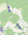
Ironically, EE have a similar setup, yet end up with terrible coverage. Potentially because of them only using 2 degrees of downtilting on the radio panels, meaning it's not really aimed towards the tunnel well enough to be effective.

1714066963773.png
 

infobleep

Veteran Member
Joined
27 Feb 2011
Messages
12,676
See Post 48: https://www.railforums.co.uk/threads/brighton-mainline-4g-5g-upgrades.243539/page-2#post-6415267

This is just one specific example of good tunnel coverage.

Ironically, EE have a similar setup, yet end up with terrible coverage. Potentially because of them only using 2 degrees of downtilting on the radio panels, meaning it's not really aimed towards the tunnel well enough to be effective.

View attachment 157056
Fascinating. I must have forgotten that post from Septemeber 2023.
 

dastocks

Member
Joined
3 Nov 2021
Messages
176
Location
Hove
On my trip down that line last week, my train to Brighton didn't have any internet assess at all (Thameslink) despite attempting to connect to it. Fully working though when I returned, so puzzled as to why the former occured? Is it something to do with the train or the signal?
My general experience with the wi-fi on Thameslink is that it's piss-poor at best and frequently not working at all. I had a slightly weird experience the other day when a 'Great Northern' wi-fi popped up at Brighton, and it seemed to work. I think I was on a GX flavoured train.
 

MrJeeves

Established Member
Joined
28 Aug 2015
Messages
1,995
Location
Burgess Hill
Don't quote me on this, but I think the site near Haywards Heath which I mentioned back in post 13 may be live now on EE?

There's a new site on CellMapper which I've mapped a few times over the last week but the location is a bit dodgy at the moment.
Wasn't the Cellnex site.

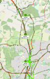
Another additional site effectively adjacent to Copyhold Jn (43018 in the image below):

1714086160405.png
 

Gigabit

Member
Joined
7 Dec 2022
Messages
187
Location
United Kingdom
Wasn't the Cellnex site.

Another additional site effectively adjacent to Copyhold Jn (43018 in the image below):

View attachment 157076

So this is a new site EE have built to improve coverage seperate to the main scheme?

Coverage doesn’t look too terrible on the map there, would red indicate unacceptable or would that be okay from the MNO point of view do we know?
 

MrJeeves

Established Member
Joined
28 Aug 2015
Messages
1,995
Location
Burgess Hill
So this is a new site EE have built to improve coverage separate to the main scheme?

Coverage doesn’t look too terrible on the map there, would red indicate unacceptable or would that be okay from the MNO point of view do we know?
Yeah, new site separate to the Cellnex scheme.

The colour just represents signal strength (RSRP), and nothing about usability. This area has always had a lack of usable internet on EE for me, so it's a welcome change (even if I've not noticed any immediate improvements because I didn't know where/when to look!)

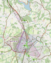
Worth remembering that the coverage stretches well beyond the range of the railway line, too. The polygons in the image below detail where signal has been recorded through the Cellmapper Android app from this particular site (almost all of the data from me I think :D).

1714144920572.png

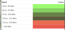
The colour scale is below, but I'd personally say anything red would be unacceptable for a major railway line. The coloured pixels on the Cellmapper map represent the highest signal level ever recorded in that specific location.

1714145110092.png
 

Gigabit

Member
Joined
7 Dec 2022
Messages
187
Location
United Kingdom
Yeah, new site separate to the Cellnex scheme.

The colour just represents signal strength (RSRP), and nothing about usability. This area has always had a lack of usable internet on EE for me, so it's a welcome change (even if I've not noticed any immediate improvements because I didn't know where/when to look!)

Worth remembering that the coverage stretches well beyond the range of the railway line, too. The polygons in the image below detail where signal has been recorded through the Cellmapper Android app from this particular site (almost all of the data from me I think :D).

View attachment 157128

The colour scale is below, but I'd personally say anything red would be unacceptable for a major railway line. The coloured pixels on the Cellmapper map represent the highest signal level ever recorded in that specific location.

View attachment 157129

So has the map just not updated yet as looks like a bit of red even around the new site?

I would be interested to know what Cellnex will be targeting for their sites in order to achieve the "uninterrupted" promise, whatever that means.

It looks like even in this area there would be a lot more sites needed?

Also @MrJeeves I think I've found your site: https://www.google.co.uk/maps/@51.0221176,-0.1081219,39m/data=!3m1!1e3?entry=ttu.
 

MrJeeves

Established Member
Joined
28 Aug 2015
Messages
1,995
Location
Burgess Hill
So has the map just not updated yet as looks like a bit of red even around the new site?
Or my phone's GPS didn't record in the same exact location as that red. Or (as the app can only record, say, one data point every second) it didn't record a data point exactly as I passed over that point.

But yes, the maps generally update every week or two compared to the actual data which updates almost instantly when uploaded by members with a premium (CAD$3/mth) subscription.

Yep, that's the one :p

I found it through the Mid Sussex planning portal map (it's not got an application, but does have a property marked on the map).
 

Top