• Our booking engine at tickets.railforums.co.uk (powered by TrainSplit) helps support the running of the forum with every ticket purchase! Find out more and ask any questions/give us feedback in this thread!

Century old LNER wagon unearthed in field near Antwerp

WesternLancer

Established Member
Joined
12 Apr 2019
Messages
7,186
A photo (from an LNER staff magazine) on David Turner's FB page shows a very similar furniture container in Antwerp itself.
Antwerp was a ferry destination from Harwich.

Nice link - with a railway cat theme too!

Could it have been buried as a quick method of providing an Air raid shelter during WW2?
I recall that some current RAF Bases used covered Bulk skips as a way of providing bomb shelters in remote areas of airfields.
I'd not have thought of that - but it seems almost anything might be possible! So with that in mind you can't rule out such an idea perhaps.
 
Sponsor Post - registered members do not see these adverts; click here to register, or click here to log in
R

RailUK Forums

StephenHunter

Established Member
Joined
22 Jul 2017
Messages
2,148
Location
London
I wouldn't have fancied my chances in that box of plywood and timber, against Jerry's bombs...
A lot of the smaller shelters of that time, like this one, wouldn't protect you against a direct hit, but would offer some protection against a reasonably close detonation. Bombing accuracy wasn't that great at all from high altitude and the stuff that could achieve close accuracy like the Stuka tended to have only a few small bombs.
 

Gloster

Established Member
Joined
4 Sep 2020
Messages
8,440
Location
Up the creek
A lot of the smaller shelters of that time, like this one, wouldn't protect you against a direct hit, but would offer some protection against a reasonably close detonation. Bombing accuracy wasn't that great at all from high altitude and the stuff that could achieve close accuracy like the Stuka tended to have only a few small bombs.

Unfortunately, that meant that the bombs supposedly aimed at the factory a mile away landed on you instead. The shelters were of some use, but nothing except a deep one would protect you against a direct hit. A shelter in the garden would at least protect you from falling debris, splinters and blast; even the dining room table might protect you if the house was demolished by a near miss.

Not having seen the photos, the container might have been used to provide the basic walls around which earth ramparts were built, but it strikes me as an unsuitable shape to be used: better just use the timber. For that matter, I don’t think that civilian ARP arrangements in Belgium developed anything like as much after the country was invaded.
 

stuving

Member
Joined
26 Jan 2017
Messages
266
Having looked at several local news items on this, even with a translator that really doesn't like Dutch, some things become a bit clearer.

This wasn't dug up last week, it was earlier in the year - probably January.

The area is not a field near Antwerp, it's named as Oosterweel or Noordkasteel, in the docks beside the Scheldt. Does anyone have any information on where LNER's depot or quayside yard was?

The area has long been industrial, with this bit not redeveloped recently for new industry. The container was found buried in a "wal" - rendered as rampart, though I suspect bank or embankment might be closer. The area is being cleared to build a road junction, part of the Antwerp ring, which will be below ground level.

This picture shows what it's sitting on - a concrete slab, I think. I suspect this is where it's been since 1940 - not buried as a chosen act, but left in situ when the earth was banked up around it.

Why 1940? Because LNER would have left then. Maybe this container went across before the war, and was kept in case someone needed it there, or was sent during the Phoney War as planning for a British evacuation, or something more unguessable. In any case, the speed of the German invasion was such that pre-planning didn't count for a lot.

These containers were built to be craned on and off flat wagons and lorries, and were also taken on ships as deck cargo. That became more common after the war, and with railways no longer the main companies doing it, but was not unknown before the war. So going to Belgium did not depend on a rail connection by ferry.
b95fb2dc-e5d7-11ee-b483-02b7b76bf47f.jpg
 

randyrippley

Established Member
Joined
21 Feb 2016
Messages
5,137
Antwerp docks was extensively damaged by the Germans as they retreated in 1944, including sea wall destruction. Later they attacked it with a severe V2 bombardment.
In view of the comment above about a "wal", I wonder if that was an old sea wall? Given the desperation the Allies were in to get the docks functional, I can see something like this, stuffed full of sand, being used as a makeshift plug in a damaged sea wall or canal bank.
If it was just lying around, it would have got grabbed and used.
 

30907

Veteran Member
Joined
30 Sep 2012
Messages
18,062
Location
Airedale
Antwerp docks was extensively damaged by the Germans as they retreated in 1944, including sea wall destruction. Later they attacked it with a severe V2 bombardment.
In view of the comment above about a "wal", I wonder if that was an old sea wall? Given the desperation the Allies were in to get the docks functional, I can see something like this, stuffed full of sand, being used as a makeshift plug in a damaged sea wall or canal bank.
If it was just lying around, it would have got grabbed and used.
That seems a plausible suggestion as to why the container ended where it did: various online dictionaries give "wal" as a rampart/embankment/mound/floodbank.
There would be nothing particularly odd about an LNER container in an LNER continental port pre 1940, nor about it being part of an emergency dyke repair or similar.

(Note - Wal can apparently just mean "shore" but this looks like intentional placing rather than something washed up. Perhaps our NL readers have a view?)
 

randyrippley

Established Member
Joined
21 Feb 2016
Messages
5,137
Doing some digging on maps
First this Google maps shot shows the area where the box was found - Oosterwheel / Nordkasteel in the centre

Second it appears that in 1935 the LMS invested all its North Sea shipping assets into a joint venture with the other rail companies: Associated Humber Lines. I've found one reference which says this used the Quai d' Sud in Antwerp - which I presume is the area marked as Scheldt docks south in this shot

Not so far away

This third map gives an indication of where the British forces were headquartered during the battle for the Scheldt
The British HQ was nearby
The fourth map gives an idea of the complexity of the military movement during the battle
ostyn-antwerp-map[1].jpg

Below bottom is the fourth map
Both were taken from this website

The historic city of Antwerp lies 80 Km from the North Sea on the Scheldt River. The river Scheldt flows into the Dutch Schelde called Westerschelde. On the northern embankment of the Scheldt (Schelde) lies Noord Brabant, then the South Beveland and Walcheren peninsulas. The port is one of the Europe's great harbors, but it is not a natural harbor. Its docks were dug out and fitted with locks to regulate the water and allow transportation of goods further inland. Following D-Day, June 6, 1944, the Allies had enormous resources while German materials were shrinking. During the early days of the assault in Normandy, the German forces had managed to limit the supplies and ammunition that could come ashore by keeping the front narrow and denying the Allies the use of any of the French ports. American forces captured Cherbourg on June 27, 1944, but the Germans had done such an efficient job of demolition that the port did not open until July 19, 1944.

Following "Operation Cobra" the German positions in Normandy gave way. Racing to the Seine, the Allies were met at Mortain by a German counter-attack on August 6, 1944. The Allies used the opportunity to surround the German forces in the “Falaise Pocket,” destroying thousands of vehicles and killing or capturing more than 10,000 German troops. By August 25 the battle was ended and Paris was liberated the same day. German resistance west of the Seine River collapsed. Allied armies pushed forward in pursuit, crossing the river before the Germans could reorganize. The rapid movement of the Allied troops meant they were getting farther away from their supply lines. These supplies were still offloading in Normandy, over 500 miles distant. This led to shortages in critical supplies such as fuel and ammunition. British and American forces were forced to ration the resources—something that was very disagreeable to both.

The importance of the port to the Allies can be summed up in a message Eisenhower wrote to General Marshall on October 23, 1944 stating that "the logistical problem has become so acute that all plans had made Antwerp sine qua non to the waging of the final all-out battle." At the time, US Army doctrine called for the use of railways to transport large amounts of cargo whenever possible. However, because Allied bombers had destroyed so much of the French rail system during 1943-44, this wasn't possible. As the Allies worked to repair the railroads, supplies were being landed, but they were being stockpiled on the beaches and docks in Normandy. This backlog led to the implementation of a short-term fix using trucks to operate one-way circular routes to supply US troops. Several trucking operations were formed, one of which was the famous "Red Ball Express." In total, 141 truck companies were called, but there were not enough trucks available.
 

Attachments

  • scheldt-map[1].jpg
    scheldt-map[1].jpg
    1.3 MB · Views: 9
Last edited:

stuving

Member
Joined
26 Jan 2017
Messages
266
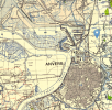
NLS have WW2 British military maps of Belgium, but they are small scale ones and based on WW! originals with an unknown amount of revision. So this one, while dated 1943-44, should be seen as pre-war but of no specific date. (Ignore the pointer - it's not where I put it on the map!)
1711291714522.png
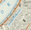
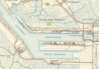
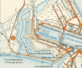
I have found a larger scale map in Belgian Archives, it must be the first post-war mapping, from 1948 aerial photographs (and it's stamped "SECRET"!) It is much larger scale, so much so it can't be sensibly shown in full. So here are three small excerpts:
The Zuid-Schippers Dokken looks a bit small - an old city centre dock, like St Katharine's in London, and since filled in. At 75m at its widest, it might be too narrow to turn a channel ferry.
1711291741064.png
Later on, you'd expect to find ramp-loading ferries in something like the Hansadok. Of course at this date the Antwerp channel ferries berthed alongside, so you might not see anything diagnostic on a map.
1711291770460.png
The area around Noordkasteel was not yet industrial, it still contained the ramparts and moats of the eponymous fortress. But of course we don't where in that general area it was. The Dutch/Belgian reports mention the space being used for sports facilities between then and now, and suggest the container might have been taken there for use in connection with that. It would presumably have got buried under the raised river wall or a road embankment, being seen as not even worth moving out of the way.
1711291800019.png
 
Last edited:

30907

Veteran Member
Joined
30 Sep 2012
Messages
18,062
Location
Airedale
Photos here of the berth at "Quai d'Herbouville/du Sud"
https://www.flickr.com/photos/146235845@N05/37643501314/in/photostream/
https://www.bridgemanimages.com/en/...photo/black-and-white-photograph/asset/814732
The second image confirms the impression of the first that the berth was on the river itself, a little upstream of the Suid-Schippers-Dokken.

And an interesting document by K Westcott Jones (a railway and travel author, but the address suggests a family business in Antwerp itself).
https://oudedokken.gilbertus.com/documents/extrazien.php?id=Harwich
 

stuving

Member
Joined
26 Jan 2017
Messages
266
Photos here of the berth at "Quai d'Herbouville/du Sud"
https://www.flickr.com/photos/146235845@N05/37643501314/in/photostream/
https://www.bridgemanimages.com/en/...photo/black-and-white-photograph/asset/814732
The second image confirms the impression of the first that the berth was on the river itself, a little upstream of the Suid-Schippers-Dokken.

And an interesting document by K Westcott Jones (a railway and travel author, but the address suggests a family business in Antwerp itself).
https://oudedokken.gilbertus.com/documents/extrazien.php?id=Harwich
Yes, that does answer the question about where LNER ferries docked. The D'Herbouvillekaai is roughly over the Kennedytunnel, near the southern limit of the old city. But far (ca. 4 km) from where this container is now - it must at some stage have been worth moving, and then not worth recovering when it got buried.

Some of that Westcott Jones piece is puzzling - C.H. Farkes for C.H.Parkes and Farkeston for Parkeston must be typo-by-OCR, but Great Western Railway for Great Eastern Railway?

PS:actually that could be OCR as well - if it's trained on word likelihoods too much. The curse of AI! (Even if this isn't AI really.)
 
Last edited:

Top