• Our new ticketing site is now live! Using either this or the original site (both powered by TrainSplit) helps support the running of the forum with every ticket purchase! Find out more and ask any questions/give us feedback in this thread!

Longest line of sight (UK)

nw1

Established Member
Joined
9 Aug 2013
Messages
8,273
At certain times, Plynlimon in the Cambrian Mountains is visible from Mow Cop. The possible panorama from the top of Plynlimon is quite wide-ranging. I am always amazed by what possible extreme vistas can be seen from one spot. With Plynlimon, it is possible in the right conditions to see south-east Ireland in one direction and Derbyshire/Staffordshire/Worcestershire in another direction.

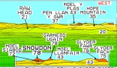
Similar too with the top of Snowdon - being able to see south-east Ireland in one direction and North Yorkshire in another direction.

Plynlimon always strikes me as a 'hidden' upland because I've only ever seen it from very close range, somewhere near Devil's Bridge.

I guess the fact it's a plateau means it's hard to pick out from a distance if there are other large and more prominently-shaped hills in front of it. Never been there but isn't it somewhat reminiscent of parts of Dartmoor (in the sense that it's a plateau rather than a peak)?

Worcestershire Beacon (going back to that again) must be another one - if it is indeed true you can see Kinder Scout from there, and also Uffington White Horse Hill (which I think is true), that makes it perhaps the only place in the UK from which you can see both "northern" and "southern" England (using a definition, admittedly my own, of "the North" beginning at the Dark Peak, as the Dark Peak has that "gritty northern-ness" quite unlike the softer White Peak which to me is Midlands) and "the South" having its northern limit at the Ridgeway path.
 
Last edited:
Sponsor Post - registered members do not see these adverts; click here to register, or click here to log in
R

RailUK Forums

Altrincham

Member
Joined
22 Aug 2011
Messages
266
Plynlimon always strikes me as a 'hidden' upland because I've only ever seen it from very close range, somewhere near Devil's Bridge.

I guess the fact it's a plateau means it's hard to pick out from a distance if there are other large and more prominently-shaped hills in front of it. Never been there but isn't it somewhat reminiscent of parts of Dartmoor (in the sense that it's a plateau rather than a peak)?

Worcestershire Beacon (going back to that again) must be another one - if it is indeed true you can see Kinder Scout from there, and also Uffington White Horse Hill (which I think is true), that makes it perhaps the only place in the UK from which you can see both "northern" and "southern" England (using a definition, admittedly my own, of "the North" beginning at the Dark Peak, as the Dark Peak has that "gritty northern-ness" quite unlike the softer White Peak which to me is Midlands) and "the South" having its northern limit at the Ridgeway path.
I like to think that this is actually possible - to see Uffington White Horse Hill from Worcestershire Beacon. It looks like a line of sight would pan across the tops of the Cotswolds, with possibly Cleeve Hill in the way. But I do like the thought of a viewpoint where it is possible to see both northern and southern England.
 

DelW

Established Member
Joined
15 Jan 2015
Messages
4,702
On Wednesday, I was sitting on the hillside behind the western beach at New Quay in Ceredigion. As the mistiness out at sea cleared, we could see progressively further up the coast until the Lleyn Peninsula hills were visible across the northern horizon. To the right of those, and fainter, was a definite flattish-conical peak, above the others, which I think must have been Snowdon. If so, Google maps gives a distance of exactly 60 miles.
Unfortunately I only had a little compact camera with me which wouldn't have captured anything useful.
 

Altrincham

Member
Joined
22 Aug 2011
Messages
266
On Wednesday, I was sitting on the hillside behind the western beach at New Quay in Ceredigion. As the mistiness out at sea cleared, we could see progressively further up the coast until the Lleyn Peninsula hills were visible across the northern horizon. To the right of those, and fainter, was a definite flattish-conical peak, above the others, which I think must have been Snowdon. If so, Google maps gives a distance of exactly 60 miles.
Unfortunately I only had a little compact camera with me which wouldn't have captured anything useful.
It does indeed look like it was Snowdon that you could see from New Quay, according to the Hey What’s That site (the visibility cloak covers Snowdon and the Glyders).

DA9CBD6D-AC8A-43F9-9920-CC8C4072452C.png
 
Joined
23 Mar 2021
Messages
51
Location
Yeovil
I recently watched contrails on a flight from London to Antigua Go past Yeovil where I live and was suprised to follow on flight radar as it went past the North Cornwall coast near Bude 83 miles from me.
 

Altrincham

Member
Joined
22 Aug 2011
Messages
266
Took a trip this afternoon to the top of Mow Cop, a spot that sits right on the Cheshire and Staffordshire border (about 1,100 feet above sea level). I remembered this time to take my binoculars with me.

Reasonable visibility with the naked eye was about 45 to 50 miles and the Clwydian Range was clear to see, along with Cannock Chase, Wrekin, the Long Mynd, and also hills in Powys.

Very good views across the Cheshire Plain.

Through the binoculars, I saw something that I thought was always hard to see. I saw Snowdon from Mow Cop.

A good zoom camera is what I need to capture this in picture form. With a bit of perseverance today (plus the trusty Viewfinder Panorama), the hazy mass of Snowdonia was visible through binoculars from Mow Cop.

Using Beeston Castle in Cheshire as a reference point, there were visible-but-hazy masses well beyond the Clwydian Range. Glyder Fawr and Glyder Fach were easily made out, and then a short pan south showed Garnedd Ugain, and then Snowdon.

Quite hazy yet discernible, and matched this view here:

91A27BF6-D542-4A16-BD7F-ED43CE837E78.jpeg

Other points that were picked up through my binoculars from Mow Cop today:

The skyline of Manchester city centre (with Scout Moor wind farm as a backdrop)
Barton Bridge
The Trafford Centre
Transmitters on Winter Hill
Jodrell Bank’s central antenna (the dish was facing south-west today)
The ICI works at Northwich
Fiddler’s Ferry power station at Widnes
Liverpool city skyline (cathedrals, radio tower, and flats)
Cranes at Seaforth docks
Chimneys at Stanlow refinery
Smallwood Vintage Rally near Sandbach
Beeston Castle
The sun glinting on objects on the Clwydian hills
Cannock Chase and neighbouring transmitters
Weaver Hills
 

Attachments

  • AC2DA220-7E68-4E54-80AB-3E0268654B75.jpeg
    AC2DA220-7E68-4E54-80AB-3E0268654B75.jpeg
    1.1 MB · Views: 7

Scotrail314209

Established Member
Joined
1 Feb 2017
Messages
2,444
Location
Edinburgh
On the bus to North Berwick right now, pretty incredible to look down the coast and see the Forth Bridge peeking out (albeit faintly).

The skyline of Edinburgh is visible too.

Will add pictures later on.
 

route101

Established Member
Joined
16 May 2010
Messages
11,277
On the bus to North Berwick right now, pretty incredible to look down the coast and see the Forth Bridge peeking out (albeit faintly).

The skyline of Edinburgh is visible too.

Will add pictures later on.
Some great lines of sight along the East Coast. Pretty sure you can see from Angus down to England.
 

Altrincham

Member
Joined
22 Aug 2011
Messages
266
I saw a really good coastal line of sight 2 weeks ago when I was travelling by train on a Sunday evening between Colwyn Bay and Abergele. Sat clearly on the north-east horizon across Liverpool Bay was Winter Hill, and then just a bit further round to the north I saw what looked like the hills of the southern Lake District.

I think there had just been a downpour out in the bay, which left really clear visibility across to England from sea level in North Wales.
 

Altrincham

Member
Joined
22 Aug 2011
Messages
266
The current weather conditions have meant there have been some good westward lines of sight, especially over water or after sunset. After-sunset has produced some great long-distance vapour trails. I was in south Derbyshire on Monday night (around Derby where there the outlying areas are really flat) and looking westward saw a trail that was quite some way away, and heading west, but illuminated brilliantly. A check on FlightRadar24 showed that it was a BA service operating London City to Dublin and was high over the Wirral.

Last night I was driving through Bucklow Hill, which is an elevated position between Knutsford and Altrincham, in a prolonged dusk and had a clear view of the transmitter lights of Winter Hill, plus also a shimmering view of the transmitter lights of Holme Moss in West Yorkshire.

I do love this time of year when the sky is so light late on, with the added advantage of some good low pressure conditions for clear visibility.

Today was also very clear from South Stack on Anglesey where there was a great view across towards the Wicklow Mountains, as seen in this picture taken by the Anglesey History Facebook group.

330A6BF9-4A62-4E5E-830B-0A59AC9EC7AC.jpeg
 

Howardh

Established Member
Joined
17 May 2011
Messages
9,103
The current weather conditions have meant there have been some good westward lines of sight, especially over water or after sunset. After-sunset has produced some great long-distance vapour trails. I was in south Derbyshire on Monday night (around Derby where there the outlying areas are really flat) and looking westward saw a trail that was quite some way away, and heading west, but illuminated brilliantly. A check on FlightRadar24 showed that it was a BA service operating London City to Dublin and was high over the Wirral.

Last night I was driving through Bucklow Hill, which is an elevated position between Knutsford and Altrincham, in a prolonged dusk and had a clear view of the transmitter lights of Winter Hill, plus also a shimmering view of the transmitter lights of Holme Moss in West Yorkshire.

I do love this time of year when the sky is so light late on, with the added advantage of some good low pressure conditions for clear visibility.

Today was also very clear from South Stack on Anglesey where there was a great view across towards the Wicklow Mountains, as seen in this picture taken by the Anglesey History Facebook group.

View attachment 116320
Magnificent!
 

DerekC

Established Member
Joined
26 Oct 2015
Messages
2,287
Location
Hampshire (nearly a Hog)
I really like the West Dorset area and regularly walk up the local hills there. The "PeakVisor" app suggests that Pen-y-van in the Brecon Beacons should be visible from Pilsdon Pen (the second highest point in Dorset) given sufficiently clear air, at a range of 128.8 km (80.5 miles). This seems to be possible because the sight line goes across the Somerset Levels. I will be looking out next time I go up there in clear weather. I have a compass app in my mobile phone and a small pair of binoculars. Is this really plausible? Any advice appreciated.
 

Altrincham

Member
Joined
22 Aug 2011
Messages
266
I really like the West Dorset area and regularly walk up the local hills there. The "PeakVisor" app suggests that Pen-y-van in the Brecon Beacons should be visible from Pilsdon Pen (the second highest point in Dorset) given sufficiently clear air, at a range of 128.8 km (80.5 miles). This seems to be possible because the sight line goes across the Somerset Levels. I will be looking out next time I go up there in clear weather. I have a compass app in my mobile phone and a small pair of binoculars. Is this really plausible? Any advice appreciated.
I think your theory and description of this view is spot-on. The excellent Viewfinder Panorama site has a panorama for Pen y Fan and, looking south-south-east, Pilsdon Pen is visible at a distance of 79 miles.


Actually, looking at the northern vista from Pen y Fan, it has a line of sight to Snowdonia. So if the conditions were right, it could be possible from the top of Pen y Fan to see Dorset in one direction and Snowdonia in the other direction.


nw1

Established Member
Joined
9 Aug 2013
Messages
8,273
I think your theory and description of this view is spot-on. The excellent Viewfinder Panorama site has a panorama for Pen y Fan and, looking south-south-east, Pilsdon Pen is visible at a distance of 79 miles.


Actually, looking at the northern vista from Pen y Fan, it has a line of sight to Snowdonia. So if the conditions were right, it could be possible from the top of Pen y Fan to see Dorset in one direction and Snowdonia in the other direction.

So from far southern England - Pilsdon Pen is not far from the coast - to north Wales, quite some distance. An effect of Pen-y-Fan being by far the highest land in the area. As an aside, you'd have to go quite some way to find higher ground to west (Ireland), south (Pyrenees?), and east (Urals??) I suspect.
 

davehsug

Member
Joined
8 Jul 2014
Messages
296
So from far southern England - Pilsdon Pen is not far from the coast - to north Wales, quite some distance. An effect of Pen-y-Fan being by far the highest land in the area. As an aside, you'd have to go quite some way to find higher ground to west (Ireland), south (Pyrenees?), and east (Urals??) I suspect.
Pretty close, but I think the Massif Central has plenty of peaks higher than the Beacons before you get to the Pyrenees.
 

nw1

Established Member
Joined
9 Aug 2013
Messages
8,273
Pretty close, but I think the Massif Central has plenty of peaks higher than the Beacons before you get to the Pyrenees.

True (as the highest peaks are around 1900m) but that is someway to the east, the westernmost high peaks being around the longitude of Paris. I was thinking more of heading due south, more or less, from South Wales. There is some high ground in Normandy and Brittany but that is around 400-500m or so, and thus not as high as Pen-y-Fan.
 

davehsug

Member
Joined
8 Jul 2014
Messages
296
True (as the highest peaks are around 1900m) but that is someway to the east, the westernmost high peaks being around the longitude of Paris. I was thinking more of heading due south, more or less, from South Wales. There is some high ground in Normandy and Brittany but that is around 400-500m or so, and thus not as high as Pen-y-Fan.
Ah yes, sorry for misunderstanding, How high are the mountains in Ireland are they higher than the Beacons? If not, you might have to get to the Canadian Rockies if you headed due west!
 

nw1

Established Member
Joined
9 Aug 2013
Messages
8,273
Ah yes, sorry for misunderstanding, How high are the mountains in Ireland are they higher than the Beacons? If not, you might have to get to the Canadian Rockies if you headed due west!

Some are rather higher, particularly the Kerry mountains to the southwest which exceed 1000m and must be approximately due west of the Beacons.
 

eMeS

Member
Joined
12 Jun 2011
Messages
954
Location
Milton Keynes, UK
As a long time DSLR camera user with an interest in long distance vistas, I can recommend a Canon 7D MkII (with built-in GPS & compass) or Canon 5Ds with external add-on GP-E2 (GPS & compass). There's also special viewing applications on the web - GeoSetter works well for me, and this shows both horizontal field of view, as well as direction pointed at. The 5Ds with external GP-E2 seems to acquire satellites more quickly than my earlier 7D MkII.

In general, both cameras have worked well once the GPS has found its satellites, but one problem I have run into is errors in the compass info from, I assume, local magnetic field effects. (Any ideas welcome! How does one recognise magnetic rock? With a hand-compass?)
 

Scotrail314209

Established Member
Joined
1 Feb 2017
Messages
2,444
Location
Edinburgh
Not a long line of sight per say, but there is something remarkable about being on the Campsies and seeing the entire sprawl of Greater Glasgow beneath you. I was at the top of one of the peaks and was able to just make out the city centre through a long camera lens. It was slightly hazy, but what was clear was seeing the steeple at Glasgow University and the light reflecting off Glasgow Tower at the Science Centre.

One thing I want to do is head up to Tak Ma Doon Road, where on a good day you can see much of Central Scotland, including Fife, Greater Glasgow, the Forth River, Grangemouth and the Forth Bridges. No idea if you can see Edinburgh, would be remarkable if you could see both Glasgow and Edinburgh at one time.
 

Strathclyder

Established Member
Joined
12 Jun 2013
Messages
3,436
Location
Clydebank
Not a long line of sight per say, but there is something remarkable about being on the Campsies and seeing the entire sprawl of Greater Glasgow beneath you. I was at the top of one of the peaks and was able to just make out the city centre through a long camera lens. It was slightly hazy, but what was clear was seeing the steeple at Glasgow University and the light reflecting off Glasgow Tower at the Science Centre.
While not in the same league as the Campsies, being able to see most of Glasgow and Paisley from the hills in/around the eastern edge of Faifley on the 'other' side of the Clyde on a clear night is quite something. The one that my flat sits at the foot of allows for views stretching from the Erskine Bridge, Paisley/Glasgow Airport, a good chunk of Glasgow and it's suburbs (Milton's six tower blocks are readily visible for instance) and as far afield as Cathkin, Springburn and, on clear days and standing in just the right spot, I think I've made out Cumbernauld's remaining tower blocks.
 

najaB

Veteran Member
Joined
28 Aug 2011
Messages
32,283
Location
Scotland
Also in the "not particularly long, but impressive none the less" category, standing on Dundee Law and seeing the Bell Rock lighthouse. I do have a photo somewhere, need to dig it out, but the line of sight would be this:

Google Maps screenshot showing 38km distance from Dundee Law to the Bell Rock
 

Taunton

Established Member
Joined
1 Aug 2013
Messages
11,098
No idea if you can see Edinburgh, would be remarkable if you could see both Glasgow and Edinburgh at one time.
It's actually not that far, 47 miles by rail; being about equidistant between them on a high point should be straightforward to see both, especially Arthur's Seat. I do notice on a plane from London approaching Glasgow airport, descending over Baillieston and the edge of the Campsies, it is normal to see the Forth Bridges and Edinburgh airport.
 

route101

Established Member
Joined
16 May 2010
Messages
11,277
I am not sure where you can see Edinburgh and Glasgow from the same viewpoint, somewhere near Shotts perhaps.
 

McRhu

Member
Joined
14 Oct 2015
Messages
564
Location
Lanark
I am not sure where you can see Edinburgh and Glasgow from the same viewpoint, somewhere near Shotts perhaps.
I'm sure I can remember seeing the Forth Bridges to the East and Glasgow to the West from somewhere near the summit of Newmill and Canthill Road, from Kirk o' Shotts to Shotts. The air was clearer back in the 80s certainly when I used to frequent this route. Also the summit at Dewshill on the B7066 between Salsburgh and Harthill. (BT had/have microwave dishes there, beaming to Greenlowter.)
 

Scotrail314209

Established Member
Joined
1 Feb 2017
Messages
2,444
Location
Edinburgh
Hello, could anyone help me identify these very distant peaks behind the Queensferry crossing?

Zoomed in version also attached highlighting the ones I mean

First image shows Queensferry Crossing and a range of hills behind it

Second image shows the same picture but zoomed in with the distant peaks highlighted.
 

Attachments

  • C16B39E4-7F0B-4E90-9A92-2C3856E5A821.jpeg
    C16B39E4-7F0B-4E90-9A92-2C3856E5A821.jpeg
    1.1 MB · Views: 44
  • 75E618A8-C954-4C81-B01D-9AC154553385.jpeg
    75E618A8-C954-4C81-B01D-9AC154553385.jpeg
    846.8 KB · Views: 44

MacCookie

Member
Joined
22 Oct 2010
Messages
219
Hello, could anyone help me identify these very distant peaks behind the Queensferry crossing?

Zoomed in version also attached highlighting the ones I mean

First image shows Queensferry Crossing and a range of hills behind it

Second image shows the same picture but zoomed in with the distant peaks highlighted.
Peak on the left is Ben Ledi, while on the right you've got Dumyat in the foreground with Stuc a'Chroin behind on the left and Ben Vorlich on the right.

Cheers,
Ewan
 

181

Member
Joined
12 Feb 2013
Messages
865
Here's a closer view of Ben Ledi from a similar direction: https://commons.wikimedia.org/wiki/...cardine_Bridge_-_geograph.org.uk_-_470323.jpg.

I'm not sure about the others -- Stuc and Ben Vorlich sound plausible, but by the admittedly rather crude method of putting a ruler on the 1:200,000 map, it appears that Stuc would only be to the left of Dumyat if your viewpoint was to the south of the Edinburgh built-up area, too far south to see Ben Ledi over the end of the bridge. Maybe Beinn Each to the left and Stuc to the right? But on the other hand, you'd then expect to see Ben Vorlich to the right of Stuc, and there doesn't appear to be a third mountain in the photo.

Here is the view from Ben Vorlich, if that helps to see whether it includes your viewpoint: http://viewfinderpanoramas.org/panoramas/GRW/VORLICH-E-S.gif.

And here is the view from Arthur's Seat: http://viewfinderpanoramas.org/panoramas/CEN/ARTHUR.GIF -- were you anywhere near that? That makes me wonder whether you were seeing Stob Binnein and Ben More, although the shapes don't look pointed enough in the picture.
 

Top