• Our new ticketing site is now live! Using either this or the original site (both powered by TrainSplit) helps support the running of the forum with every ticket purchase! Find out more and ask any questions/give us feedback in this thread!

Major / trunk roads built upon former railway routes?

Sun Chariot

Established Member
Joined
16 Mar 2009
Messages
3,352
Location
2 miles and 50 years away from the Longmoor Milita
Numerous urban roads and guided busways, in the UK, have been constructed upon the alignment of former railway lines.

However, I am curious to learn of which M- or A- trunk roads (incl bypasses) have been laid along former railway routes?

Example:
The M90 uses some of the former Glenfarg route. It was the North British' Railway's most direct route between Edinburgh and Perth, running from Cowdenbeath to Kinross. Engineered for express speeds, the route was a double-track main line.

The A7 Edinburgh to Carlisle road follows closely to some of the former Waverley line; however, to my knowledge, none of the A7 is actually built on the old railway alignment; so it falls outside the scope of this thread.

Which others do you know of / have driven?
 
Last edited:
Sponsor Post - registered members do not see these adverts; click here to register, or click here to log in
R

RailUK Forums

John Webb

Established Member
Joined
5 Jun 2010
Messages
3,430
Location
St Albans
There is a lengthy stretch of the A66 from west of Keswick to just east of Cockermouth which mostly uses the trackbed of the former railway line between those two towns.
 

zwk500

Veteran Member
Joined
20 Jan 2020
Messages
14,944
Location
Bristol
Doesn't the M25 use the former Westerham branch alignment between just west of Junction 5?

The A22 severs the Lewes-Uckfield line just outside Uckfield with an embankment across the formation (and an alleged promise to fund a bridge if need be, which curiously nobody at the council can find any record of), but as that's perpendicular not parallel to the centreline of the railway perhaps not what you were thinking of?
 

PeterC

Established Member
Joined
29 Sep 2014
Messages
4,365
The previous alignment of the A120 (now B1256) used the alignment of the Braintree to Bishops Stortford line to bypass Dunmow town centre.
 

Ashley Hill

Established Member
Joined
8 Dec 2019
Messages
4,045
Location
The West Country
Part of the North Devon link road (A361) is built in the GWR Barnstaple - Taunton line. It even uses the pillars of Castle Hill viaduct.
 

Sir Felix Pole

Established Member
Joined
21 Oct 2012
Messages
1,316
Location
Wilmslow
The M55/A5230/Yeadon Way main access route into Blackpool, partially uses the Marton Direct Line which ran into the old Central station.
 

pnepaul

Member
Joined
11 Sep 2012
Messages
134
Location
Carlisle
The A685 from just outside Tebay heading east uses the former Stainmore route ( as far as Newbiggin (?) )
 

D6130

Established Member
Joined
12 Jan 2021
Messages
7,208
Location
West Yorkshire/Tuscany
The A828 Connel Ferry to Ballachulish road follows the old railway alignment across the Connel and Creagan (Loch Creran) bridges....although, in fairness, the Connel bridge was always bi-mode (rail and road) when the railway was open between 1903 and 1966. The road has also been widened across - or diverted onto - the old railway formation at several other points on the route.
 

Magdalia

Established Member
Joined
1 Jan 2022
Messages
4,720
Location
The Fens
Three important roads in the Fens are on old railways:

A141 Chatteris-March
A17 Kings Lynn-Sutton Bridge
A16 Spalding-Boston
 

Sun Chariot

Established Member
Joined
16 Mar 2009
Messages
3,352
Location
2 miles and 50 years away from the Longmoor Milita
Doesn't the M25 use the former Westerham branch alignment between just west of Junction 5?

The A22 severs the Lewes-Uckfield line just outside Uckfield with an embankment across the formation (and an alleged promise to fund a bridge if need be, which curiously nobody at the council can find any record of), but as that's perpendicular not parallel to the centreline of the railway perhaps not what you were thinking of?
Re: M25 - yes, I think you're right. I forgot that I had watched YouTube "Auto Shenanigans" about that very topic.
The old station master's house is off to the side of the M25's boundary.
I can't recall if the M25 used the old railway alignment, or the area of the old goods yard.

Yes, I'm keeping "bisecting a line" out of this thread's scope. Purely the major roads physically on top of a former railway alignment.
 
Last edited:

YorksLad12

Established Member
Joined
5 Feb 2020
Messages
2,199
Location
Leeds
In Leeds, the M621 between junctions 6 and 7 follows the former route between the Cross Green area and the former Beeston Station.

A bit further south, the A650 follows the line of the former Low Moor - Outwood route between Gildersome West and Drighlington.
 

Sun Chariot

Established Member
Joined
16 Mar 2009
Messages
3,352
Location
2 miles and 50 years away from the Longmoor Milita
The A685 from just outside Tebay heading east uses the former Stainmore route ( as far as Newbiggin (?) )
My bad - I've even driven that one! :D


The A828 Connel Ferry to Ballachulish road follows the old railway alignment across the Connel and Creagan (Loch Creran) bridges....although, in fairness, the Connel bridge was always bi-mode (rail and road) when the railway was open between 1903 and 1966. The road has also been widened across - or diverted onto - the old railway formation at several other points on the route.
Yes, the widened roads, upon the railway alignments, "count". :)

Years ago I had some marvellous books by the likes of Bill V Andersen, Keith Pirt, Derek Cross and Derek Penney; Connel bridge was a feature in several books.
It fascinated me, to see cars and lorries gingerly negotiating the bridge deck, with the railway line perilously close to their wheels.
No wonder the bridge was controlled by traffic lights, so only one form of transport could cross at any given time!
 
Last edited:

LNW-GW Joint

Veteran Member
Joined
22 Feb 2011
Messages
21,002
Location
Mold, Clwyd
A22 in East Grinstead. It’s called Beeching Way.
Part of the old Vale of Clwyd alignment leaving Ruthin to the south is called "Beechings".
The Craft Centre there, on the old station site, still has an old railway crane in its grounds.

Some of the closed rail alignments in North Wales were reused for roads, eg the A541 at Nannerch (Mold-Denbigh), the A494 between Bala and Dolgellau, and the A483 through Welshpool.
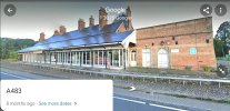
In fact at Welshpool the modern A483 runs through the old station (station building and platform still in place), while the railway was shifted eastwards via new platforms.

Following the fire in the original tubular bridge structure, the A5 was diverted to run on top of the railway Britannia bridge across the Menai Straits, with the railway, now singled, running underneath the road deck.
The A487 nearby also reuses some of the alignment of the Bangor-Caernarfon line.
A feasibility report into reopening that line says a new rail alignment would need to be built in places, as a result.

Another conversion was on the GWR Market Drayton-Wellington route where in several places the A53/A442 now uses the old rail alignment.
 
Last edited:

Ashley Hill

Established Member
Joined
8 Dec 2019
Messages
4,045
Location
The West Country
The A38 between Buckfastleigh and Ashburton. With a bit more effort I believe the line could have been saved.
 
Last edited:

NER1621

Member
Joined
14 Dec 2023
Messages
65
Location
Darlington
The A1M Darlington by-pass from Junction 56 (Barton) northwards until it crosses over the B6279 Staindrop Road is built on the trackbed of the Merrybent Railway. The quarries that the railway was built to serve can still be seen on the left of Junction 56 as you head north.

EDIT @swt_passenger just beat me to it!
 

The exile

Established Member
Joined
31 Mar 2010
Messages
4,651
Location
Somerset
Numerous urban roads, bypasses and guided busways have been constructed upon the alignment of former railway lines in the UK.

However, I am curious to learn of which A- or M- trunk roads have been laid along former railway routes?

Example:
The M90 uses some of the former Glenfarg route. It was the North British' Railway's most direct route between Edinburgh and Perth, running from Cowdenbeath to Kinross. Engineered for express speeds, the route was a double-track main line.

The A7 Edinburgh to Carlisle road follows closely to some of the former Waverley line; however, to my knowledge, none of the A7 is actually built on the old railway alignment; so it falls outside the scope of this thread.

Which others do you know of / have driven?
Edinburgh’s Western Approach Road uses the trackbed of the route in to Princes St station - I guess it’s probably an A-Road.
The bit of the ECML replaced by the Selby diversion has an A-road on part of it.
 
Joined
28 Nov 2021
Messages
234
Location
Leith
The A7 Edinburgh to Carlisle road follows closely to some of the former Waverley line; however, to my knowledge, none of the A7 is actually built on the old railway alignment; so it falls outside the scope of this thread.

Which others do you know of / have driven?

The Melrose bypass (A6091) from Tweedbank eastwards is built on the former Waverley line - which is a major reason why the reopened Borders Line stops at Tweedbank
 

Jaydubya

Member
Joined
28 Aug 2024
Messages
15
Location
London
The A414 Maldon Bypass follows the old alignment between just north of Maldon West station and Maldon East
 

Hophead

Established Member
Joined
5 Apr 2013
Messages
1,276
Much of the A267 Mayfield By-Pass in East Sussex is on a former railway alignment, which you can easily see on OS maps. This would have been the Eastbourne - Tunbridge Wells ("Cuckoo") line. Further to the south, it is the Cuckoo Trail - a popular walking route.
 

Sun Chariot

Established Member
Joined
16 Mar 2009
Messages
3,352
Location
2 miles and 50 years away from the Longmoor Milita
In fact at Welshpool the modern A483 runs through the old station (station building and platform still in place), while the railway was shifted eastwards via new platforms.
I was curious at that, so Google showed me what you meant!
(attached: former station's platform, building and canopy from Google Street View on the A483 at Welshpool)
A feast of good examples in Wales; many thanks for sharing.


Another that I've driven:
The A371 - which links Cheddar with the A38 to Bridgewater - skirts Axbridge old village and it uses the GWR's alignment. It passes next to the former station building and former goods shed (both still standing).
 

Attachments

  • Screenshot_20250310_160824_Maps.jpg
    Screenshot_20250310_160824_Maps.jpg
    607.7 KB · Views: 32
Last edited:

Top