LickeyIncliner
Member
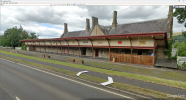
Similarly at Melrose (already mentioned) :I was curious at that, so Google showed me what you meant!
(attached: former station's platform, building and canopy from Google Street View on the A483 at Welshpool)
Similarly at Melrose (already mentioned) :I was curious at that, so Google showed me what you meant!
(attached: former station's platform, building and canopy from Google Street View on the A483 at Welshpool)
Oddly enough, it doesn't appear to be a classified road at all!Edinburgh’s Western Approach Road uses the trackbed of the route in to Princes St station - I guess it’s probably an A-Road.
I've a mental image of the two original bores being repaired and opened to road traffic - and consequential car "revving" through the tunnels...Never built, of course, but the M67 from Manchester to Sheffield would have used the same corridor as the Woodhead route, and using the tunnel(s) for some motorway traffic was considered.
Thanks for thar linkI did find an old thread that listed some more where some could be major/trunk roads
Railways that are now roads (2019)
") Before I started this thread, I had tried to find old threads on this topic but I used different keywords in my searches!
Before I started this thread, I had tried to find old threads on this topic but I used different keywords in my searches!It's unclear quite what the designers were thinking, as even the 'new' tunnel could only accommodate two lanes of traffic!I've a mental image of the two original bores being repaired and opened to road traffic - and consequential car "revving" through the tunnels...
No longer trunked, but parts of the old alignment of the A361 (now the B3227) also use the alignment of the same route.Part of the North Devon link road (A361) is built in the GWR Barnstaple - Taunton line. It even uses the pillars of Castle Hill viaduct.
Not sure if mentioned but the A4390 road is built south of Stratford Upon Avon station to the town limits. Years ago I asked the council about linking to Long Marston, a growing residential area with their decision, and the council response was they left "passive provision".
Driving on the railway line (C) John Allan
A section of the railway on the south shore of Loch Carron put to use as a temporary way for road vehicles during the long closure of the A890. The road was blocked by a landslide in December 2011 resulting in a diversion of some 140 miles.
A relief ferry was used to relieve the situation for a while until the railway was prepared to take traffic for short periods during the day.
That might also qualify as the longest/widest level crossing. I think that was how it was treated from the railway point of view?For a brief period in 2012, the A890 ran along a live railway route. The location was near the avalanche shelter south of Loch Carron, where the road and the Kyle line are squeezed together in a narrow gap between a high rock face and the shoreline.
A rock fall meant that work had to be carried out to stabilise the rock face, which meant standing heavy plant on the single-track roadway. To avoid major diversions, rubber pads similar to those used at level crossings were laid along a length of the railway track, enabling light vehicles to use it when no trains were nearby.
(Photo of the arrangement, caption below)
I believe so, I've seen photos of gates across the track at the ends of the diversion section. Of course the train service was (and still is) pretty sparse, so there were plenty of gaps.That might also qualify as the longest/widest level crossing. I think that was how it was treated from the railway point of view?
I believe that there was also a bus replacement rail service on the line at the time, as the closure cut Plockton high school off from a significant chunk of its catchment.I believe so, I've seen photos of gates across the track at the ends of the diversion section. Of course the train service was (and still is) pretty sparse, so there were plenty of gaps.