• Our new ticketing site is now live! Using either this or the original site (both powered by TrainSplit) helps support the running of the forum with every ticket purchase! Find out more and ask any questions/give us feedback in this thread!

St Johns, Woking, Footbridge Closure Dec23

Sultan

Member
Joined
6 Mar 2019
Messages
274
Hi,

I've been advised by the moderators to start a new thread and link my previous post on the SWML landslip thread (https://www.railforums.co.uk/threads/another-landslip-on-the-swml-01-12-23.258623/) to it.
1701693771567.png

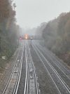
The railway goes through a very deep cutting where the landslip is, up to the road bridge St Johns Hill Road, but westwards after that, the cutting becomes less shallow (even getting to line-level on the North side) before it rises again to the footbridge. From there, within a couple of hundred yards (further west) the railway is on embankment for about 4 miles until Deepcut ranges, where again, cuttings are deep. The soil in this area is heavy clay with many mature trees, including maple. I'll comment on my known history of the road bridge and landslip in the other thread and use this thread for the footbridge. I've just been there and apart from closure, there is no change as of today (miserable damp day), but both westward lines are closed as they are working on the embankment (photos on that thread soon), with a speed restriction on both lines London-bound (usually it's 80mph).

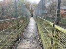
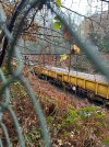
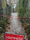
Below are some photos I've just taken but it's very difficult to get a clear shot due to the thick woodland (holly hurts!).

I've known the bridge since about 1990, when it only had 4 foot high railings - excellent for photographs - but some extra height was added in 1997(?) after the sad death of a van driver on the M3 near Bagshot where someone threw a lump of concrete off a similar bridge - the St Johns bridge was identified as a similar risk. Still, it was great for children and played a huge part in my son joining Network Rail!

It closed again in 2004(?) when the walkway itself was deemed unsafe and there was a huge uproar when there was a suggestion it would be closed permanently. It is a well-used path enabling residents of Hook Heath to reach St Johns safely, and many teenagers use it as a route to the nearby Winston Churchill Comprehensive school. It re-opened in 2005, and I even found a link here about it (https://footpath102.blogspot.com/). MPs can do good sometimes.

Judging by my photos (and I'm no engineer), the middle support has moved in the last week, which because of the clay and recent wet weather (drainage is a problem in this section), the recent cold snap may well have been the final straw. I would doubt if any work can be done for removal and replacement except from the line itself, so I'm guessing after removal, a pre-fabricated replacement will need to be planned for, along the same lines as one replaced in the Gomshall area 2-3 years ago. It's certainly going to be a (temporary) loss to the area.

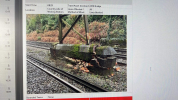
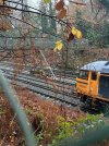
So here are today's photos. The ones of the bridge (with the moving ballast train travelling towards London) are taken from the Northern side, about 50 yards west from the bridge

Enjoy
 

Attachments

  • Footbridge (Ballast).jpg
    Footbridge (Ballast).jpg
    1.2 MB · Views: 275
  • Footbridge (with train).jpg
    Footbridge (with train).jpg
    1.1 MB · Views: 279
  • Footbridge (trainless).jpg
    Footbridge (trainless).jpg
    1.3 MB · Views: 297
  • Footbridge Closed.jpg
    Footbridge Closed.jpg
    1.3 MB · Views: 273
  • Footbridge (afar).jpg
    Footbridge (afar).jpg
    1 MB · Views: 281
  • Footbridge (Zoom).jpg
    Footbridge (Zoom).jpg
    435.1 KB · Views: 264
Last edited:
Sponsor Post - registered members do not see these adverts; click here to register, or click here to log in
R

RailUK Forums

theironroad

Established Member
Joined
21 Nov 2014
Messages
3,717
Thanks for the write up and good photos in the circumstances. Seems the middle support has deteriorated since yesterdays pic from NR.

Must admit, thought the scaffolding would be more extensive.

Only the Down Slow line is closed to normal traffic currently as it is under possession. The GBRF train with ballast wagons in your photos is on the Down Slow and will enter the possession
( edit: GBRF is on UP slow and unrelated)

The Down Fast Line is till open, as are both UP lines. The open lines all have a 20mph ESR for 5 chains on them.

the Down Fast will also close later in the week to allow more substantial work to be done at landslip site. At that point both westbound down lines will be closed but Single Line Working over the UP FAST line will be implemented to allow a limited number of trains to travel between Woking and Brookwood in the down direction under SLW rules. The UP SLOW will remain open for regular use.
 
Last edited:

Sultan

Member
Joined
6 Mar 2019
Messages
274
Thanks for the write up and good photos in the circumstances. Seems the middle support has deteriorated since yesterdays pic from NR.

Must admit, thought the scaffolding would be more extensive.

Only the Down Slow line is closed to normal traffic currently as it is under possession. The GBRF train with ballast wagons in your photos is on the Down Slow and will enter the possession.

The Down Fast Line is till open, as are both UP lines. The open lines all have a 20mph ESR for 5 chains on them.

the Down Fast will also close later in the week to allow more substantial work to be done at landslip site. At that point both westbound down lines will be closed but Single Line Working over the UP FAST line will be implemented to allow a limited number of trains to travel between Woking and Brookwood in the down direction under SLW rules. The UP SLOW will remain open for regular use.
The GBRF train is most definitely on the Up Slow line as I took the photos from the North bank, just west from the bridge. My other photos of the landslip (other thread) which is on the southern bank, are taken from the St Johns Hill road bridge.

I must admit, I didn't see any trains on the Down fast line to confirm either way - there seemed to be only 3 Network Rail people working on the bank.
 

theironroad

Established Member
Joined
21 Nov 2014
Messages
3,717
The GBRF train is most definitely on the Up Slow line as I took the photos from the North bank, just west from the bridge. My other photos of the landslip (other thread) which is on the southern bank, are taken from the St Johns Hill road bridge.

I must admit, I didn't see any trains on the Down fast line to confirm either way - there seemed to be only 3 Network Rail people working on the bank.

My bad. I've edited my post. I jumped to conclusion that was related to landslide but as I wrote it, I thought was odd as plan is to install metal sheeting into lineside later in week, then that maybe backfilled with ballast as happens elsewhere though not sure.

If you were there about 1115ish, looks like 6Y48 Eastleigh to Hoo GBRF.

Apologies for error.
 

Sultan

Member
Joined
6 Mar 2019
Messages
274
My bad. I've edited my post. I jumped to conclusion that was related to landslide but as I wrote it, I thought was odd as plan is to install metal sheeting into lineside later in week, then that maybe backfilled with ballast as happens elsewhere though not sure.

If you were there about 1115ish, looks like 6Y48 Eastleigh to Hoo GBRF.

Apologies for error.
No problem. We're all human - I was just a very wet one at the time.
 

Big Jumby 74

Established Member
Joined
12 Feb 2022
Messages
1,464
Location
UK
Hope Sultan won't mind, but here are a couple of pics I took a few years ago (on a brighter day) from the footbridge, long before the double height fencing was attached to it. In the East facing view the St. Johns Road bridge can be seen in the haze behind the 33/4 TC, beyond the signal gantry.
 

Attachments

  • BJ-St. Johns cutting looking East. June 1986.jpg
    BJ-St. Johns cutting looking East. June 1986.jpg
    503.2 KB · Views: 149
  • BJ-St. Johns cutting looking West. June 1986.jpg
    BJ-St. Johns cutting looking West. June 1986.jpg
    483.5 KB · Views: 147

Sultan

Member
Joined
6 Mar 2019
Messages
274
Excellet photos. My sons and I called the #52 train a 'Sparky' train due to the arcing (especially in Winter) of the pick-up shoes. The newer ones (Gatwick Express now?) we called 'Windy' trains (due to their speed and they blew you away). But the highlight was definitely a goods train or the utopian event when 4 trains would go under the bridge simultaneously.

It was never the same once the Desiros started to appear - quite frightening in the first year before their horns were made quieter.

I notice in your diesel-pulled photo older signal gantries.

Photo below taken well after dark on a 5+ second exposure.
 

Attachments

  • St Johns Eastwards.JPG
    St Johns Eastwards.JPG
    409.3 KB · Views: 105

DelW

Established Member
Joined
15 Jan 2015
Messages
4,695
Judging by my photos (and I'm no engineer), the middle support has moved in the last week, which because of the clay and recent wet weather (drainage is a problem in this section), the recent cold snap may well have been the final straw. I would doubt if any work can be done for removal and replacement except from the line itself, so I'm guessing after removal, a pre-fabricated replacement will need to be planned for, along the same lines as one replaced in the Gomshall area 2-3 years ago. It's certainly going to be a (temporary) loss to the area.
The raking scaffold shores shown in those informative photos definitely suggest that the cause was impact from a rail vehicle (as discussed earlier in the original thread). Earthworks-related movement would have been towards the track (i.e. parallel to the footbridge deck), which the shores now erected would be wholly ineffective at resisting.

The shores are clearly to restrain movement transverse to the deck (parallel to the tracks), some of which has already occurred as is evident from the damaged brick foundation. It's very hard to think of a mechanism that would cause that, other than impact from an out-of-gauge rail vehicle.
 

Sultan

Member
Joined
6 Mar 2019
Messages
274
The raking scaffold shores shown in those informative photos definitely suggest that the cause was impact from a rail vehicle (as discussed earlier in the original thread). Earthworks-related movement would have been towards the track (i.e. parallel to the footbridge deck), which the shores now erected would be wholly ineffective at resisting.

The shores are clearly to restrain movement transverse to the deck (parallel to the tracks), some of which has already occurred as is evident from the damaged brick foundation. It's very hard to think of a mechanism that would cause that, other than impact from an out-of-gauge rail vehicle.

To my untrained eye, this makes the most sense so far, that the central support was struck by something on the Fast-Up line as the 'kink' in the photo below (Network Rail) is taken looking Northwards (the opposite side to my photos). The closeup (Paul Clifton on Twitter/X) is showing the western aspect of the support.

Edit after WelshBlueBird's post. The ITV pictures are clearer, although I'm not so sure about it being struck now.
 

Attachments

  • GAcsn5vXwAAGG-t.jpeg
    GAcsn5vXwAAGG-t.jpeg
    251.7 KB · Views: 156
  • 1701615376558.png
    1701615376558.png
    4.1 MB · Views: 157

Big Jumby 74

Established Member
Joined
12 Feb 2022
Messages
1,464
Location
UK
The ITV pictures are clearer, although I'm not so sure about it being struck now.
It does look odd I agree. Likewise, I have no specific knowledge of such matters, but what is evident there is no apparent damage/dislodged ballast at track level in the immediate area. It's like the structure above has moved with enough force to break what may have been a weakened brick support at ground level. But again, no obvious signs of damage to the stanchion in the photo's posted thus far? Unless a raised on track crane jib has clouted the bridge walkway above?
 

HSTEd

Veteran Member
Joined
14 Jul 2011
Messages
18,526
In the post eschede environment, would we expect a replacement structure (assuming the opportunity is not taken by Network Rail to attempt to fait-accompli a closure), to be a single span to remove the pier in the middle?
 

DelW

Established Member
Joined
15 Jan 2015
Messages
4,695
For me, the key photo is the second one on the ITV page (a clearer version of the Paul Clifton one). That shows that the upper courses of the brick pier have lifted off their beds at the country end - only - of the pier. The only mechanism I can envisage that would cause that is a force applied either near the top of the steel columns, or possibly against the deck (depending on the fixity of the pier to deck connection).

That implies it being struck by something travelling in the up direction. It could only have been either low speed or a glancing blow, though, otherwise it would surely have brought the whole deck down.

In the post eschede environment, would we expect a replacement structure (assuming the opportunity is not taken by Network Rail to attempt to fait-accompli a closure), to be a single span to remove the pier in the middle?
That would possibly be the simplest, as it avoids having to rebuild the pier base at track level. I could envisage a through truss deck spanning between beefed-up bank seats.
 

Sultan

Member
Joined
6 Mar 2019
Messages
274
In the post eschede environment, would we expect a replacement structure (assuming the opportunity is not taken by Network Rail to attempt to fait-accompli a closure), to be a single span to remove the pier in the middle?
I would be surprised if a single span would work across a wide expanse without support in the middle. The embankments are mostly clay (with minimal topsoil) so would be susceptible to 'heave' unless a lot of support was introduced either end, which would be difficult to achieve without closing the railway itself - the site is pretty inaccessible to anything larger that a van. One end of the bridge is only feet from a dwelling, and the other a few yards from the Golf course car-park, which has very mature trees on it (and a dwelling yards away).

I would imagine something similar to the Shere Heath bridge (near Gomshall) would be required, and installed likewise by moving it there from the West probably via the A322 which fortunately has no low bridges between the A3 / M3.

This is what I can find on the Shere Heath Bridge, and how it was installed (likewise, no access except from the railway itself), although the North Downs railway is only 2 tracks.

https://lumiflonusa.com/case-studie...ong-lasting-high-performance-coatings-system/
 

DelW

Established Member
Joined
15 Jan 2015
Messages
4,695
I would be surprised if a single span would work across a wide expanse without support in the middle. The embankments are mostly clay (with minimal topsoil) so would be susceptible to 'heave' unless a lot of support was introduced either end, which would be difficult to achieve without closing the railway itself - the site is pretty inaccessible to anything larger that a van. One end of the bridge is only feet from a dwelling, and the other a few yards from the Golf course car-park, which has very mature trees on it (and a dwelling yards away).
As best I can tell from measuring Google's satellite view (so less than rigorous), the existing bridge is around 40 yards long (Google seems to operate in primitive units).

So even setting bankseats a bit further back, something like this could work:


Nusteel were awarded the contract to design, fabricate, paint and install this new bridge connecting Bexley and Bexleyheath. The structure is composed of a 52 metre partially Top-tied Bow Warren span

The Shere bridge seems to have used precast concrete abutments, which might work here as well. It's also possible to install in-situ concrete piles using a shell and auger rig, which can be towed by a Land Rover.

Of course there's still the task of erecting the deck. I don't know whether the bare truss would be within the lift capacity of one of the Kirov rail cranes. If not, the single span is probably ruled out.
 

Deepgreen

Established Member
Joined
12 Jun 2013
Messages
6,895
Location
Gomshall, Surrey
As best I can tell from measuring Google's satellite view (so less than rigorous), the existing bridge is around 40 yards long (Google seems to operate in primitive units).

So even setting bankseats a bit further back, something like this could work:


The Shere bridge seems to have used precast concrete abutments, which might work here as well. It's also possible to install in-situ concrete piles using a shell and auger rig, which can be towed by a Land Rover.

Of course there's still the task of erecting the deck. I don't know whether the bare truss would be within the lift capacity of one of the Kirov rail cranes. If not, the single span is probably ruled out.
Or two cranes...?
 

Meerkat

Established Member
Joined
14 Jul 2018
Messages
9,175
This footbridge was on my old school cross country running route!
Its pretty popular, though the wealthy residents and the golf club to the south will probably like it being closed - reducing the riff raff wandering through!
Would the bridge metalwork be stronger than the brickwork in the photo - ie if the embankments have moved/sunk would the metalwork deform before it pushed the bridge off the brick pier creating the break seen in the photo (to me the pier looks twisted rather than displaced along the track?) Not sure the scaffolding proves it’s been struck - looks like an A-frame that maybe the best vertical support they could make in restricted clearance??
Its just a footpath, so the replacement doesn’t need to be massive - could they use an Electrification piling rig to put two decent piles in either side of the track, so that little weight goes on the embankment, then lift in a lightweight replacement deck? The replacement could be built in or delivered to Woking yard and trundled down - its barely a mile away.
 

DelW

Established Member
Joined
15 Jan 2015
Messages
4,695
This footbridge was on my old school cross country running route!
Its pretty popular, though the wealthy residents and the golf club to the south will probably like it being closed - reducing the riff raff wandering through!
Would the bridge metalwork be stronger than the brickwork in the photo - ie if the embankments have moved/sunk would the metalwork deform before it pushed the bridge off the brick pier creating the break seen in the photo (to me the pier looks twisted rather than displaced along the track?) Not sure the scaffolding proves it’s been struck - looks like an A-frame that maybe the best vertical support they could make in restricted clearance??
Its just a footpath, so the replacement doesn’t need to be massive - could they use an Electrification piling rig to put two decent piles in either side of the track, so that little weight goes on the embankment, then lift in a lightweight replacement deck? The replacement could be built in or delivered to Woking yard and trundled down - its barely a mile away.
The scaffolding that's been installed (raking shores) is definitely to provide lateral restraint to the bridge rather than vertical support. There would be much better (and more effective) ways of providing that if it had been required.

The visible movement of the bridge is transverse to the deck (parallel to the tracks) and I can't envisage any likely form of ground movement that would cause that without other effects being evident.
 

Big Jumby 74

Established Member
Joined
12 Feb 2022
Messages
1,464
Location
UK
The visible movement of the bridge is transverse to the deck (parallel to the tracks) and I can't envisage any likely form of ground movement that would cause that without other effects being evident.
Completely agree. The weakest part of the structure (the brickwork at the lower part of the support) have given way due to something rail mounted having hit the deck above, and distorted same, as per pics. This bridge (was) nice and straight to walk across. Seems the bridge metals have stood up well to the impact, but over the years the brickwork below has weakened being subject to ground level water etc etc.
 

Deepgreen

Established Member
Joined
12 Jun 2013
Messages
6,895
Location
Gomshall, Surrey
Yes, maybe, though I think that a tandem lift in that location would need some quite tricky positioning ...
With four tracks available I would have thought two cranes could be positioned quite easily (e.g. one up slow and one down slow) to lift a span into position. Not the simplest job, of course, but there is very good rail access to the site. Or a span fabricated in two sections and bolted together on installation.

The scaffolding that's been installed (raking shores) is definitely to provide lateral restraint to the bridge rather than vertical support. There would be much better (and more effective) ways of providing that if it had been required.

The visible movement of the bridge is transverse to the deck (parallel to the tracks) and I can't envisage any likely form of ground movement that would cause that without other effects being evident.
Yes, I have to say I simply cannot see any other cause but a rail vehicle strike. I checked RTT for the 24 hours before the closure and couldn't immediately see an engineering working on the up lines, but perhaps a down lines movement connected with the bank slip further along passed and reversed? If the strike was at deck level it suggests a raised digger arm or similar. I am only speculating of course... If the ground had moved (and why would it at the base of the cutting, under the lowest point of the permanent way?) there would be track displacement but the photos show the tracks pretty much perfectly aligned with no evidence of disturbance at all.
 
Last edited:

Meerkat

Established Member
Joined
14 Jul 2018
Messages
9,175
If it had been struck hard enough to fracture two brick piers wouldn’t that flimsy bridge have some very visible deck damage, particularly if it was a narrow hit such as a digger arm?
Not a good angle on the up pillar but it looks ok, whereas the centre and down side piers are fractured, suggesting an impact would be up direction on the down lines.
edit - looking again at how the metalwork joins the piers a hit going down the down lines could do that
But my theory of an embankment movement doesn’t look great now that I have been reminded that there are three pillars, so the flimsy bridge deck dipping at one end wouldn’t do that!
 

Sultan

Member
Joined
6 Mar 2019
Messages
274
The replacement could be built in or delivered to Woking yard and trundled down - its barely a mile away.
Not sure how they would get it from Woking yard to the site. Less than a mile but 2 significant (low) bridges in the way. Probably easier via road to the A322, a mile westward where it can be craned up onto the railway.
 

Meerkat

Established Member
Joined
14 Jul 2018
Messages
9,175
Not sure how they would get it from Woking yard to the site. Less than a mile but 2 significant (low) bridges in the way. Probably easier via road to the A322, a mile westward where it can be craned up onto the railway.
A footbridge on trolleys isn’t going to be higher and wider than a train is it?
Dont know how you would crane it off the A322, no space for the crane.
 

Sultan

Member
Joined
6 Mar 2019
Messages
274
A footbridge on trolleys isn’t going to be higher and wider than a train is it?
Dont know how you would crane it off the A322, no space for the crane.
Let's leave it to the experts. They probably know best.
 

Benjwri

Established Member
Joined
16 Jan 2022
Messages
2,347
Location
Bath
Not a good angle on the up pillar but it looks ok, whereas the centre and down side piers are fractured, suggesting an impact would be up direction on the down lines.
Impact in up direction on the down lines is not out of the question, as the landslide is on the down side, and this is the side that has been under constant possession, so an engineering train arriving from the west would likely be travelling up on the down lines to reach the track.
 

DelW

Established Member
Joined
15 Jan 2015
Messages
4,695
With four tracks available I would have thought two cranes could be positioned quite easily (e.g. one up slow and one down slow) to lift a span into position. Not the simplest job, of course, but there is very good rail access to the site. Or a span fabricated in two sections and bolted together on installation.
The problem is that if the deck comes in by rail, it has to be turned through 90° - and it's long. Not too hard to tandem lift with two crawlers, since they can move with a load on the hook, but I doubt if the Kirovs can.
Let's leave it to the experts. They probably know best.
No-one is going to use this discussion as the basis of a method statement ;) Meanwhile I quite enjoy speculating - I used to do this sort of stuff for a living, and it's so much easier as a spectator!
 

Sultan

Member
Joined
6 Mar 2019
Messages
274
The problem is that if the deck comes in by rail, it has to be turned through 90° - and it's long. Not too hard to tandem lift with two crawlers, since they can move with a load on the hook, but I doubt if the Kirovs can.

No-one is going to use this discussion as the basis of a method statement ;) Meanwhile I quite enjoy speculating - I used to do this sort of stuff for a living, and it's so much easier as a spectator!
When you say 'crawlers', do you mean vehicular from the side, and not from the railway itself?

The Northern side, which is feet away from a dwelling, also descends sharply within 100 yards (red ^^), through a wood, across a brook (blue) and onto St Johns lye, with a number of mature horse-chestnuts over-hanging. And that's before considering how to get to the village by road in the first place. From the North, there would be a 90-degreee turn across a (weight restricted) bridge over the canal. From the south (of the village, not the railway), the only route is St Johns Road, which also has significant width restrictions. It would be challenging to deliver a 40-yard bridge from the North.

The Southern side is more level, and within 20 yards is the Golf club car park. However, it is not tarmac - just a forest-car park, with very mature oak trees and a significant metal fence. But access to here would be the bigger problem, as there are a couple of tight 90-degree corners along a residential road to get to the southern side of the road bridge at St Johns Hill Road (where the separate land slip is).

So, in speculation, it'll be either bringing in a replacement span by rail, or building a bridge from parts brought in. By rail, 'DeepGreen' has already mentioned the footbridge nearer Woking (off this map) at Wych Hill and the St Johns Hill Road bridge. The only access I can see without having to either negotiate a low(ish) bridge or significant height differentials between line-height and embankment (be-it 30 feet above or below) is at the A322 (left on this map). I've added some ^ or v beside the line to show height (showing direction of downwards).

I remember in the early 2000s(?) Network Rail built a road across the village green with hardcore (dotted blue) so that they could bring in all the materials 400 yards to the railway (Northern side) to build a sub-station about 200 yards west of the footbridge to cope with the increased demands of Desiro trains. You wouldn't know they had been there now, as everything was removed afterwards (including the road) and the substation is hidden behind trees. Again, I apologise for the crudity of the map!

1701787451146.png
 
Last edited:

Big Jumby 74

Established Member
Joined
12 Feb 2022
Messages
1,464
Location
UK
If it had been struck hard enough to fracture two brick piers wouldn’t that flimsy bridge have some very visible deck damage,
Just looking at the images with the 56 on the USL again, that brick foundation pier on the DSL (far) side (stanchion covered in ivy), although the brickwork is broken in a similar manner to that of the obviously recently damaged centre pier (in the 10 foot), the damage to the DSL side pier does not look recent, no signs of fresh brick rubble either in the crack or lying around. But obviously a point of weakness none the less.
 

Top