• Our booking engine at tickets.railforums.co.uk (powered by TrainSplit) helps support the running of the forum with every ticket purchase! Find out more and ask any questions/give us feedback in this thread!

Strange Feature between Dorchester West and Maiden Newton

Status
Not open for further replies.

DynamicSpirit

Established Member
Joined
12 Apr 2012
Messages
8,226
Location
SE London
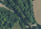
Google maps shows this rather interesting track arrangement between Dorchester West and Maiden Newton: (Link)

Is there something unusual going on under the trees, or is this simply likely to be a (rather exceptional) artifact of Google maps?
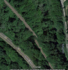
1690559528992.png
 
Sponsor Post - registered members do not see these adverts; click here to register, or click here to log in
R

RailUK Forums

Wilts Wanderer

Established Member
Joined
21 Nov 2016
Messages
2,505
Strongly suspect that is a distortion in the photographs used on Gmaps. There isn’t anything odd about the single line in that area.
 

DelW

Established Member
Joined
15 Jan 2015
Messages
3,902
Such oddities can often be seen where the software has stitched adjacent photos together.
 

Mcr Warrior

Veteran Member
Joined
8 Jan 2009
Messages
11,943
As the comedian Eric Morecambe used to say...

"You can't see the join!"

Except, in this particular instance, you very definitely can!
 

DynamicSpirit

Established Member
Joined
12 Apr 2012
Messages
8,226
Location
SE London
As the comedian Eric Morecambe used to say...

"You can't see the join!"

Except, in this particular instance, you very definitely can!

Haha! Curious though how the join has affected the image of the railway so dramatically but the nearby roads line up fine. I wonder if they are using some algorithms or AI that are geared to roads but not so good on railways.
 

snowball

Established Member
Joined
4 Mar 2013
Messages
7,761
Location
Leeds
Some years ago there was a place on the M4 in South Wales where Google made it seem that a stretch of the motorway had sunk by several feet, and vehicles approaching from either side would fall off a small cliff.
 

Mcr Warrior

Veteran Member
Joined
8 Jan 2009
Messages
11,943
Maybe the "join" is needed so that the mapping software doesn't reckon that there's two "dead end" sections of road when providing journey itineraries, as is actually now the case on the one time section of the A625 below Mam Tor, just to the West of Castleton (Derbyshire)?!
 

The exile

Established Member
Joined
31 Mar 2010
Messages
2,762
Location
Somerset
Some years ago there was a place on the M4 in South Wales where Google made it seem that a stretch of the motorway had sunk by several feet, and vehicles approaching from either side would fall off a small cliff.
Just over the Severn Bridge there’s a few places where it feels as if it does!
 

DynamicSpirit

Established Member
Joined
12 Apr 2012
Messages
8,226
Location
SE London
Maybe the "join" is needed so that the mapping software doesn't reckon that there's two "dead end" sections of road when providing journey itineraries, as is actually now the case on the one time section of the A625 below Mam Tor, just to the West of Castleton (Derbyshire)?!

Details?? I just looked around Castleton on Google maps but couldn't see any dead ends.
 

Mcr Warrior

Veteran Member
Joined
8 Jan 2009
Messages
11,943
Details?? I just looked around Castleton on Google maps but couldn't see any dead ends.
Geograph is your friend...

See also the accompanying (scrollable) OS map extract.


Extract...
The road was patched and limited to a single lane over the affected area and kept open until 1979.

In 1979 the road was closed to through traffic.
 

Tomnick

Established Member
Joined
10 Jun 2005
Messages
5,840
Details?? I just looked around Castleton on Google maps but couldn't see any dead ends.
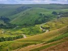
20230724_170756.jpg
A photo that I took earlier this week to demonstrate!

(Image is a view looking down from atop a hill – the ridge running off Mam Tor – looking down at a road winding its way up the valley below, visibly badly distorted and broken as it intersects an area where there are clear signs of slow, long-term ground movement)
 

Flange Squeal

Established Member
Joined
17 Jul 2012
Messages
1,270
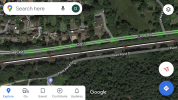
The way images join does create some interesting features, for example just east of Fleet station you find an 18 car Class 444 formation made up of two traditional five cars units sandwiched either side of a unique eight car!

IMG_2604.png
 

DelW

Established Member
Joined
15 Jan 2015
Messages
3,902
View attachment 139937
A photo that I took earlier this week to demonstrate!

(Image is a view looking down from atop a hill – the ridge running off Mam Tor – looking down at a road winding its way up the valley below, visibly badly distorted and broken as it intersects an area where there are clear signs of slow, long-term ground movement)
That photo certainly demonstrates why the engineers gave up! It's hard to recognise that that was once an A-road.
 

DynamicSpirit

Established Member
Joined
12 Apr 2012
Messages
8,226
Location
SE London
The way images join does create some interesting features, for example just east of Fleet station you find an 18 car Class 444 formation made up of two traditional five cars units sandwiched either side of a unique eight car!

View attachment 139938

Haha! That's a good one. Not quite the same thing though - as I imagine that one is easy to explain as one image being taken a few seconds later than the other one and the train moved during that time - so not actually any mismatch in the geographical features.

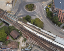
One that I suspect might be similar in origin - although a bit harder to figure out exactly how it came about - is the two ghost trains fading into nothingness at Dartford station:

1690576453328.png
 

snowball

Established Member
Joined
4 Mar 2013
Messages
7,761
Location
Leeds
Details?? I just looked around Castleton on Google maps but couldn't see any dead ends.

The A6187 turns into two minor roads west of Castleton. it's extremely clear on OS mapping.

The road that collapsed was a fairly important one, the A625, a possible Sheffield-Manchester route, that has never been replaced.

Today the A625 just goes from Sheffield to Calver. Before the events of the 1970s described above it followed what is now the A6187 through Hathersage, parallel to the Hope Valley line, through Hope and Castleton, and continued via Mam Tor, along what is now a minor road below Rushup Edge to Chapel-en-le-Frith, then via the present B5470 to Horwich End (just south of Whaley Bridge) on the present A5004 (then A6).
 
Last edited:
Status
Not open for further replies.

Top