-
Our booking engine at tickets.railforums.co.uk (powered by TrainSplit) helps support the running of the forum with every ticket purchase! Find out more and ask any questions/give us feedback in this thread!
You are using an out of date browser. It may not display this or other websites correctly.
You should upgrade or use an alternative browser.
You should upgrade or use an alternative browser.
Trivia: Abandoned railway lines that have been turned into cycle/footpaths
- Thread starter Acc3lerat1on
- Start date
- Status
- Not open for further replies.
Sponsor Post - registered members do not see these adverts; click here to register, or click here to log in
R
RailUK Forums
steamybrian
Established Member
Thanks - I have amended WikipediaWhere to start.
Lancaster to Morecambe.
Preston, well from West View Leisure centre up towards Grimsargh on the old Longridge line mostly footpath though about 100 metres plus is cycle path for the Guild Wheel cycle route.
Preston towards Bamber Bridge on the old East Lancs line out of Preston including part of the triangle towards Southport as that path now drops down to Leyland road in Penwortham.
Hawarden Bridge back towards Chester on the old avoiding line from Shotton steelworks to Mickle Mickle Trafford line.
The Granite way footpath cycle route from okehampton to Lydford over Meldon viaduct.
This forms part of the Devon coast to coast cycle route from ilfracombe to plymouth which also includes the previously mentioned tarka trail route barnstaple to meeth and the ilfracombe to barnstaple cycle and footpath routes.
All three cycle routes are great to explore.
The innocent railway cycle footpath at the back of Arthur's seat in Edinburgh.
Elgin towards lossiemouth
Forgot to mention the
Padiham greenway on the old line from rose grove towards Blackburn.
Certainly cycle footpath through padiham towards Great Harwood.
M&SWJ Railway in Swindon Wiltshire is a good line to walk.
It starts at Rushey Platt to Swindon Town.
I have walked it several times.
If you know where to look you can find the remains of Rushey platt Upper station.
It can get a bit of water in places if its wet.
Several good views from the cycleway. also a good view of the old canal.
Thanks- I have added this to Wikipedia- what is the mileage ?
Honeybourne Link in Cheltenham
Thanks- I have added this to Wikipedia
The former LMS line from Swansea Victoria along the bay and up to Gowerton has been a cycle path for many years. Very popular on a nice day @
Thanks- now added to Wikipedia.
I will added other contributions when I have spare time.
Millisle
Member
Two that I do not think have been mentioned are:
The Speyside Way
It runs from Aviemore to Buckie (on the former GNOSR coast road from Elgin to Aberdeen, closed 1968). It uses the solum of the Boat of Garten - Elgin line between Ballindalloch and Craigellachie, closed passengers 1965, goods 1968, and in part I think, between Grantown on Spey and Nethy Bridge. There used to be a branch walk from Craigellachie to Dufftown (GNOSR line to Keith Junction), but that has been discontinued owing to a landslip.
The Dava Way
This is from Grantown on Spey to Forres using the original Highland Railway road to Inverness (before the Slochd route was built), closed 1965
ashkeba
Established Member
- Joined
- 13 May 2019
- Messages
- 2,171
1 mile of the former Waveney Valley Line east of Bungay has become part of cycle route 30. Macadam surface.
4.5 miles of the Midland & Gt Northern from Bengate to Stalham and 4.5 miles from North Walsham to Aylsham are parts of the Weaver's Way local cycle route.
3 miles of the Stour Valley Railway through Haverhill and 3 miles north from the current open section's terminal at Sudbury are cycle routes. Part of the Sudbury one is route 13.
About eight miles of the trackbed between Yelverton and Princetown is open for walkers and cyclists on Dartmoor, complete with a rebuilt bridge over the B3212, though it's a pretty rough track and not up to the standard of many formal cycle paths.
Llandudno
Established Member
- Joined
- 25 Dec 2014
- Messages
- 2,221
Walked the Middlewood Way (Marple - Macclesfield) yesterday in fabulous weather.
Great day out circa 11 miles, mostly flat, obviously, and well maintained path segregated in many places between cyclists, horse riders and pedestrians. Some decent pubs en-route, most open all day, midweek or just 100-200 yards from the path.
Highly recommend, suggest using a TfGM Wayfarer (Adults £14.40) as valid from both Marple Stations, Middlewood and Macclesfield.
DerekC
Established Member
WRT linking the Meon Valley Trail into Fareham. Here's a Google Earth view of the bridge over the Meon with clear space for a footpath on the North side. It's only 150 yards west to Knowle Junction and another 150 yards east to the little industrial estate next to Mayles Lane. I will ping an email to Hampshire CC. Must be a grant going somewhere!!

steamybrian
Established Member
1 mile of the former Waveney Valley Line east of Bungay has become part of cycle route 30. Macadam surface.
4.5 miles of the Midland & Gt Northern from Bengate to Stalham and 4.5 miles from North Walsham to Aylsham are parts of the Weaver's Way local cycle route.
3 miles of the Stour Valley Railway through Haverhill and 3 miles north from the current open section's terminal at Sudbury are cycle routes. Part of the Sudbury one is route 13.
Thanks- I have added these to Wikipedia. Have amended Haverhill to 1.5 miles
About eight miles of the trackbed between Yelverton and Princetown is open for walkers and cyclists on Dartmoor, complete with a rebuilt bridge over the B3212, though it's a pretty rough track and not up to the standard of many formal cycle paths.
Thanks- I have added this to Wikipedia as Dousland to Princetown Railway Track
ashkeba
Established Member
- Joined
- 13 May 2019
- Messages
- 2,171
Is that because it's interrupted by Tesco's car park at that point?Thanks- I have added these to Wikipedia. Have amended Haverhill to 1.5 miles
DerekC
Established Member
About a mile of the Longmoor Military Railway, from Liss station as far as the road crossing north of Liss Forest, is a very attractive walk and cycle path with interpretation boards and a nature trail running off it. The LMR platform at Liss, complete with canopy, still stands beside the line and there are quite a few "WD" marked concrete sleepers buried in the undergrowth beside the trail over the first couple of hundred yards where there was a siding. The bridges over the Rother and Blackwater have been rebuilt for pedestrian/cycle use.
About another two miles running through the Longmoor military area is accessible at certain times, I think, but I haven't managed to get there when the army isn't using it as yet! Maybe someone else can help with this bit.
About another two miles running through the Longmoor military area is accessible at certain times, I think, but I haven't managed to get there when the army isn't using it as yet! Maybe someone else can help with this bit.
steamybrian
Established Member
[
Thanks- I have added Liss to Liss Forest Road to Wikipedia list.
I have not added Longmoor Military area unless someone can confirm it is accessible to the public.
About a mile of the Longmoor Military Railway, from Liss station as far as the road crossing north of Liss Forest, is a very attractive walk and cycle path with interpretation boards and a nature trail running off it. The LMR platform at Liss, complete with canopy, still stands beside the line and there are quite a few "WD" marked concrete sleepers buried in the undergrowth beside the trail over the first couple of hundred yards where there was a siding. The bridges over the Rother and Blackwater have been rebuilt for pedestrian/cycle use.
About another two miles running through the Longmoor military area is accessible at certain times, I think, but I haven't managed to get there when the army isn't using it as yet! Maybe someone else can help with this bit.
Thanks- I have added Liss to Liss Forest Road to Wikipedia list.
I have not added Longmoor Military area unless someone can confirm it is accessible to the public.
bramling
Veteran Member
Another obscure one:
About half a mile of the former Newton Noyes branch in Milford Haven is a surfaced footpath / cycle path.
About half a mile of the former Newton Noyes branch in Milford Haven is a surfaced footpath / cycle path.
steamybrian
Established Member
Thanks - now added to Wikipedia as " Milford Haven"Another obscure one:
About half a mile of the former Newton Noyes branch in Milford Haven is a surfaced footpath / cycle path.
The southern half of the Stokes Bay line in Gosport is now a footpath and cycle path.
Thanks- now added to Wikipedia.
I have also added Gosport to Brockhurst (at or near former Fort Brockhurst station) which I estimate is approx 2 miles (?)
The footpath from South Bermondsey station to the away end at Millwall follows, for the most part, one of the lines that used to go into Bricklayers Arms.
I estimate a very short section of approx 100 yards.
For the same reason I have not added Croydon Central branch (part of Queens Gardens in Croydon) as only a short section available.
Last edited:
I didn't put this up to get it added but it's an edited version of a post I put on another thread:I estimate a very short section of approx 100 yards.
For the same reason I have not added Croydon Central branch (part of Queens Gardens in Croydon) as only a short section available.
The footpath from South Bermondsey station to the away end at Millwall follows, for the most part, one of the lines that used to go into Bricklayers Arms. The path continues behind one of the stands (though it is locked when a game is on) and between the path and the stand there are remnants of the railway tracks.
The path following the old railway is considerably longer than 100 yards as it continues behind the stand. It also continues in the opposite direction from South Bermondsey station as the NLS map shows
steamybrian
Established Member
I didn't put this up to get it added but it's an edited version of a post I put on another thread:
The path following the old railway is considerably longer than 100 yards as it continues behind the stand. It also continues in the opposite direction from South Bermondsey station as the NLS map shows
Having passed Millwall Football Ground many times by train I assumed the path only led the short distance to South Bermondsey Station.
I have now had chance to examine the map more carefully and I can now understand the footpath system. Accordingly I agree it follows the alignment of the former Bricklayers Arms branch including a new bridge over Rotherhithe New Road. I have therefore added it to the Wikipedia list under Bermondsey. I estimate the distance is about 0.5 miles. Please comment further if required. Thanks for the gen.
The line to Thorp Arch has been extended to Newton Kyme across the recently renovated bridge over the River Wharfe. The funding for this was provided by the developers of a large housing state at Newton Kyme. It makes a very useful off-road route to the Thorp Arch trading estate and Wetherby.There are loads! Some Sustrans-type, and some which are just muddy footpaths.
...
Part of two of the lines out of Wetherby - to Spofforth going north, and Thorpe Arch going south.
The line to Thorp Arch has been extended to Newton Kyme across the recently renovated bridge over the River Wharfe. The funding for this was provided by the developers of a large housing state at Newton Kyme. It makes a very useful off-road route to the Thorp Arch trading estate and Wetherby.
Cheers - Didn't know that! Must pay a visit. That bridge was in quite a state a few years ago so there must have benn a fair bit of money available.
That's great.Having passed Millwall Football Ground many times by train I assumed the path only led the short distance to South Bermondsey Station.
I have now had chance to examine the map more carefully and I can now understand the footpath system. Accordingly I agree it follows the alignment of the former Bricklayers Arms branch including a new bridge over Rotherhithe New Road. I have therefore added it to the Wikipedia list under Bermondsey. I estimate the distance is about 0.5 miles. Please comment further if required. Thanks for the gen.
Grecian 1998
Member
Parts of the Maiden Newton to Bridport and West Bay line. I think the plan is to reopen the full length as a cycle path at some point, but progress is slow and there may be a few problems in the Bridport area.
The Two Tunnels Greenway meets the Colliers Way at Midford, so the whole of the S&D route from Bath Green Park to the outskirts of Wellow is accessible. There's another section of the old S&D route in North Dorset from Sturminster Newton to Spetisbury which forms part of the North Dorset Trailway.
The signs on the Rodwell Trail state it opened in 2000. Presumably it was accessible some years before that though.
The Two Tunnels Greenway meets the Colliers Way at Midford, so the whole of the S&D route from Bath Green Park to the outskirts of Wellow is accessible. There's another section of the old S&D route in North Dorset from Sturminster Newton to Spetisbury which forms part of the North Dorset Trailway.
The former Weymouth and Portland Railway is part of the Rodwell Trail. Wikipedia claims it opened in 2000, but I remember walking it in the early 1980s
The signs on the Rodwell Trail state it opened in 2000. Presumably it was accessible some years before that though.
steamybrian
Established Member
Parts of the Maiden Newton to Bridport and West Bay line. I think the plan is to reopen the full length as a cycle path at some point, but progress is slow and there may be a few problems in the Bridport area.
The Two Tunnels Greenway meets the Colliers Way at Midford, so the whole of the S&D route from Bath Green Park to the outskirts of Wellow is accessible. There's another section of the old S&D route in North Dorset from Sturminster Newton to Spetisbury which forms part of the North Dorset Trailway.
The signs on the Rodwell Trail state it opened in 2000. Presumably it was accessible some years before that though.
Thanks- I will add Bridport to West Bay to the Wikipedia list as I was in that area last year and remember seeing the path.
The Two Tunnels Greenway is already on Wikipedia list and have added NCR4 to Wellow.
Can someone with knowledge of Cumbria tell me if the route of the former Brampton Railway of one and half miles between Brampton (Junction) station and Brampton Town is accessible by cycle although I am aware it is a public footpath...?
Part of the Derwent Valley Light rail (York), From the Nestle factory to Osbaldwick.
Thanks- now added to Wikipedia as York to Osbaldwick- what is the mileage?
Cheers - Didn't know that! Must pay a visit. That bridge was in quite a state a few years ago so there must have benn a fair bit of money available.
Thanks- Have added Wetherby to Thorp Arch and Spofforth to Wikipedia list
Last edited:
tavistock
Member
The Wirral Way.. West Kirby to Hooton via Neston.Abandoned railway lines that were converted to a cycle/footpath. Of the top of my head, I can remember the Bristol - Bath cycle path.
DaveF63
Member
Two paths I'm familiar with from my Uni days in Bath are:
-The Two tunnels greenway, which incorporates the old Somerset & Dorset railway from Bath through to Midford and a bit beyond, which includes Combe Down tunnel and music occasionally playing inside.
This route continues though to Wellow, & then on road, until you approach Radstock where it rejoins the track line.
There's also Colliers Way along the old GWR Radstock branch, from Radstock to near Frome, where they're trying to finalize the last stretch into the town.
DaveF63
Member
The Two Tunnels Greenway is already on Wikipedia list and have added NCR4 to Wellow.
Two Tunnels Greenway is NCN 244
Colliers Way is NCN 24 (NCN 4 is from Bath to Bristol)
I've update wikipedia to suit.
steamybrian
Established Member
Two Tunnels Greenway is NCN 244
Colliers Way is NCN 24 (NCN 4 is from Bath to Bristol)
I've update wikipedia to suit.
Noted with thanks
Have also added Radstock to Frome
charley_17/7
Member
Dunno if the 'Newport Nobby' branch, now part of the Milton Keynes Redway network has been mentioned?
Also the Three Bridges to East Grinstead, now known as 'The Worth Way'?
Also the Three Bridges to East Grinstead, now known as 'The Worth Way'?
Halifaxlad
Established Member
The Great Northern Railway from Queensbury to Thornton and a separate shorter section from Hewden Viaduct to Cullingworth.
Referred to as the 'Great Northern Railway Trail' they're long term ambitions to connect these two paths up that go through Denholme.
This is also adjacent to the long running Queensbury Tunnel campaign, who want to make a cycle route from Halifax to Keighley & Bradford via the tunnel!
 www.queensburytunnel.org.uk
Referred to as the 'Great Northern Railway Trail' they're long term ambitions to connect these two paths up that go through Denholme.
This is also adjacent to the long running Queensbury Tunnel campaign, who want to make a cycle route from Halifax to Keighley & Bradford via the tunnel!
Queensbury Tunnel
steamybrian
Established Member
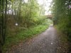
Continues east of East Grinstead to Groombridge as the Forest Way. Here is a photo taken on the Forest Way (near Withyham) a few days ago. Also of note that the trackbed for several miles was built for double line but only a single line was ever laid.Also the Three Bridges to East Grinstead, now known as 'The Worth Way'?
Attachments
Eyersey468
Established Member
- Joined
- 14 Sep 2018
- Messages
- 2,175
The old line between Market Weighton and Beverley is also a public footpath now as is part of the old line towards Driffield and the one to Selby
Edited to add there is also the old line at Bakewell which is also a footpath and cycle route now
Edited to add there is also the old line at Bakewell which is also a footpath and cycle route now
- Status
- Not open for further replies.