• Our new ticketing site is now live! Using either this or the original site (both powered by TrainSplit) helps support the running of the forum with every ticket purchase! Find out more and ask any questions/give us feedback in this thread!

Two additional tracks to be built into Leeds station from the West?

modernrail

Established Member
Joined
26 Jul 2015
Messages
1,259
I just think it all gets a bit odd at Leeds if you have another 2 tracks on the western approach but nothing is done on the Eastern side.

I understand that a 2 track railway notionally can pump a lot of trains through it, but that throws up 2 questions for me. Why do you need 2 more at the western end when you don’t at the eastern, and why (anecdotally from waiting for trains) do delays seem to originate from congestion or failures from the eastern end if a 2 track railway should be able to handle the load.
 
Sponsor Post - registered members do not see these adverts; click here to register, or click here to log in
R

RailUK Forums

Old Rick

New Member
Joined
28 Jan 2025
Messages
2
Location
God's own county
Why do you need 2 more at the western end when you don’t at the eastern,
No-one is saying that we don't. It is just a matter of what is reasonably possible.. The 1st diverging route going east is after 4.5 miles at Cross Gates (now extinct route to Tadcaster & Wetherby) after which it is another 6 or so miles to Micklefield. The other way, I count 6 routes diverging with 1 mile of the platform end.

One look at the topography of Leeds explains why for a long time, the only route in was from the west. It is essentially 2 ridges running NW-SE with the river Aire in the middle, with a wider basin where the city-centre is. Hudson's Y & NMR built their line off the London line at Castleford, and via Methley Junction followed the Aire to the present station (well, nearly). The Midland then reversed and went north along the Aire valley bottom, while the L&Y steadily climbed the south side of the valley to Bradford, and the Leeds Northern the north side, both originating from Central station. The GN had to avoid Beeston and Middleton hill south of the city, and so swung west into a north-going valley, dropping down the eastern flank; the other side of the same valley is used by the transpennine route bursting out of Morley tunnel.

It was the NER that finally bit the bullet to find an eastern approach. Despite avoiding the worst of Seacroft hill, they still did some serious earthworks round Cross Gates, over Wyke Beck and through Richmond Hill, and constructed Marsh Lane viaduct and embankment right through St Peter's burial ground to finally reach the station, which I believe they extended southwards. While there may be scope for improvement further out, the immediate eastern exit of the station would be seriously complex/expensive

The closure of Central in 1967 resulted in its approaches from the south being diverted into the Holbeck and Wortley junctions complex. Presumably, the closure of Harrogate to Northallerton in the same year meant that trains like the Queen of Scots pullman and the North Briton either ceased, or had to go via York.
 

Grimsby town

Member
Joined
4 Apr 2011
Messages
644
I understand that a 2 track railway notionally can pump a lot of trains through it, but that throws up 2 questions for me. Why do you need 2 more at the western end when you don’t at the eastern, and why (anecdotally from waiting for trains) do delays seem to originate from congestion or failures from the eastern end if a 2 track railway should be able to handle the load.
Because the western end has a lot more routes diverging within a short distance of Leeds Station. There's essentially 12 tracks that funnel into 6 tracks limiting the number of trains that can operate on each of those 6 double track routes. A relatively short upgrade can reduce iteraction between these line.

The route to east is two tracks for over 10 miles before dividing, so the number of services is limited by fast services catching slow services unless you expensively 4 track most or all of that route.

There's also the question of demand. Population density to the east of Leeds is far lower than to the west of Leeds as most of the West Yorkshire urban area is west of Leeds City centre. South Yorkshire and Greater Manchester are also close by. Additionally, the lines to the west serve far more and larger cities. The aforementioned Sheffield and Manchester, London, Birmingham, Liverpool, Nottingham, Bradford, Bristol etc. This compares to Newcastle/Sunderland, the Central belt, Middlesbrough and Hull to the east.

Theoretically it should be possible to operate the number of trains needed (~12 per hour) that way without 4 tracking the Leeds throat. At most you'd be looking at
  • 4 northern stopping semi/fast services
  • 2 fast services to Hull
  • 3 fast services to Newcastle
  • 1 fast to Middlesbrough
  • 1 to Scarborough
  • Perhaps 1 fast to London
That seems a good balance of providing good long distance connectivity and providing stations like Cross Gates, Thorpe Park and Garforth with at least 4 trains per hour.
 

30907

Veteran Member
Joined
30 Sep 2012
Messages
20,570
Location
Airedale
Theoretically it should be possible to operate the number of trains needed (~12 per hour) that way without 4 tracking the Leeds throat. At most you'd be looking at
  • 4 northern stopping semi/fast services
  • 2 fast services to Hull
  • 3 fast services to Newcastle
  • 1 fast to Middlesbrough
  • 1 to Scarborough
  • Perhaps 1 fast to London
That seems a good balance of providing good long distance connectivity and providing stations like Cross Gates, Thorpe Park and Garforth with at least 4 trains per hou
You need to add the ECS to and from Neville Hill, of course. The greater problem is the stopping services, for which you need a stretch of quadruple track, but only East of the depot.

Incidentally, 3tph Leeds to Newcastle looks generous on paper (and causes problems North of York, as the ECML timetablers have found), but is difficult to reduce. But that's a different topic.
 

Meerkat

Established Member
Joined
14 Jul 2018
Messages
9,208
While there may be scope for improvement further out, the immediate eastern exit of the station would be seriously complex/expensive
Expensive, but seriously expensive??
Apart from part of one inconsequential modern office building the route the south side of the viaduct looks clear - rather as though deliberately so (or the railway bought the land for quadruple??).
The only major issue would be the bridge that is being replaced over Marsh Lane, which would need to be replaced again as the added tracks would need to switch from south to north side of the current line.
 

Grimsby town

Member
Joined
4 Apr 2011
Messages
644
You need to add the ECS to and from Neville Hill, of course. The greater problem is the stopping services, for which you need a stretch of quadruple track, but only East of the depot.

Incidentally, 3tph Leeds to Newcastle looks generous on paper (and causes problems North of York, as the ECML timetablers have found), but is difficult to reduce. But that's a different topic.
Agreed if quadruple track is needed then its between Cross Gates and Garforth to allow stopping trains to be overtaken.

The 12tph was more of desirable but realistic maximum. As you point out York and beyond is a significant capacity to constraint for services east of Leeds, further limiting the impact of quadrupling the throat.
 

Meerkat

Established Member
Joined
14 Jul 2018
Messages
9,208
Would quadrupling the eastern approach to the station enable a better, faster, more flexible throat junction, possibly with longer usable platform length (from signals pushed out) and faster approach speeds from the west (due to better overlaps)??,
 

Halish Railway

Established Member
Joined
26 Apr 2017
Messages
2,032
Location
West Yorkshire / Birmingham
Would quadrupling the eastern approach to the station enable a better, faster, more flexible throat junction, possibly with longer usable platform length (from signals pushed out) and faster approach speeds from the west (due to better overlaps)??,
Four tracking still doesn’t solve the problem of the number of conflicting movements. I’d have thought that the linespeeds on the western and eastern throats are restricted by track geometry, although 25mph seems reasonable enough, especially if trains are approaching restrictive signal aspects. I do believe that the linespeed on the viaduct to the east of the station will be raised up to 55mph immediately after the station throat, which will go some way to tackling low linespeeds.
 

modernrail

Established Member
Joined
26 Jul 2015
Messages
1,259
Do we know what the extra 2 lines at the western side achieve in terms of extra paths etc?

I would love to know how many minutes of delay happens due to problems on the western approaches compared to the eastern. I have spent many hours of my life waiting for westbound trains at Leeds and the screens saying, delayed, wait for further info and then the delay just creeps up and up. I have always assumed, maybe incorrectly, that the limited number of tracks and subsequent lack of ways to get around a problem are a significant factor.

Also, if the western end does get two tracks and perhaps more bay platforms is there an argument for reconfiguring some of the middle station? It has always seemed to me it would be good to at least make the 2 bay platforms (13 and 14) into a through platform. That would be a pretty low cost bit of extra functionality? A much bigger change could see the three tracks between 11 and 12 reduced to 2, and creation of a through line and platform face adjacent to the track now serving 13 and 14. That would be 2 new through platforms in total (although 1 of them would be a joined up current 13 and 14) .
 

Bald Rick

Veteran Member
Joined
28 Sep 2010
Messages
32,057
Would quadrupling the eastern approach to the station enable a better, faster, more flexible throat junction, possibly with longer usable platform length (from signals pushed out) and faster approach speeds from the west (due to better overlaps)??,

The eastern approach is super flexible now. And you wouldnt get any more speed out of the approach with 4 tracks due to the signalling and overlaps heading west.

As others have said, you don’t need more tracks at the eastern approaches. Loops further out will help.
 

Ken H

Established Member
Joined
11 Nov 2018
Messages
6,592
Location
N Yorks
But there's not exactly alot of capacity Leeds-Harrogate
Bung in more signals then...

There is another way to york, vis Woodlesford, Castleford and Church Fenton. A scheme to wire that route and Cas - Knottingley could work.
 
Last edited:

Ben427

Member
Joined
28 Sep 2023
Messages
64
Location
Leeds
Expensive, but seriously expensive??
Apart from part of one inconsequential modern office building the route the south side of the viaduct looks clear - rather as though deliberately so (or the railway bought the land for quadruple??).
The only major issue would be the bridge that is being replaced over Marsh Lane, which would need to be replaced again as the added tracks would need to switch from south to north side of the current line.
I'm sorry to sound rude but have you looked at the map?

To four track the railway east of Leeds there's absolutely tons of buildings that would need to be purchased and demolished - everything east of Lower Briggate.

The area includes a graveyard and a substantial amount of land take outside of the rail boundary, and several major bridges that cross major roads in and out of Leeds. The cost (never mind disruption and cost to the city) would be high indeed.

Bung in more signals then...

There is another way to york, vis Woodlesford, Castleford and Church Fenton. A scheme to wire that route and Cas - Knottingley could work.
Going via Cas means more traffic through the western end which is busy as it is - as much as I'd love that part of the railway to be electrified (especially tying in Leeds-Sheffield via Normanton a la HS2 alternatives) the BCR would be abysmal.

The new lines that are being discussed sound very much what was proposed in Network Rail's Leeds Area Strategic Study here

"New X and Y lines and revised Armley Junction layout would allow segregation of Harrogate and Shipley line services on the approach to Leeds"

I imagine it's with an eye to future capacity requirements from TRU and (if it ever happens) NPR - and would allow additional platforms, although I think one or two extra platforms rather than the sometimes mooted four is more likely, just because of space and impact on car parking and other facilities there
 
Last edited:

deltic08

On Moderation
Joined
26 Aug 2013
Messages
2,784
Location
North
Trains from Leeds to the North East (Darlington, Durham, Newcastle) went from Leeds Central and went via Horsforth, Harrogate, Ripon and joined the Current East Coast line well north of York So if Harrogate - Northallerton were extant today it would relieve Leeds - York via Church Fenton.
Not strictly true.
Trains from Kings Cross into Leeds Central reversed then continued northwards through Harrogate, Ripon to Northallerton. There were just two trains routed this way, the London-Glasgow Queen St Queen of Scots Pullman and the London-Harrogate with two through coaches to Ripon.
Trains from Liverpool to the northeast (four) were routed into Leeds City then via Cross Gates, Wetherby, Harrogate, Ripon, Northallerton, Stockton, Sunderland, Newcastle.
All this stopped when Harrogate-Ripon-Northallerton closed in March 1967 because Beeching showed that the line was losing £18,000 a year when it was making £13,000 a year profit. He only looked at booking office takings at Ripon but a third of revenue was army traffic from two large army camps in Ripon paid by MOD to BR directly.
As a cathedral city, Ripon is still mourning the loss of this railway. There is a very active campaign to reopen this railway as the A61 to Harrogate and Leeds is very inadequate for the commuter traffic on offer.
2 million visitors per year (pre covid data) have to come by road as there is no alternative.

But there's not exactly alot of capacity Leeds-Harrogate

Since resignalling of Leeds-Harrogate in 2013 the capacity of this line is 4tph now. Handy when the Yorkshire Show is on in Harrogate and the cycling festival in 2019? when extras were run.
 
Last edited:

Killingworth

Established Member
Joined
30 May 2018
Messages
5,673
Location
Sheffield
Extension to a platform at Leeds Train Station to enable a greater capacity for passengers.

I may have missed it in this thread but I've previously posted a link to West Yorkshire Combined Authority's approval on 20th August 2024 for the scheme to proceed through decision point 3 (outline business case). See; https://westyorkshire.moderngov.co.uk/ieDecisionDetails.aspx?Id=1843

Decision details​

Leeds Station Platform Extensions​

Decision Maker: Chief Executive
Decision status: Recommendations Approved
Is Key decision?: Yes
Is subject to call in?: Yes

Purpose:​

Approval for the scheme to proceed through decision point 3 (outline business case). Extension to a platform at Leeds Train Station to enable a greater capacity for passengers.

Decision:​

Approval to:

· The Leeds Rail Station Platform Extension scheme proceeds through decision point 3 (outline business case) and work commences on activity 4 (full business case).

· Indicative approval to the Combined Authority’s contribution of up to £10,000,000 is given. The total scheme cost is up to £29,200,000

Reasons for the decision:​

To approve the scheme to proceed through decision point 3 (outline business case) and work to commence on activity 4 (full business case) on the scheme to deliver an extension to a platform at Leeds Train Station, together with associated works, to enable a greater capacity for passengers.
Publication date: 22/08/2024
Date of decision: 20/08/2024
Effective from: 31/08/2024
Accompanying Documents:

It is for the Platform 17 extension.
Project Overview

Project Title
Leeds Rail Station Platform Extension

Main Funding Programme
City Regional Sustainable Transport Settlement (CRSTS) Fund
Current Forecast Project cost
£20,970,000 and £24,900,000
Funding Applied for from the Combined Authority
£10,000,000
Other public sector funding amounts and sources
£10,970,000 to £14,900,000 Department for Transport Rail Network Enhancement Pipeline Fund

Scheme Description
The scheme will increase rail and platform capacity for passengers travelling via Leeds trains station as part of a wider programme of station improvements. Works include a lengthened Platform 17, which will enable trains to increase the number of carriages, and provision of an improved passenger route between platforms 16 and 17 by relocating and improving the existing lift and staircases.
The scheme will reduce overcrowding and congestion on services and platforms at Leeds station helping improve customer satisfaction and support anticipated rail passenger growth.
The increased capacity and improved level of service anticipated from the proposed intervention is expected to increase the uptake of rail travel, with a switch from car travel, resulting in reduced carbon emissions and improved connectivity to education, employment, and housing opportunities by a more sustainable transport option.
Business Case Summary
Strategic Case
Network Rail has identified congestion and overcrowding issues at Leeds Station, in particular at platforms 16 and 17. This, against a forecasted recovery and growth in passenger numbers, is anticipated to exacerbate these issues and will undermine the aim of attracting people to travel on rail rather than by private car.
The scheme is expected to reduce the issues of overcrowding, congestion and improve safety and overall service reliability. As such, the overarching strategic importance of the scheme is recognised in improving the accessibility and inclusivity of the rail system for all, to aid connection to employment, education, and other social and leisure opportunities. This will also help facilitate a shift away from private car trips to contribute to the decarbonisation of transport. The scheme therefore aligns with several national, regional, and local policies and strategies.
Economic Case
The economic case summarised a small number of options being considered by Network Rail against objectives and key metrics. This identified a platform extension and improvements to the connections between platforms 16 and 17 as being the preferred scheme, with differing assumptions tested regarding the sourcing of additional vehicles to provide longer trains at the platform.
A reasonably detailed cost benefit analysis has been undertaken for the preferred option, which revealed the scheme would represent medium value for money.
Key benefits of the scheme include journey time benefits from reduced overcrowding, and positive impacts relating to air quality, noise, carbon emissions and road decongestion from people switching from car travel to rail.
Commercial Case
Procurement activities are to be carried out by Network Rail using its standard processes, procedures and pre-existing frameworks. Network Rail-specific infrastructure contracts, developed for its capital delivery works, are to be used as appropriate for this scheme.
Social value is evaluated and incorporated into the procurement process and contracts throughout project development in accordance with Network Rail’s social value framework.
Financial Case
The total scheme cost is estimated to be between £20,970,000 to £24,970,000 with funding comprising up to:
£10,000,000 – Combined Authority CRSTS fund
£14,900,000 - Department for Transport Rail Network Enhancement Pipeline Fund
Management Case
Network Rail will lead on the delivery of the scheme and has a dedicated project manager to ensure the project passes through Network Rail’s assurance process and submit the scheme business case to the Department for Transport (DfT).
Network Rail has experience of developing and managing schemes of this nature and will continually monitor the project’s risk profile and the risk response actions taken to mitigate.
Stakeholder engagement is to be progressed as part of the next activity of scheme development.

 
Last edited:

deltic08

On Moderation
Joined
26 Aug 2013
Messages
2,784
Location
North
The eastern approach is super flexible now. And you wouldnt get any more speed out of the approach with 4 tracks due to the signalling and overlaps heading west.

As others have said, you don’t need more tracks at the eastern approaches. Loops further out will help.
I though the whole point of work on the east viaduct was to increase speed above 35mph, raise the speed limit on the curve at the bottom of Marsh cutting above 45mph and the curve at the top above 55mph. From there eastwards the speed limit is being raised above 70mph by rerouting through the former yard at Neville Hill.
 
Joined
5 Aug 2015
Messages
197
Location
Norfolk
Expensive, but seriously expensive??
Apart from part of one inconsequential modern office building the route the south side of the viaduct looks clear - rather as though deliberately so (or the railway bought the land for quadruple??).
The only major issue would be the bridge that is being replaced over Marsh Lane, which would need to be replaced again as the added tracks would need to switch from south to north side of the current line.
Google earth tells me they're a wealth management firm so one would not be especially saddened to see it go.
In all seriousness though, while the space for a viaduct to fit theoretically exists without that much demolition needed (most of it seems to be private surface carparks oddly enough), there is frankly no space for the construction to be facilitated. There are also many businesses and residents either under the current viaduct, or using the space immediately south of it, all of whom will have to be displaced for at least a few years. And this is before the hundreds of others effected in other ways.
I think that would be the main rub. To allow space for the actual construction to take place, a whole lot of other buildings would have to be demolished that will not actually turn into anything when construction finishes
As others have said, you don’t need more tracks at the eastern approaches. Loops further out will help.
Do you know where the good locations for loops could be? The built up area hugs the railway quite closely at Cross Gates and Garforth.
 

Halish Railway

Established Member
Joined
26 Apr 2017
Messages
2,032
Location
West Yorkshire / Birmingham
Do you know where the good locations for loops could be? The built up area hugs the railway quite closely at Cross Gates and Garforth.
Richmond Hill tunnel to Cross Gates used to be a four track railway and the hasn’t been built on since it was reduced to two. Thorpe Park station will and the M1 overbridge does have passive provision for four tracks.
 

yorksrob

Veteran Member
Joined
6 Aug 2009
Messages
41,407
Location
Yorks
Extension to a platform at Leeds Train Station to enable a greater capacity for passengers.

I may have missed it in this thread but I've previously posted a link to West Yorkshire Combined Authority's approval on 20th August 2024 for the scheme to proceed through decision point 3 (outline business case). See; https://westyorkshire.moderngov.co.uk/ieDecisionDetails.aspx?Id=1843


It is for the Platform 17 extension.


Better connections between 16 and 17 are also welcome !

Google earth tells me they're a wealth management firm so one would not be especially saddened to see it go.
In all seriousness though, while the space for a viaduct to fit theoretically exists without that much demolition needed (most of it seems to be private surface carparks oddly enough), there is frankly no space for the construction to be facilitated. There are also many businesses and residents either under the current viaduct, or using the space immediately south of it, all of whom will have to be displaced for at least a few years. And this is before the hundreds of others effected in other ways.
I think that would be the main rub. To allow space for the actual construction to take place, a whole lot of other buildings would have to be demolished that will not actually turn into anything when construction finishes

Do you know where the good locations for loops could be? The built up area hugs the railway quite closely at Cross Gates and Garforth.

The new viaduct at Borough Market junction managed to be poked through the existing buildings.
 

yoyothehobo

Member
Joined
21 Aug 2015
Messages
688
There is no point 4 tracking the immediate throat east of Leeds without going much further.

The main capacity eaters are the trains which stop at Cross Gates, Garforth, East Garforth and Micklefield (I am looking at you Hull stopper). I would say over 50% of journeys i am on on that section are delayed by at least 5 minutes, mostly by trailing the 158 stopper on the Hull-Halifax and vice versa. The way around this is loops but where you would put them, so they would be long enough to be effective, i dont know. I havent included the Leeds-York stopper in this because when electrified i assume the extra acceleration will help a lot.

If the diverging line from Cross Gates to Wetherby was still there imagine how much more capacity this would eat up as well, so small mercies.

At least there is only one junction where the main routes diverge.
 

quantinghome

Established Member
Joined
1 Jun 2013
Messages
2,408
The way around this is loops but where you would put them, so they would be long enough to be effective, i dont know.
The answer (if you want to avoid property demolitions) is from Richmond Hill tunnel to just west of Garforth. This gives a six mile long loop (with two stops - Cross Gates and Thorpe Park) which is sufficient for it to act dynamically, in the same way as is planned for Huddersfield-Dewsbury. The remaining two-track section from Garforth to Micklefield is sufficiently short that the timetabled gap between fast trains needed to allow for a stopper is reduced to about 10 minutes. You could probably run 4 slow and 8 fast trains per hour with that arrangement.
 

GingerSte

Member
Joined
26 May 2010
Messages
271
My two penneth...

West of Leeds.

I hadn't heard of those two extra tracks being seriously proposed recently, but am definitely for that idea. My only gripe is why not 4 extra instead of 2!

With regard to the Princes Exchange building being sold to NR. I know that Regus (the serviced office building) were in some of the floors until recently. Their lease wasn't extended, and I think it came as a bit of a surprise to them. I agree that their car park would make a great place for some additional platforms.

East of Leeds

4-tracking the whole of the viaduct East of Leeds station would obviously be very difficult, expensive and disruptive. I would instead start it just after the Mecca Bingo (just South of the bus station) to allow a new station on York Street. This would serve the areas around the bus station, Quarry House, Royal Armories, etc. This would either be a local passing loop, or (preferably) continue past Neville Hill depot to a new station at Killingbeck.

I would then 4-track from Cross Gates to just past the proposed new Thorpe Park Station. I agree with others that the stretch through Garforth and East Garforth stations would be expensive to do, and don't currently suggest it.

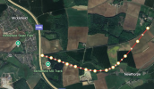
I would try and figure out a good way to grade separate the junction at Micklefield station, to ease the potential conflicts there. Maybe the best way is east of the A1(M), as shown below. (Maybe there are other ways.) Note: the dots are just the definition of the line in the view below, and not suggested pier locations.
1740404880047.png

Of course, with all that 4-tracking mentioned above, we would need to justify the expese. So we'll have to bring back
  • The line to Wetherby, Boston Spa and Tadcaster;
  • the line through Kippax and Allerton Bywater to Castleford (but meeting the Leeds-York line just west of Garforth instead of carving through the town, maybe with a new station at the Roundabout where Miller and Carter is currently),
 

YorksLad12

Established Member
Joined
5 Feb 2020
Messages
2,210
Location
Leeds
Expensive, but seriously expensive??
Apart from part of one inconsequential modern office building the route the south side of the viaduct looks clear - rather as though deliberately so (or the railway bought the land for quadruple??).
The only major issue would be the bridge that is being replaced over Marsh Lane, which would need to be replaced again as the added tracks would need to switch from south to north side of the current line.
While I'd like to see the viaduct widened to allow for parallel arrivals and departures, same as at the west end... it's not going to happen. You need space for the viaduct to be constructed as well as the thing itself, so...

Heading east over Briggate you'd have to demolish the two low-rise buildings on Call Lane, possibly also Revolution de Cuba. All the business under the arches (no longer owned by Network Rail, remember) would need to move out. Chancellor Court would lose one building and half of its car park. The car park off Wharf Street would go. The businesses under the arches on Church Walk would have to go. Then there's the dead - they got moved when the original viaduct went in, they won't be happy to be moved a second time. Surface car parks and under-arch businesses would go on Brussels Street. And once you hit Railway Street there's new apartments that wouldn't be happy with new railway going in outside their windows.

A couple of loops between Marsh Lane and Neville Hill would allow fast services to overtake delayed stoppers, and is a lot cheaper and less fuss!

West of Leeds.

With regard to the Princes Exchange building being sold to NR. I know that Regus (the serviced office building) were in some of the floors until recently. Their lease wasn't extended, and I think it came as a bit of a surprise to them. I agree that their car park would make a great place for some additional platforms.
Network Rail buying that building is odd, given that it was previously British Rail property (and the entrance to Red Star Parcels). I assume everyone is talking about the surface car parks next to P0 rather than the small car park outside the building itself! Even so; how do passengers access and exit any new platforms? The multi-storey car park would have to come down if the former Wellington platforms were reinstated somehow.
East of Leeds

4-tracking the whole of the viaduct East of Leeds station would obviously be very difficult, expensive and disruptive. I would instead start it just after the Mecca Bingo (just South of the bus station) to allow a new station on York Street. This would serve the areas around the bus station, Quarry House, Royal Armories, etc. This would either be a local passing loop, or (preferably) continue past Neville Hill depot to a new station at Killingbeck.
Too many new stations. Marsh Lane / Quarry Hill is always suggested, but you need land effectively for six tracks; two fast, two stopping plus platforms.
Of course, with all that 4-tracking mentioned above, we would need to justify the expese. So we'll have to bring back
  • The line to Wetherby, Boston Spa and Tadcaster;
  • the line through Kippax and Allerton Bywater to Castleford (but meeting the Leeds-York line just west of Garforth instead of carving through the town, maybe with a new station at the Roundabout where Miller and Carter is currently),
Tadcaster would be a dead end, and the former line built over; Wetherby would be in a cutting (and cut through a golf course and housing now on the way to Cross Gates); and Wetherby residents were up in arms when a light rail suggestion was made in the 1990s (I was on Leeds PCC at the time). Think we can discount that.

The route from Garforth to Castleford is mostly extant, but the only major settlement is Kippax. Which is in Leeds now, and is James Lewis's area (Leader of Leeds City Council). If he's not pushing for it, it's not going to happen, I think.
 
Last edited:

GingerSte

Member
Joined
26 May 2010
Messages
271
While I'd like to see the viaduct widened to allow for parallel arrivals and departures, same as at the west end... it's not going to happen. You need space for the viaduct to be constructed as well as the thing itself, so...

Heading east over Briggate you'd have to demolish the two low-rise buildings on Call Lane, possibly also Revolution de Cuba. All the business under the arches (no longer owned by Network Rail, remember) would need to move out. Chancellor Court would lose one building and half of its car park. The car park off Wharf Street would go. The businesses under the arches on Church Walk would have to go. Then there's the dead - they got moved when the original viaduct went in, they won't be happy to be moved a second time. Surface car parks and under-arch businesses would go on Brussels Street. And once you hit Railway Street there's new apartments that wouldn't be happy with new railway going in outside their windows.

A couple of loops between Marsh Lane and Neville Hill would allow fast services to overtake delayed stoppers, and is a lot cheaper and less fuss!


Network Rail buying that building is odd, given that it was previously British Rail property (and the entrance to Red Star Parcels). I assume everyone is talking about the surface car parks next to P0 rather than the small car park outside the building itself! Even so; how do passengers access and exit any new platforms? The multi-storey car park would have to come down if the former Wellington platforms were reinstated somehow.

Too many new stations. Marsh Lane / Quarry Hill is always suggested, but you need land effectively for six tracks; two fast, two stopping plus platforms.

Tadcaster would be a dead end, and the former line built over; Wetherby would be in a cutting (and cut through a golf course and housing now on the way to Cross Gates); and Wetherby residents were up in arms when a light rail suggestion was made in the 1990s (I was on Leeds PCC at the time). Think we can discount that.

The route from Garforth to Castleford is mostly extant, but the only major settlement is Kippax. Which is in Leeds now, and is James Lewis's area (Leader of Leeds City Council). If he's not pushing for it, it's not going to happen, I think.
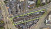
The land for the station at Quarry Hill (my suggestion)...
1740408543281.png
(Obviously I realise that this is not without disruption, but I think that this would be worth it.)

The Wetherby and Kippax lines were a bit tongue in cheek, at least at the moment. I would also add Allerton Bywater and Great Preston to Kippax on the list of places on that route, though.

With regard to the Princes Exchange building, I'm only relaying what I know, in that Regus (and their clients) did leave that building. Whether it was bought by NR is another matter, and would just be speculation on my part.
 

Trainman40083

Established Member
Joined
29 Jan 2024
Messages
2,292
Location
Derby
I remember when trains from Sheffield used to approach Leeds over the Holbeck viaduct.. Would there be any value in that route these days, or has the route been built on?
 

YorksLad12

Established Member
Joined
5 Feb 2020
Messages
2,210
Location
Leeds
The land for the station at Quarry Hill (my suggestion)...
View attachment 175218
I'd have put it on the old Marsh Lane site as there was space for a station already, there's almost level access off Railway Street and building on viaducts... well, see White Rose. Either way, it's got the potential to be Leeds's Deansgate.
 

skyhigh

Established Member
Joined
14 Sep 2014
Messages
6,333
With regard to the Princes Exchange building being sold to NR. I know that Regus (the serviced office building) were in some of the floors until recently. Their lease wasn't extended, and I think it came as a bit of a surprise to them. I agree that their car park would make a great place for some additional platforms.
I think there is a bit of a misunderstanding regarding which car parks belong to Princes Exchange. It's just the small car park in front of the building and the small car park that goes about halfway down platform 0.

The remainder of the surface car parking is for railway staff and has always been Network Rail property. I can't see how you could add additional platforms without taking a reasonable proportion of the staff car park and probably the multistorey too.
 

GingerSte

Member
Joined
26 May 2010
Messages
271
I remember when trains from Sheffield used to approach Leeds over the Holbeck viaduct.. Would there be any value in that route these days, or has the route been built on?

I think I saw on a previous thread that this viaduct has been assessed as not capable of withstanding train loads any more, due to its condition. (I don't know the details.)

I'd have put it on the old Marsh Lane site as there was space for a station already, there's almost level access off Railway Street and building on viaducts... well, see White Rose. Either way, it's got the potential to be Leeds's Deansgate.

That puts it further away from the parts that it would be serving, namely the bus station, market, area around the Playhouse, area around the Armouries. (I'm a firm believer in making easy connections between transport modes - it's why I'm not happy that none of the tram routes go near the station.) Plus, you've got what would be a horrible junction to cross on foot.

I would also say "out of sight, out of mind" in this case. In my suggestion, people in the bus station would easily see the station. (I'd actually put a footbridge between the bus and the rail stations). They would know about it, know how easy it was to catch a train. If the station was in it's old position, a lot of people wouldn't know about it, and know about the potential to change easily onto a train.

I think there is a bit of a misunderstanding regarding which car parks belong to Princes Exchange. It's just the small car park in front of the building and the small car park that goes about halfway down platform 0.

The remainder of the surface car parking is for railway staff and has always been Network Rail property. I can't see how you could add additional platforms without taking a reasonable proportion of the staff car park and probably the multistorey too.
Fair enough. I knew PE had some spaces, but didn't know that it wasn't all of them.
 

Attachments

  • 1740414347247.png
    1740414347247.png
    303.2 KB · Views: 35

Grumpy

Member
Joined
8 Nov 2010
Messages
1,173
Really interesting! Where was this station planned to be?
I don’t think anyone replied to this. I believe it probably referred to a proposed station at Thorpe Park. In recent years this area has had significant retail/office/residential investment. It also has good access to the M1 and the East Leeds Orbital road which in turn gives good road access to North and East Leeds. Given that Leeds Council are making it increasingly difficult to access Leeds station by car this might have had potential as a Parkway-type station
 

Bald Rick

Veteran Member
Joined
28 Sep 2010
Messages
32,057
The new viaduct at Borough Market junction managed to be poked through the existing buildings.

Where possible, yes. Where that wasn’t possible, they were demolished (or had a couple of floors lopped off).


Obviously I realise that this is not without disruption, but I think that this would be worth it.

I’m interested to know what your defintion of ‘worth it’ is in this example? It would be very, very expensive - I guess well into 9 figures for a two track / two platform station, and that station would reduce capacity on the line and be only 10 minutes walk from the main station, thereby the social benefit would most likely be negative.
 
Joined
5 Aug 2015
Messages
197
Location
Norfolk
4-tracking the whole of the viaduct East of Leeds station would obviously be very difficult, expensive and disruptive. I would instead start it just after the Mecca Bingo (just South of the bus station) to allow a new station on York Street. This would serve the areas around the bus station, Quarry House, Royal Armories, etc. This would either be a local passing loop, or (preferably) continue past Neville Hill depot to a new station at Killingbeck.

I would then 4-track from Cross Gates to just past the proposed new Thorpe Park Station. I agree with others that the stretch through Garforth and East Garforth stations would be expensive to do, and don't currently suggest it.

I would try and figure out a good way to grade separate the junction at Micklefield station, to ease the potential conflicts there. Maybe the best way is east of the A1(M), as shown below. (Maybe there are other ways.) Note: the dots are just the definition of the line in the view below, and not suggested pier locations.
View attachment 175213
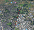
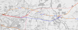
Yeah I was thinking something similar about a diversionary route, but maybe something much more substantial branching off like so:1740425398387.png

Not totally set on where it would end but most of it could be put in open countryside and avoid most of the stations. As this would be a fast lines diversion it could connect to the old hs2 alignment OR do its own thing towards Micklefield with some big junction worth there.1740425683153.png

Worst part would probably be the Grade 1 listed site at Temple Newsham, so that will likely need to be a tunnel. Although it may be quite difficult to place the ventillation/emergency exit shafts at that site (is it possible to be short enough to not have them?)
 

Top