• Our new ticketing site is now live! Using either this or the original site (both powered by TrainSplit) helps support the running of the forum with every ticket purchase! Find out more and ask any questions/give us feedback in this thread!

UK Train Network Map

Status
Not open for further replies.

OxtedL

Established Member
Associate Staff
Quizmaster
Joined
23 Mar 2011
Messages
2,603
So, about 4 hours ago now I was perusing the Route Coverage thread, pondering whether or not I should embarrass myself by revealing my route coverage. The outcome was of course no.

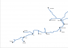
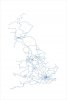
However, being of that disposition (the one where you compulsively make graphs to analyse threads), I wondered to myself: "Hmmmm, I wonder how hard it is to make a map of the UK train network in its entirety? I have half an hour spare, I'll give it a go."

Having worked Google Earth, Microsoft Word, Microsoft Excel and Paint to the death, I have produced this. It's not finished, it needs a bit of touching up (particularly on straight sections), but I thought you should see it anyway.

Comments? I do intend to put place names on it in the long term, but alas not yet.
 

Attachments

  • UK network.gif
    UK network.gif
    165 KB · Views: 306
Sponsor Post - registered members do not see these adverts; click here to register, or click here to log in
R

RailUK Forums

ralphchadkirk

Established Member
Joined
20 Oct 2008
Messages
5,755
Location
Essex
Looks very good! Now get back to analysing threads! :lol:

What did you use Excel in it for?
 

OxtedL

Established Member
Associate Staff
Quizmaster
Joined
23 Mar 2011
Messages
2,603
It went as follows:

  • Google Earth kml file
  • Word extracts coordinates
  • Excel draws coordinates as graph (yes, a graph :lol:)
  • Paint touches up gaps.

This version is slightly better, but will be of different quality, having uploaded as a PNG. Obviously not as useful as the one on route coverage...
 

Attachments

  • UK network.jpg
    UK network.jpg
    49.5 KB · Views: 143

Techniquest

Veteran Member
Joined
19 Jun 2005
Messages
21,670
Location
Nowhere Heath
Not even the Baker manages all three of your requirements there, as far as I know. It is however the most detailed UK rail atlas you'll get I reckon. In terms of free maps, OxtedL's map is very good!

Imagine how hard it would be to make if you included all of the non-passenger lines...! Very good work there so far, I'd love to see the finished version! I also didn't know you could do that with Excel, very funky!
 

Peter Mugridge

Veteran Member
Joined
8 Apr 2010
Messages
16,073
Location
Epsom
It is very good, yes. Looks a bit like a diagram of blood capilliaries in a biology textbook doesn't it? Alternatively, it reminds me a bit of the Vision On thing*.


*If you're under 40, you will not be familiar with this, so have a look here:
http://www.youtube.com/watch?v=WCYKGei2fyY


If you're over 40, apologies - you'll probably have the music in your head for the rest of the night now!
 

OxtedL

Established Member
Associate Staff
Quizmaster
Joined
23 Mar 2011
Messages
2,603
It's actually just a scatter graph in Excel, nothing hugely fancy... I need to go through Google Earth and put a whole ton of placemarks in now, so goodnight...
 

BlythPower

Member
Joined
15 Jan 2009
Messages
843
Location
Kenilworth
For my own coverage map, I've ripped off the National Rail map and drawn on freight only/diversionary routes where required. London's a bit of a blank on it though. N.B. attachment is shrunk to half size so a little blurry.
 

Attachments

  • UKRailMapCoverage50.gif
    UKRailMapCoverage50.gif
    546.7 KB · Views: 98

Ivo

Established Member
Joined
8 Jan 2010
Messages
7,307
Location
Bath (or Southend)
@OxtedL: I think I could have sussed how you made that, but it is very well done! I might have to try something similar for my own devices!

@BP: The number of times I've drawn on that map! :lol:
 

OxtedL

Established Member
Associate Staff
Quizmaster
Joined
23 Mar 2011
Messages
2,603
So, my place shortlist:
Code:
Penzance
Truro
Falmouth
Newquay
Par
Looe
Plymouth
Paignton
Newton Abbot
Exeter
Exmouth
Barnstaple
Okehampton
Taunton
Yeovil
Weston-super-Mare
Weymouth
Poole
Salisbury
Castle Cary
Westbury
Bath
Chippenham
Swindon
Bristol
Newport
*Cardiff
Bridgend
Ebbw Vale
Rhymney
Pontypridd
Swansea
Llanelli
Camarthen
Milford Haven
Fishguard
Pembroke Dock
Hereford
Llandrindod Wells
Shrewsbury
Machynlleth
Aberystwyth
Pwhelli
Blaenau Ffestiniog
Holyhead
Llandudno
Chester
Wrexham
Worcester
Gloucester
*Liverpool
Southport
Blackpool
Preston
Wigan
*Manchester
Buxton
Warrington
Crewe
Stoke-on-Trent
Stafford
Telford
Wolverhampton
Lichfield
Nuneaton
*Birmingham
Kidderminster
Stratford-upon-Avon
Leamington Spa
Banbury
Oxford
Bicester
Rugby
Northampton
Milton Keynes
Slough
Reading
Basingstoke
Alton
Romsey
Bournemouth
Southampton
Portsmouth
Ryde
Horsham
Chichester
Bognor Regis
Brighton
Seaford
Lewes
Eastbourne
Haywards Heath
Crawley
East Grinstead
Uckfield
Hastings
Tonbridge
Maidstone
Rye
Ashford
Dover
canterbury
Ramsgate
Margate
Faversham
Sheerness
Rochester
Southend
Shoeburyness
Chelmsford
Braintree
Sudbury
Colchester
Clacton-on-Sea
Harwich
Felixstowe
Ipswich
Stowmarket
Lowestoft
Great Yarmouth
Sheringham
Norwich
Thetford
Bury St Edmunds
Cambridge
Ely
Kings Lynn
March
Hitchin
Hertford
Stevenage
Royston
Bedford
Kettering
Corby
Leicester
Melton Mowbray
Peterborough
Spalding
Skegness
Sleaford
Grantham
Nottingham
Derby
Matlock
Chesterfield
Sheffield
Worksop
Newark
Lincoln
Retford
Gainsborough
Cleethorpes
Scunthorpe
Doncaster
Goole
Hull
Selby
Barnsley
Huddersfield
*Leeds
Bradford
Pontefract
York
Bridlington
Scarborough
Northallerton
Darlington
Bishop Auckland
Middlesborough
Whitby
Saltburn
Durham
Hartlepool
Sunderland
Newcastle
Alnwick
Berwick-on-Tweed
Dunbar
North Berwick
Edinburgh
Dumfermline
Kirkaldy
Cupar
Dundee
Arbroath
Montrose
Stonehaven
Aberdeen
Inverurie
Elgin
Nairn
Inverness
Dingwall
Lairg	
Helmsdale
Thurso
Wick
Kyle of Lochalsh
Aviemore
Pitlochry
Perth
Stirling
Alloa
Falkirk
Airdrie
Bathgate
Shotts
Crainlarich
Oban
Fort William
Mallaig
Balloch
Gourock
Wemyss Bay
Largs
Androssan
Ayr
Kilmarnock
*Glasgow
Carstairs
Stranraer
Dumfries
Lockerbie
Carlisle
Hexham
Workington
Barrow
Windermere
Oxenholme
Penrith
Kirkby Stephen
Settle
Skipton
Ilkley
Clitheroe
Carnforth
Morecambe
Blackburn
Colne
Todmorden

Any blinding ommisions (yes, tons missing from areas around starred places I know...)?
 

Ivo

Established Member
Joined
8 Jan 2010
Messages
7,307
Location
Bath (or Southend)
I would have to suggest the inclusion of Tilbury Town, and would question why Poole has been chosen ahead of Bournemouth. Not much though! In line with a certain other thread, you might want to check the spelling and capitalisation of a few of those, e.g. canterbury and Pwhelli! (Canterbury/Pwllheli)

It is looking very good so far!
 

OxtedL

Established Member
Associate Staff
Quizmaster
Joined
23 Mar 2011
Messages
2,603
I think Tilbury will be towards the edge of a London zoom side map.

I'm taking the policy not to bother with Town or North etc except in certain circumstances as it isn't worth the extra hassle and won't add much to the map.
 

me123

Established Member
Joined
9 Jul 2007
Messages
8,510
I'm not sure if you have all the ones in the Glasgow area, or if you're looking for them. I'd add the following from Scotland onto your list:

Springburn, Cumbernauld, Whifflet, (Paisley Gilmour Street), Paisley Canal, Newton, Neilston, Cathcart, East Kilbride, Anniesland, Milngavie, Helensburgh Central, Dalmuir, Motherwell, Larkhall, and Lanark. I think you've got it otherwise.
 

Techniquest

Veteran Member
Joined
19 Jun 2005
Messages
21,670
Location
Nowhere Heath
I agree that some of the other maps are well worth checking out. Just had a look at the Paris enlarged map, looks pretty detailed and worthy of use for a coverage map. I got a bit lost with it since I couldn't remember where I had and hadn't been over there, but eventually found the RER and everything fell into place. That guy's done some seriously massive amount of work!
 

OxtedL

Established Member
Associate Staff
Quizmaster
Joined
23 Mar 2011
Messages
2,603
OK, here's an early go at putting some of the places mentioned above on. Thoughts?
 

Attachments

  • FIRSTSHOTCLOSE.png
    FIRSTSHOTCLOSE.png
    37.2 KB · Views: 46
  • FIRSTSHOT.jpg
    FIRSTSHOT.jpg
    54.1 KB · Views: 40

HST Power

Established Member
Joined
25 Nov 2010
Messages
3,704
OK, here's an early go at putting some of the places mentioned above on. Thoughts?

It's good, but if you look at the posting boards, you will see I am hauling you in, so I'd get back to that! ;)
 

OxtedL

Established Member
Associate Staff
Quizmaster
Joined
23 Mar 2011
Messages
2,603
OK, can I have some feedback on this filled in Welsh version? I think I can squeeze a bit more in the Valleys, but plan to include a close up on Cardiff itself.

Any other comments welcome, particularly on place spacing, inappropriate places and so on...
 

Attachments

  • FIRSTSHOTWALESETC.jpg
    FIRSTSHOTWALESETC.jpg
    92.5 KB · Views: 39

ainsworth74

Forum Staff
Staff Member
Global Moderator
Joined
16 Nov 2009
Messages
28,959
Location
Redcar
It's looking pretty good so far Oxted, though it would be better if I didn't have to tilt my head 90 degrees to the side ;)
 

OxtedL

Established Member
Associate Staff
Quizmaster
Joined
23 Mar 2011
Messages
2,603
:lol:, sorry yes, it's just there is a bit of a limit on the resolution I can get posting on this forum. I haven't worked out how I'm going to get round it yet, but the solution will probably involve hacking Great Britain into lots of little pieces. So get ready for more thuds ;).
 

OxtedL

Established Member
Associate Staff
Quizmaster
Joined
23 Mar 2011
Messages
2,603
Yes, it's me again, you're not free of this yet... <D

This is what my Google Earth now looks like...
 

Attachments

  • Screenshot.png
    Screenshot.png
    607.5 KB · Views: 52

sprinterguy

Established Member
Joined
4 Mar 2010
Messages
11,304
Location
Macclesfield
Ahh... Blackpool, the end of the known Universe ;)
It certainly feels that way when you visit it!

Actually, that map is an excellent rendition of what a "proper" northerner would deem to be "The South".<D I reckon to save a bit of time, don't bother naming and locating the northern towns and just write "Here be dragons". :D

Impressive work OxtedL, the skill and tenacity required for such an undertaking would have gone completely over my head.
 

OxtedL

Established Member
Associate Staff
Quizmaster
Joined
23 Mar 2011
Messages
2,603
Thanks for your advice there everyone <D...
 

Attachments

  • dragons.png
    dragons.png
    703 KB · Views: 32

Techniquest

Veteran Member
Joined
19 Jun 2005
Messages
21,670
Location
Nowhere Heath
Not a bad result so far, and I laughed at the 'Here be dragons' thing. Perhaps I ought to have queried it at the time, but hey ho. Wales looks, well, dead in terms of names on the map. England however, generally speaking, is mahoosively populated with names!

However, it must be said that you recognised the full name of Llandrindod Wells and didn't simply refer to it as 'Llandrindod' as ATW do. Big thumbs up there from me! Perhaps adding one or two of the other big-ish places on the Central Wales wouldn't be a bad idea, if only to provide more of an outline of the Central Wales route. Same sort of principle applies to the Cambrian, it looks a little dead around there.

And before anyone says it, yes I know Wales is a bit of a railway desert in places! :lol:
 
Status
Not open for further replies.

Top