ccityplanner12
Member
- Joined
- 17 Feb 2016
- Messages
- 134
The area around New Malden Junction contains various piece of redundant railway infrastructure which aren't shown on any old maps to have ever accommodate a track.
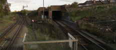
The first is the diveunder at the junction itself, which has an extra bore to accommodate a track diverging from the Up Kingston and heading for the downside of the main line.

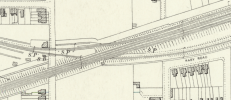
It would seem as though it was built to connect to the slow side before the flyover was built at Wimbledon. Before the flyover was built, however, the Up slow cross the fasts on the flat somewhere in the vicinity of Clapham Junction, and this section has always been direction-grouped, and Raynes Park station is laid out accordingly. The oldest map I can find, from the 1890s, shows the junction with exactly the same layout as it has presently, including the underpass being wide enough for two tracks though accommodating only one.

Also of notable on the above map is the wide strip of railside land beginning at Elm Road and extending to the east.

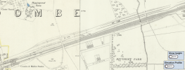
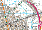
This parallels the railway all the way to West Barnes Lane. What's unusual about it is that someone's actually gone to the trouble of levelling this strip of land from end to end, as though it was intended to put tracks on it. All maps I can find show it in the same state it is in currently. The only thing I can think is that this must be the undertaking of the ill-fated Guildford, Kingston & London Railway. Today it has been put to use for a cycle route, taking advantage of the convenient cutting through Malden Hill and crossing of the Beverley Vale. This is the profile of where the strip of land cuts through. The strip itself is, of course, flat.

The first is the diveunder at the junction itself, which has an extra bore to accommodate a track diverging from the Up Kingston and heading for the downside of the main line.

It would seem as though it was built to connect to the slow side before the flyover was built at Wimbledon. Before the flyover was built, however, the Up slow cross the fasts on the flat somewhere in the vicinity of Clapham Junction, and this section has always been direction-grouped, and Raynes Park station is laid out accordingly. The oldest map I can find, from the 1890s, shows the junction with exactly the same layout as it has presently, including the underpass being wide enough for two tracks though accommodating only one.

Also of notable on the above map is the wide strip of railside land beginning at Elm Road and extending to the east.

This parallels the railway all the way to West Barnes Lane. What's unusual about it is that someone's actually gone to the trouble of levelling this strip of land from end to end, as though it was intended to put tracks on it. All maps I can find show it in the same state it is in currently. The only thing I can think is that this must be the undertaking of the ill-fated Guildford, Kingston & London Railway. Today it has been put to use for a cycle route, taking advantage of the convenient cutting through Malden Hill and crossing of the Beverley Vale. This is the profile of where the strip of land cuts through. The strip itself is, of course, flat.


