• Our booking engine at tickets.railforums.co.uk (powered by TrainSplit) helps support the running of the forum with every ticket purchase! Find out more and ask any questions/give us feedback in this thread!

Walking and Rambling discussion

ChrisC

Established Member
Joined
7 Oct 2018
Messages
1,616
Location
Nottinghamshire
I am 61, so I haven’t got a free pass yet, but do qualify for the Derbyshire Wayfarer concession rate of £6.70, which was excellent value for three buses.
It’s a fantastic value ticket for anyone over 60 who doesn’t yet qualify for an ENCTS pass. I use it regularly when I go out walking in any part of Derbyshire. As I live in Nottinghamshire I do have to drive a few miles to park up over the border in Derbyshire, but I know a quiet safe road near Alfreton where I’m quite happy to leave my car all day. I will probably continue to use it even when I do get my bus pass as it allows travel before 9.30am and I do like an earlier start if I’m going out for the day. Even if I’m only planning on using Stagecoach or Trent Barton buses it’s cheaper than their day tickets.
 
Sponsor Post - registered members do not see these adverts; click here to register, or click here to log in
R

RailUK Forums

S&CLER

Member
Joined
11 Jan 2020
Messages
785
Location
southport
I did two excellent walks while on holiday in Llandrindod. One was from Llandrindod to Builth Wells via the hills (the Carneddau) and a lovely contour path round a hillfort overlooking the valley of a tributary of the Wye just north of Builth. The other was from Newbridge on Wye down the valley to Builth (chosen because there are more buses back from Builth to Llandrindod than from any other nearby town). The first walk was hard, especially through dense bracken alongside the fence which marked the boundary of access land, and which we had to follow; it would be easier in winter when the bracken has died down. Definitely an area to go back to.
Yesterday I led the Ramblers' C party, including two young children, the older having his 7th birthday, on an easy level walk from the A590 near the Gilpin Bridge hotel to Grange over Sands via Foulshaw lane and the dyke on the bank of the river Kent, opposite Arnside. The boys were delighted to see a train cross Arnside viaduct while we were having our lunch.
I've also done good walks from Kilnsey to Conistone and Kettlewell in Wharfedale and around Lantern Pike at Hayfield, Derbyshire recently. One of the best short walks I've ever done was a recent walk from Millport on the island of Great Cumbrae, along the quiet lane up the middle of the island to the superb viewpoint called the Glade Stane and down to the ferry slip for Largs at the other end of the island. Takes about 80 minutes and can be done in ordinary shoes.
 
Last edited:

THC

Member
Joined
21 Sep 2009
Messages
471
Location
Stuck on the GEML
Cressing to Chappel. Fourteen miles along the Essex Way footpath on a lovely autumn (birth)day.

THC
 

Attachments

  • Screenshot_20221007-214352.png
    Screenshot_20221007-214352.png
    323.6 KB · Views: 15

Kite159

Veteran Member
Joined
27 Jan 2014
Messages
19,273
Location
West of Andover
Did another large step with the Thames Path covering from Culham towards Oxford (started the walk at Didcot Parkway, following bike route 5 towards Appleford, then a couple footpaths towards Sutton Courtney to reach the Thames on the Culham Cut. That clears the Thames Path from Oxford all the way to Leamouth in London [where the 'north bank' Thames Path ends]. Next step will be to do the southern bank to that eastern end near the mouth of the Darent.

Beautiful sunny weather for a rural walk. Beyond Oxford the Thames Path gets a bit more difficult as buses will need be involved as the Thames goes away from the railway
 

32475

Member
Joined
2 Nov 2019
Messages
743
Location
Sandwich
In Scotland for a few days to see my son so we took the train up to Pitlochry for a circular walk up Ben Vrackie then descended to the Pass of Killiekrankie alongside the River Garry back to Pitlochry for a well earned pint. 15 miles in all and plenty of highlights including a red squirrel, a herd of deer sweeping past us, the south portal of Killiekrankie tunnel and the adjacent viaduct.
9F5BAC7C-1D1F-47F9-A485-E9D94DF9F0DF.jpegAD679B0B-F878-42CD-AF75-421D7C3554AC.jpeg9BDBA34D-B78B-42DA-AF20-74F63473BC54.jpeg
 

Galvanize

Member
Joined
8 Jun 2005
Messages
1,100
Location
South East london
This Saturday just gone, while staying in Newport South Wales…I walked to the top of Sugar Loaf Mountain overlooking Abergavenny. Not to be confused with the one overlooking the Heart of Wales Line!

The weather was initially quite miserable first thing…I nearly didn’t bother going…but it brightened up…the cancellation of the 10:07 from Newport almost also made me change my mind, but I persisted. Very glad that I did, despite the steep steep climbs…the views were amazing. On the way down, stopped off for Tea in The Vineyard (convenient as the rain came down at that point!)…then once reaching Abergavenny, couple of pints of Wye Valley Ales at The Station Hotel. D672D563-ABF2-4E3A-8C71-1B28A869FA5A.jpegF3A00384-B909-49B3-B141-AAC24501DA19.jpeg5F741D69-1B5B-4104-9711-D568A26F0D6C.jpeg
 

High Dyke

Established Member
Joined
1 Jan 2013
Messages
4,283
Location
Yellabelly Country
Forgot to post this before, but on the funeral day of HM the Queen, and day after I was completing the last two sections of the Capital Ring, around London. Views along both sections.

20220919_103521.jpg 20220919_105205.jpg 20220919_112124.jpg 20220919_133314.jpg 20220920_101056.jpg 20220920_111053.jpg 20220920_115939.jpg 20220920_124930.jpg 20220920_125404.jpg20220920_130156.jpg

Pictures:
  • Mural at Hackney Wick station
  • Old Ford Lock
  • Old turbine from Abbey Mills pumping station
  • DLR train approaches Royal Albert station
  • Capital Ring signpost (changeover from Section 14 and section 15)
  • University of East London building, acknowledging the heritage of the docks area
  • Aircraft approached London City Airport
  • (Former) North Woolwich Station
  • Woolwich Foot Tunnel
  • Signpost at the end of Section 15 / commencement of Section 1. The brick building behind is the South access to the Foot Tunnel.
 
Last edited:

Ediswan

Established Member
Joined
15 Nov 2012
Messages
2,858
Location
Stevenage

Yew

Established Member
Joined
12 Mar 2011
Messages
6,552
Location
UK
I'm currently in Aix-en-Provance, and had a lovely walk up to the site where Cezanne painted a few landscapes, then over to the actual landscapes to walk up a nice viewpoint.

Unfortunately the path was not signposted and I ended up on someones back garden on the way down!
 

davews

Member
Joined
24 Apr 2021
Messages
652
Location
Bracknell
Ah, the famous sign at Woolwich where the pointers keep moving around, never in the same direction and never in the correct one. Been like that for years.
 

Birmingham

Member
Joined
14 Mar 2020
Messages
495
Location
United Kingdom
Ah, the famous sign at Woolwich where the pointers keep moving around, never in the same direction and never in the correct one. Been like that for years.
Oh really? I’m glad it’s not just me. :lol: I had no end of trouble when I tried to begin the Capital Ring route from Woolwich some time ago. I think there were also loads of works going on around the beginning of the route which made it difficult to stay on track.
 

philjo

Established Member
Joined
9 Jun 2009
Messages
2,892
A 11.5 mile ciircular walk today from Clapham village via Gaping Gill to the summit of Ingleborough and returning on the path down towards Horton before taking the Pennine Bridleway path back to Clapham.
 

eMeS

Member
Joined
12 Jun 2011
Messages
954
Location
Milton Keynes, UK
A 11.5 mile ciircular walk today from Clapham village via Gaping Gill to the summit of Ingleborough and returning on the path down towards Horton before taking the Pennine Bridleway path back to Clapham.
How's the path up Ingleborough?
I was last there around 30 years ago when it was being "improved" to look more like a Milton Keynes Redway with heavily engineered surfaces; and for me totally out of keeping with a path near the top of a mountain. I hope it's now blended in.
 

THC

Member
Joined
21 Sep 2009
Messages
471
Location
Stuck on the GEML
Two days walking on the towpath of the south Leicester Line of the Grand Union Canal, starting from Long Buckby on Friday through a soaking to an overnight stay in Welford (21 miles) and then onto Market Harborough (17 miles) on a much drier and sunnier Saturday.

THC
 

Attachments

  • Screenshot_20221022-192402.png
    Screenshot_20221022-192402.png
    342.6 KB · Views: 8
  • Screenshot_20221021-192637.png
    Screenshot_20221021-192637.png
    496.9 KB · Views: 8
Last edited:

Kite159

Veteran Member
Joined
27 Jan 2014
Messages
19,273
Location
West of Andover
Quite good distances there @THC

I made the most of the sunshine on Saturday to do Littleborough to Manchester Piccadilly along the Rochdale Canal. Surface was decent enough, few little puddles [especially under bridges], hardest part was the wet leaves in the woodland sections near Rochdale & Oldham. A mix of rural, woodland, old industrial & modern houses

I ditched my original idea to do Crewe - Sandbach [via some footpaths] then towards Alsager along some disused railway routes due to the heavy rain, although I did manage to do a small section in Birmingham walking from New Street towards Digbeth then onwards to Aston. Walls/bridges near to the Canal was very heavily Graffitied but you can see where in the olden days there used to be a lot more basins from where the towpath goes up and over a bricked up arch.
 

Kite159

Veteran Member
Joined
27 Jan 2014
Messages
19,273
Location
West of Andover
Has the Rochdale Canal been cleared now? I remember it being a total mess back in the late 1950s.
It was reasonable in terms of quality, a few shopping trolleys in the canal at the Manchester end.

However I only saw one boat on the move and hardly anything moored up, but then I can't really judge a canal by how busy it is during October time when some boats would have been wrapped up for the winter months
 

johnnychips

Established Member
Joined
19 Nov 2011
Messages
3,679
Location
Sheffield
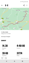
I had a ticket today that I could use to anywhere in Belgium, so I took it from Gent to Hergenrath, just short of the German border near Aachen. I looked for a walking route, and found to my delight I could walk to Aachen via the ‘Dreilaenderecke’ where three countries - the Netherlands, Belgium and Germany meet.
About half was on roads walking to the nearest town, Kelmis, from the station, as Hergenrath is a small village. Then it was a steady, not steep, walk up through dry woodland tracks.
At the top was a stone marking the three countries’ borders touching, cafes, car parks and an observation tower that I climbed as the lift was broken. As a bonus, I discovered that I had conquered the summit of the Netherlands.
A descent through the woods in Germany led to the road into Aachen and I walked along it into the city centre. About 15km, a very enjoyable day. On the map attached, the three-country- boundary is at the very top and Hergenrath station bottom right.
PS: I was going to get a bus from Aachen to Eupen in Belgium to pick up the train there, but of course you need a mask in Germany, and I hadn’t got one. So I bought a ticket at Aachen station back to Hergenrath for an eye-watering €7.60 for nine minutes on an ancient EMU with concertina doors. The guard told me I should have bought it off him for half the price. 715C7CA9-3471-4757-90B9-8682364BDDA8.jpegEFC67BD8-F09A-480C-B1CF-E939610D4D2C.jpeg
 

Kite159

Veteran Member
Joined
27 Jan 2014
Messages
19,273
Location
West of Andover
Last weekend I finished the Basingstoke Canal, including the section beyond Greywell tunnel. Although probably doing some of the more rural paths between Winchfield & Hook area + from the end of the canal towards Basingstoke after a couple days of heavy rain wasn't the best due to the mud (and some poor stiles).

Yesterday (Sunday) I was originally going to do the "Thames Down" link path from Tolworth towards Box Hill [leaving the section from Kingston to Tolworth for the time I do the London Loop as its shared] but decided to switch over to do the former Luton, Dunstable & Welwyn Railway route from Welywn Garden City towards Luton Airport [a beautiful Ayot Greenway to Wheathampstead (with a detour to the former station), followed by a muddy path across a field before rejoining the former railway route towards Luton Airport [where it's called the "Upper Lea Valley Way"]. Once at Luton Airport I carried along with the Lea Valley Way towards the source of the River Lea near Leagrave [heading via Luton town centre & a couple nice looking parks]. Although it was longer than expected, clocking in at just over 20 miles.

I suspect at some-point I will do the disused railway route from Welwyn heading towards Hertford, at least that won't be as expensive as I can use a day return to Stevenage [stopping short on the way to Stevenage, and starting late on the return, but now the clocks have gone back I need to watch the clock to ensure I don't get caught out in the darkness.
 

eMeS

Member
Joined
12 Jun 2011
Messages
954
Location
Milton Keynes, UK
...but decided to switch over to do the former Luton, Dunstable & Welwyn Railway route from Welwyn Garden City towards Luton Airport [a beautiful Ayot Greenway to Wheathampstead (with a detour to the former station), followed by a muddy path across a field before rejoining the former railway route towards Luton Airport [where it's called the "Upper Lea Valley Way"]. ...
I remember visiting the old station at Wheathampstead many years ago, and then it needed better labelling, although we did find it. How was it on your visit?
 

Kite159

Veteran Member
Joined
27 Jan 2014
Messages
19,273
Location
West of Andover
I remember visiting the old station at Wheathampstead many years ago, and then it needed better labelling, although we did find it. How was it on your visit?
From the path it wasn't that clearly labelled but the station was quite nice. Especially with the old wagon.
 

Birmingham

Member
Joined
14 Mar 2020
Messages
495
Location
United Kingdom
Last weekend I finished the Basingstoke Canal, including the section beyond Greywell tunnel. Although probably doing some of the more rural paths between Winchfield & Hook area + from the end of the canal towards Basingstoke after a couple days of heavy rain wasn't the best due to the mud (and some poor stiles).
How do you get to the beginning of the canal (Basingstoke end) by public transport? Easy enough from Fleet eastwards but the beginning seems rather rural.
 

_toommm_

Established Member
Joined
8 Jul 2017
Messages
5,856
Location
Yorkshire
Just a shorter walk for me whilst I get back into walking after I injured my knee at work - 7.5mi from Hessle to New Holland, via the Humber Bridge. A walk that took just over two hours; by train (with TPEs cancellations), possibly all day.

(The photo below is a screenshot of the route I took on the above walk, taken from the ‘Fitness’ app on my iPhone):

16D7A3B6-3437-4314-BEC9-ECECAB71BBE4.jpeg
 

Kite159

Veteran Member
Joined
27 Jan 2014
Messages
19,273
Location
West of Andover
How do you get to the beginning of the canal (Basingstoke end) by public transport? Easy enough from Fleet eastwards but the beginning seems rather rural.
Closest station is Hook, closest bus stop to Up Nately where the canal has water in it (nature reserve) is on a route 13 bus from Basingstoke to Alton on a stop called Blackstocks Lane on the A30.
 

THC

Member
Joined
21 Sep 2009
Messages
471
Location
Stuck on the GEML
Closest station is Hook, closest bus stop to Up Nately where the canal has water in it (nature reserve) is on a route 13 bus from Basingstoke to Alton on a stop called Blackstocks Lane on the A30.
Or make a walk of contrasts and start from Basingstoke station, working out from there to Up Nately along the detailed route suggested at https://en.m.wikipedia.org/wiki/Basingstoke_Canal - there are still bits and pieces of the original line where you might not expect them! - and then the old towpath can be found to take you up and over Greywell tunnel and onto the canal proper.

THC
 
Last edited:

D365

Veteran Member
Joined
29 Jun 2012
Messages
11,472
On the topic of canals. Is the Tinsley Canal towpath still shut?

This site indicates that the works should have finished months ago.
 

johnnychips

Established Member
Joined
19 Nov 2011
Messages
3,679
Location
Sheffield
About three weeks ago, it was still boarded off. As was the section in Rotherham near the New York stadium (so I had to take quite a diversion via Masbrough instead). Of course things might have changed since.
 

AndrewE

Established Member
Joined
9 Nov 2015
Messages
5,100
Just a shorter walk for me whilst I get back into walking after I injured my knee at work - 7.5mi from Hessle to New Holland, via the Humber Bridge. A walk that took just over two hours; by train (with TPEs cancellations), possibly all day.

(The photo below is a screenshot of the route I took on the above walk, taken from the ‘Fitness’ app on my iPhone):

View attachment 122969
That really looks like drudgery, and possibly not good for leg or knee-joint recuperation either.
I prefer to cycle ex-railway lines and anything like your walk (I cycled the old Severn Bridge over to Chepstow and back in July 1974. I can't imagine walking it!)

My last walk (apart from Musselburgh station to the town centre along the riverside cycle route 3 days ago) was a train- and bus-assisted trip with an old schoolfriend from Cowroast to Buckland Wharf. Lots of reminiscences about when we used to play on the recently-withdrawn BWB narrowboats tied up along the Wendover arm, and how good it was to see the canal (mostly dry in our childhood) being returned to water.
A
 

Top