Iskra
Established Member
Thanks guys!


Keep it up, Peter!
I would do that if I knew how, but I'm afraid my computer skills aren't up to it. But I enjoy your walk descriptions and maps. When my walking partner, an IT professional with Hewlett Packard, was still alive, he used to print out colour OS maps with the route highlighted, directional arrows at half-mile intervals and a gradient profile as well. He had desk-top publishing software, so our descriptive handouts for the walks we led with our club, printed on glossy paper, looked very smart.It's all rather weather dependent... if there's been heavy rain in the couple of days before a walk, then even if it's a dry day on the Saturday we'd probably not do one that involves towpaths as they have a habit of turning into a series of awkward muddy puddles in such conditions! We do have back up plans ready for just such circumstances, though.
One thing I'd like to see would be others who describe their walks putting up maps of them as well, not necessarily the same way that I do, but maps would help others looking at doing the same or similar walks.
Ah, what I'm doing is I'm finding the area of the walk on Google Maps ( searching by a nearby area so I don't get the big red balloon pin marker in the way ) and then using the snipping tool to select the relevant area and marking the route with the pen function contained within the snipping tool.I would do that if I knew how, but I'm afraid my computer skills aren't up to it. But I enjoy your walk descriptions and maps. When my walking partner, an IT professional with Hewlett Packard, was still alive, he used to print out colour OS maps with the route highlighted, directional arrows at half-mile intervals and a gradient profile as well. He had desk-top publishing software, so our descriptive handouts for the walks we led with our club, printed on glossy paper, looked very smart.
I would do that if I knew how, but I'm afraid my computer skills aren't up to it. But I enjoy your walk descriptions and maps. When my walking partner, an IT professional with Hewlett Packard, was still alive, he used to print out colour OS maps with the route highlighted, directional arrows at half-mile intervals and a gradient profile as well. He had desk-top publishing software, so our descriptive handouts for the walks we led with our club, printed on glossy paper, looked very smart.
I find the "OS Maps" app fantastic. It costs £19.99 per year which I think is a bargain. You get "Explorer" mapping of the whole country and you can zoom in to check exact routes of footpaths. I plan routes on my laptop and then download the area I am going to walk on my mobile before starting, in case cellular coverage is poor. On the ground the screen shows where you are relative to the path and the direction you ae going. (The only thing it doesn't do is set the map with north in the correct direction).Ah, what I'm doing is I'm finding the area of the walk on Google Maps ( searching by a nearby area so I don't get the big red balloon pin marker in the way ) and then using the snipping tool to select the relevant area and marking the route with the pen function contained within the snipping tool.
I find the "OS Maps" app fantastic. It costs £19.99 per year which I think is a bargain. You get "Explorer" mapping of the whole country and you can zoom in to check exact routes of footpaths. I plan routes on my laptop and then download the area I am going to walk on my mobile before starting, in case cellular coverage is poor. On the ground the screen shows where you are relative to the path and the direction you ae going. (The only thing it doesn't do is set the map with north in the correct direction).
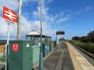
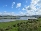
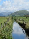
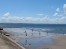
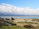
I'm envious! Had several pleasant holidays at Grange during WWII, and I remember the seaside baths, and pond with ducks in Grange. My last visit to the area, was to Carnforth Station to capture an LMR 4-6-2 hauled "The Caledonian" express powering through. Can't remember the date.Today's walk, postponed from a very wet yesterday, took me from Cark station to Grange over Sands via the Cumbrian Coastal Way. ... Total time 3 hrs 28 minutes.


Have you got the negative ? A modern scanner might work wonders on the colour and dust/scratches.I'm envious! Had several pleasant holidays at Grange during WWII, and I remember the seaside baths, and pond with ducks in Grange. My last visit to the area, was to Carnforth Station to capture an LMR 4-6-2 hauled "The Caledonian" express powering through. Can't remember the date.View attachment 99245
I must have it somewhere (actually it's a slide), and my scanning skills are much better now than they were. Is it worth my time? Not sure...Have you got the negative ? A modern scanner might work wonders on the colour and dust/scratches.