• Our booking engine at tickets.railforums.co.uk (powered by TrainSplit) helps support the running of the forum with every ticket purchase! Find out more and ask any questions/give us feedback in this thread!

CODE BLACK- "DO NOT TRAVEL" GWR Sunday 18/02/2024

father_jack

Member
Joined
26 Jan 2010
Messages
1,130
Flooding Alderton Tunnel between Bristol Parkway and Swindon.
Flooding one track Dauntsey between Chippenham and Swindon.
Flooding Athenley between Taunton and Westbury.

Planned engineering work Bath to Westbury stuffs everything completely.

Climate change or Network Rail cutbacks to preventative drain clearing ?


Due to flooding between Swindon and Chippenham the line towards Chippenham is blocked.
Impact:
Train services running through these stations may be cancelled or delayed. Disruption is expected until 12:00 18/02.
Customer Advice:
We're sorry for the delay to your journey.
Owing to flooding in the Dauntsey area one of the two line between Swindon and Chippenham is closed.
Flooding is also affecting the alternative routes which we would have used to divert services along.
A very limited train service will be running between Swindon and Bristol Temple Meads via Chippenham and Bath Spa, in both directions.
You are advised not to attempt to travel at this time.
We will update this message with more information when we have it.
Due to flooding between Swindon and Bristol Parkway the line is blocked. Disruption is expected until 12:00 18/02.
Impact:
Train services between London Paddington and Cardiff Central via Bristol Parkway may be delayed or diverted.
Customer Advice:
We're sorry for the delay to your journey.
Owing to flooding in the Alderton area the line between Swindon and Bristol Parkway is closed.
Flooding is also affecting the line between Swindon and Chippenham, which is the alternative line we would use when the line between Swindon and Bristol Parkway is closed. We can only use one of the two lines on that alternative route so only a very limited train service will be running between London Paddington and South Wales in both directions.
You are advised not to attempt to travel at this time.
We will update this message with more information when we have it.
Due to flooding between Taunton and Castle Cary the Reading line is blocked. Disruption is expected until 12:00 18/02.
Impact:
Train services between Taunton and Westbury may be delayed by up to 60 minutes.
Customer Advice:
We're sorry for the delay to your journey.
Owing to flooding in the Somerton area the line between Taunton and Castle Cary had been closed. The water level has reduced and the line is now being inspected by Network Rail. When it reopens trains will have to run at a much reduced speed which will extend journey times.
We will update this message with more information when we have it.
 
Sponsor Post - registered members do not see these adverts; click here to register, or click here to log in
R

RailUK Forums

stuu

Established Member
Joined
2 Sep 2011
Messages
2,776
Climate change or Network Rail cutbacks to preventative drain clearing ?
A bit of both probably. The whole SW has had 133% of normal rainfall in the last 3 months, the ground around here is absolutely saturated, so any new rain runs straight off the land. Wetter winters are a prediction of climate change modelling. But we know maintenance has been cut back so could be equally the problem
 

Irascible

Established Member
Joined
21 Apr 2020
Messages
2,015
Location
Dyfneint
The whole SW has had 133% of normal rainfall in the last 3 months, the ground around here is absolutely saturated, so any new rain runs straight off the land

This does seem to happen regularily down here now though, at some point it has to be considered "normal".
 

The Planner

Veteran Member
Joined
15 Apr 2008
Messages
16,022
Depends on the level of rainfall they have had in short period of time, drainage can only handle so much. Badminton has had 20mm of rain in the last 24 hours. Wootton Bassett 56.6mm. Somerton 27.7mm, Bruton 31.2mm, Frome 37.8mm, Great Somerford 49.8mm.
 

unlevel42

Member
Joined
5 May 2011
Messages
543
133% over 3 months should be well within contingency planning and will not be the direct.
 

Mountain Man

Member
Joined
15 Jun 2019
Messages
341
133% over 3 months should be well within contingency planning and will not be the direct.
The direct cause is rain in recent days.

Neither investment nor climate change are the direct causes. But both are contributing factors which is what matters
 

Taunton

Established Member
Joined
1 Aug 2013
Messages
10,124
Flooding Alderton Tunnel between Bristol Parkway and Swindon.
Flooding one track Dauntsey between Chippenham and Swindon.
Flooding Athelney between Taunton and Westbury.

Planned engineering work Bath to Westbury stuffs everything completely.

Climate change or Network Rail cutbacks to preventative drain clearing ?
Alderton Tunnel is the shorter one, just east of Chipping Sodbury Tunnel, which has been nothing but trouble due to flooding ever since the day that cheapskate GWR engineer Grierson had it designed and dug around 1900, well after basic railway engineering principles were understood. This is north of the better known Box Tunnel, by Brunel 60 years beforehand, through the same ridge of the Cotswolds - which I don't recall has ever had flooding issues.

Grierson also engineered, and at the same time, the Somerton Cutoff on the Taunton line, where flooding at Athelney has also been a constant issue. It was always a great source of weekend overtime for the Taunton pw gang, and countless wagonloads of ballast have gone into The Levels there over time, and vanished into the quagmire. Strangely it's another section where the Brunel-engineered old line from Bristol to Taunton is almost parallel, over the same Levels, and once again has had nothing like these flooding issues. And hey-ho, here we are again.

Incidentally, if you want to know what the Taunton pw gang said, a generation ago, was the basic issue there, it was that it was built about four feet too low over a known flood plain, not enough spent on embankment material (which Brunel had dug out from borrow pits alongside the line on the Bristol route, some still visible - https://www.bankrate.com/real-estate/what-is-a-borrow-pit/ ), and thus insufficient drainage to the winter water table. Maybe Grierson, daddy being the General Manager of the GWR in the late 1800s, didn't pay sufficient attention in his civil engineering lectures. No wonder loco engineer Churchward despised him, and they apparently hardly spoke.
 
Last edited:

Mcr Warrior

Veteran Member
Joined
8 Jan 2009
Messages
11,922
Chipping Sodbury Tunnel, which has been nothing but trouble due to flooding ever since the day that cheapskate GWR engineer Grierson had it designed and dug around 1900, well after basic railway engineering principles were understood.
What's the back story there? Have to say that it's not a section of the GB network that I've ever used myself.
 

philosopher

Established Member
Joined
23 Sep 2015
Messages
1,355
Flooding Alderton Tunnel between Bristol Parkway and Swindon.
Flooding one track Dauntsey between Chippenham and Swindon.
Flooding Athenley between Taunton and Westbury.

Planned engineering work Bath to Westbury stuffs everything completely.

Climate change or Network Rail cutbacks to preventative drain clearing ?
The last 12 months have been very wet, I don’t think I have ever know such a lengthy spell of persistently above average rainfall. Until the weather gods decide that the UK has had enough excess rain, these sort of issues are going to keep occurring.
 

Taunton

Established Member
Joined
1 Aug 2013
Messages
10,124
The last 12 months have been very wet, I don’t think I have ever know such a lengthy spell of persistently above average rainfall. Until the weather gods decide that the UK has had enough excess rain, these sort of issues are going to keep occurring.
However it may feel, the statistics show things are pretty normal

This well-established weather site in London keeps immaculate records against, the long term norms, and shows the rainfall in the last 12 months has been just 105% of the norm - hardly any difference at all. same true of previous years.


Attachments

  • Rainfall.JPG
    Rainfall.JPG
    66.5 KB · Views: 51

mrcheek

Established Member
Joined
11 Sep 2007
Messages
1,472
Regardless of how much rain we have had over the last year, or the last 3 months, yesterday afternoon and last night it rained non stop in the south west
 

Class 170101

Established Member
Joined
1 Mar 2014
Messages
7,959
But it is still possible to reach Taunton (and beyond) albeit via roundabout route currently.

Paddington to Gloucester and then Gloucester to Taunton via Bristol Parkway and Temple Meads but I bet there aren't any services diverting this way.

(NB should the Single Line through Chippenham fall)
 

brad465

Established Member
Joined
11 Aug 2010
Messages
7,076
Location
Taunton or Kent
However it may feel, the statistics show things are pretty normal

This well-established weather site in London keeps immaculate records against, the long term norms, and shows the rainfall in the last 12 months has been just 105% of the norm - hardly any difference at all. same true of previous years.

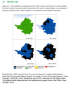
I'd be looking at the Environment Agency's Water Situation reports for this, where if we look at the Wessex area specifically (which covers most of the geographical areas this current flooding disruption is occurring in), the 12 month period of 2023 was the 6th-wettest on record, even though January was fairly average:


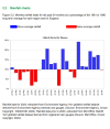
This particular map and chart from the report is useful, highlighting how the last 12 months have been "Exceptionally High", and October-December all logged over 150% of the average:

1708254810299.png
(Image of Environment Agency Wessex area map showing total rainfall for hydrological areas for December 2023 and the last 3, 6 and 12 months relative to the historical totals.

1708254853140.png
(Image showing bar chart of Wessex area rainfall, each bar representing a month and showing the totals received relative to normal, with blue bars above average and red below).

There are plenty of other maps/charts in the report linked above, but these two are probably the most relevant.

Anyone who regularly uses the railway between Castle Cary and Taunton during wet periods will have experienced the sight of vast expanses of water across the Somerset levels, especially between Langport and Cogload Jct. There is also a flood storage reservoir in the Athelney area which can be clearly seen from the railway, and is most notable when in full storage as the trees in it are half submerged. For those who haven't seen it before, here's a recent example of this:

20231106_161404.jpg
(Image of flood storage reservoir filled near Cogload Jct on the Reading-Taunton line)
 

geoffk

Established Member
Joined
4 Aug 2010
Messages
3,267
Alderton Tunnel is the shorter one, just east of Chipping Sodbury Tunnel, which has been nothing but trouble due to flooding ever since the day that cheapskate GWR engineer Grierson had it designed and dug around 1900, well after basic railway engineering principles were understood. This is north of the better known Box Tunnel, by Brunel 60 years beforehand, through the same ridge of the Cotswolds - which I don't recall has ever had flooding issues.

Grierson also engineered, and at the same time, the Somerton Cutoff on the Taunton line, where flooding at Athelney has also been a constant issue. Strangely it's another section where the Brunel-engineered old line from Bristol to Taunton is almost parallel, over the same Levels, and once again has had nothing like these flooding issues.
Interesting. And the Gloucestershire-Warwickshire Railway has had major problems with failure of the embankments near Winchcombe (Chicken Curve) and Gotherington on a line built by the GWR during the same period (1904-6).
 
Last edited:

dk1

Veteran Member
Joined
2 Oct 2009
Messages
16,060
Location
East Anglia
I think anybody who paid attention to the weather forecast yesterday didn’t expect things to be plain sailing (excuse the pun) today.
 

Jimini

Established Member
Joined
8 Oct 2006
Messages
1,408
Location
London
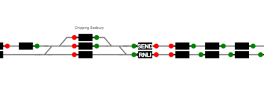
Nice to see the control room (TVSC?) have a sense of humour about these things :lol:


Flood.png


Image is a snip of the area in Traksy, with "SEND" and "RNLI" in one of the flooded sections.
 

Taunton

Established Member
Joined
1 Aug 2013
Messages
10,124
Interesting. And the Gloucestershire-Warwickshire Railway has had major problems with failure of the embankments near Winchcombe (Chicken Curve) and Gotherington on a line built by the GWR during the same period (1904-6).
Yes, another Grierson-era line. The GWR invested a very considerable amount in that era into new direct main lines at that time. The closure of the Badminton line for more than a year in the mid-1970s, for the introduction of HSTs, was meant to be a "once and for all" fixing of the various civils issues along it.
 

dk1

Veteran Member
Joined
2 Oct 2009
Messages
16,060
Location
East Anglia
Yes, another Grierson-era line. The GWR invested a very considerable amount in that era into new direct main lines at that time. The closure of the Badminton line for more than a year in the mid-1970s, for the introduction of HSTs, was meant to be a "once and for all" fixing of the various civils issues along it.

They always say that then a few decades later…
 

Taunton

Established Member
Joined
1 Aug 2013
Messages
10,124
Chipping Sodbury tunnel slopes west, but at just 1 in 300, which is not really sufficient for lengthy free-running drainage. It comes out where there is no adequate watercourse onwards for the runoff

Box Tunnel slopes likewise but at 1 in 100, and drains out into the By Brook, alongside the railway down to the River Avon, which has always handled groundwater effectively. Of course, Brunel, having done the Thames Tunnel along with his father (walking distance from where I am writing this) understood much about water penetration and handling in tunnels.

Brunel, and the GWR directors, were told by a "knowledgeable" engineering commentator of the era that Box Tunnel was far too steep for its length, and that trains entering it without brakes would emerge at such a speed that "nobody would be able to breathe ..." :)

They always say that then a few decades later…
The general translation is "until after I have retired ..."
 

Bald Rick

Veteran Member
Joined
28 Sep 2010
Messages
29,227
But we know maintenance has been cut back so could be equally the problem

Do we know that?


This well-established weather site in London keeps immaculate records against, the long term norms, and shows the rainfall in the last 12 months has been just 105% of the norm - hardly any difference at all. same true of previous years.

What happens in NW London is quite different to what happens in Wiltshire / Somerset. Or indeed anywhere outside NW London. I’m 9 miles from NW London, and the last 12 months has seen 125% of average rainfall, with that rising to 133% in the last 6.
 

Taunton

Established Member
Joined
1 Aug 2013
Messages
10,124
Do we know that?
I can only quote a colleague in the major road maintenance world, where, when they get a flooding incident, their first step is to check that the contractor paid to rod the drains adequately has actually done it.

Guess why that's the first thing they look at ...
 

The Planner

Veteran Member
Joined
15 Apr 2008
Messages
16,022
I can only quote a colleague in the major road maintenance world, where, when they get a flooding incident, their first step is to check that the contractor paid to rod the drains adequately has actually done it.

Guess why that's the first thing they look at ...
Thats not the same as it being cut back. That is someone being paid not doing it.
 

Snow1964

Established Member
Joined
7 Oct 2019
Messages
6,324
Location
West Wiltshire
I can only quote a colleague in the major road maintenance world, where, when they get a flooding incident, their first step is to check that the contractor paid to rod the drains adequately has actually done it.

Guess why that's the first thing they look at ...

Out in the rural parts, a common recent problem is tractor mounted flail hedge cutters, they often fling sticks and branches into ditches or onto the road. There is no coordination with road sweeping teams, so get left there. Then when it rains they all wash down and block the drains, and where there are ditches seem to create even better dams than beavers build.

Network Rail built an attenuation reservoir near Chipping Sodbury tunnel, however it was specified wrongly so is often not emptied before next period of rain.
 

randyrippley

Established Member
Joined
21 Feb 2016
Messages
5,151
Climate change or Network Rail cutbacks to preventative drain clearing ?
Not necessarily cutbacks by Network Rail
In Somerset it could easily be caused by farmers not clearing ditches, and by the Internal Drainage Boards not doing their jobs (again). Somerton to Langport is riddled with field drains and ditches which need regular cleaning to remain effective.
 

Class172

Established Member
Associate Staff
Quizmaster
Joined
20 Mar 2011
Messages
3,783
Location
West Country
However it may feel, the statistics show things are pretty normal

This well-established weather site in London keeps immaculate records against, the long term norms, and shows the rainfall in the last 12 months has been just 105% of the norm - hardly any difference at all. same true of previous years.

What happens in NW London is quite different to what happens in Wiltshire / Somerset. Or indeed anywhere outside NW London. I’m 9 miles from NW London, and the last 12 months has seen 125% of average rainfall, with that rising to 133% in the last 6.
Indeed. Something I'd like to point out in general when people are talking about climatological records is that it's not just the total that is important, but the intensity. It could rain all month but if it's at a steady rate then the drainage systems will likely be able to deal with it (yes the water table may still become saturated), but if rainfall falls in intense bursts where a chunk of the monthly average falls in a few hours, then don't be surprised that the drainage systems will be overwhelmed. As well as predicting milder and wetter winters in the UK, climate model predictions of global warming also show that intense rain events are increasingly likely.
 

Benjwri

Established Member
Joined
16 Jan 2022
Messages
1,886
Location
Bath
As much as the rain over the last few months can be debatea as to whether it’s exceptional, the rain last night was.

For a non railway related reason I have to check the reported water levels in Bath, and I have never seen the water levels rise this quickly in the past 3 years. Below Bath the river rose 0.5m in 6 hours, and in Bath the same rise over 12 hours (the discrepancy is due to how floods are managed to avoid flooding the city when extent of rainfall is not yet known)

As has been mentioned above even the best drainage schemes will fail if there is a huge rainfall.
 

Top