Recently whenever I've been on a service from Charing Cross to Lewisham, the train hasn't used Tanners Hill fly down but instead has switched to the Cannon Street lines and passed non-stop through New Cross and St John's. Does anybody know why?
-
Our booking engine at tickets.railforums.co.uk (powered by TrainSplit) helps support the running of the forum with every ticket purchase! Find out more and ask any questions/give us feedback in this thread!
You are using an out of date browser. It may not display this or other websites correctly.
You should upgrade or use an alternative browser.
You should upgrade or use an alternative browser.
Lewisham / Tanners Hill fly down
- Thread starter Barn
- Start date
- Status
- Not open for further replies.
Sponsor Post - registered members do not see these adverts; click here to register, or click here to log in
R
RailUK Forums
Peregrine 4903
Established Member
Points have been plain lined that go to the down tanners hill due to a fault. Its supposed to be rectified this weekend I think.
Not necessarily related - after watching YouTube videos, do trains using Tanners Hill usually not call at St Johns? Is there a pattern?
Cannon Street Services will go via St Johns and New Cross.
Operationally; It's not possible to go via Tanners Hill and St Johns.
So all non-Cannon St services will use Tanner Hill?Cannon Street Services will go via St Johns and New Cross.
Operationally; It's not possible to go via Tanners Hill and St Johns.
Peregrine 4903
Established Member
Unless the set of points that allows them to use Tanners Hill is out of use then yes.So all non-Cannon St services will use Tanner Hill?
Oh apart from Thameslink services that are diverting via Bexleyheath when the North Kent Lines is shut. They run down the slows.
Peregrine 4903
Established Member
Ah yes.Only when stopping at Lewisham.
Charing Cross Mainliners and Metro not calling at Lewisham pass between St Johns and Tamers Hill.
Lewisham to Victoria goes up and then swings left up the Brockley Bank to Nunhead
Was assuming they meant services going to Lewisham only.
You do very occasionally get services not stopping at Lewisham that are running towards Hither Green routed via Tanners Hill and Lewisham anyway if there are engineering works or something else is going on.
Is that the line of track that is passed over at the summit of Tanner Hill?Only when stopping at Lewisham.
Charing Cross Mainliners and Metro not calling at Lewisham pass between St Johns and Tamers Hill.
Lewisham to Victoria goes up and then swings left up the Brockley Bank to Nunhead
Is that the line of track that is passed over at the summit of Tanner Hill?

Yellow - Victoria (via Nunhead)
Purple - Charing Cross Mainline (Lewisham avoiding)
Green - Cannon Street
Orange - Charing Cross Metro
You can see why Lewisham Junction is so trublesome. Must be a total nightmare for PWay
brad465
Established Member
I'm guessing almost every junction there is bespoke; I definitely recall Courthill Loop Jn South being a timely repair after a freight train derailed on it sometime in the last decade.View attachment 114919
Yellow - Victoria (via Nunhead)
Purple - Charing Cross Mainline (Lewisham avoiding)
Green - Cannon Street
Orange - Charing Cross Metro
You can see why Lewisham Junction is so trublesome. Must be a total nightmare for PWay
Railwaysceptic
Established Member
- Joined
- 6 Nov 2017
- Messages
- 1,411
The second half of this fairly short YouTube video . . .Is that the line of track that is passed over at the summit of Tanner Hill?
. . . shows the route between Lewisham and Nunhead, and also shows that it's a major freight artery as well as a busy passenger line.
The Fast Lines island platform at St John's station was removed when the Tanner's Hill line was set up so that the Up fast line in particular could be slewed over to make more room for the embankment, built on the former goods yard site. But I recollect it was originally a single bi-directional line when first built and the video posted above shows it to now be two lines; when was that done?
swt_passenger
Veteran Member
- Joined
- 7 Apr 2010
- Messages
- 31,475
Doubling was done as an early pre-requisite phase of the overall Thameslink alterations at London Bridge. I think in the early 2010s, so about the same time as Borough Viaduct was being built. IIRC at the time it was being built it was unclear to some people why it was needed. It’s far easier to explain now we know that post Thameslink Southeastern services needed to be sorted out well in advance into Cannon St or Charing Cross routes.The Fast Lines island platform at St John's station was removed when the Tanner's Hill line was set up so that the Up fast line in particular could be slewed over to make more room for the embankment, built on the former goods yard site. But I recollect it was originally a single bi-directional line when first built and the video posted above shows it to now be two lines; when was that done?
London Reconnections did a couple of articles about the history and reasons for the doubling, here:
Part 1 includes this explanation of the purpose:
“Double tracking of the Tanners Hill fly down is required due to the removal of the Spa Road Junction, and to provide double junctions at both Tanners Hill Junction and Lewisham Vale Junctions with the main lines.
This is not really a complete answer, but it implies that the enhanced flydown is necessary because the new dedicated Thameslink tracks will make it impossible to cross the main line on the flat between London Bridge (Charing Cross platforms) and Lewisham.”

Tanners Hill Flydown - Part 1 - London Reconnections
The leading source for independent news and analysis about transport in London and beyond. Award-winning coverage of transport infrastructure and politics alongside stories about the history of the Capital's transport networks.
 www.londonreconnections.com

Tanners Hill Flydown - Part 2 - London Reconnections
The leading source for independent news and analysis about transport in London and beyond. Award-winning coverage of transport infrastructure and politics alongside stories about the history of the Capital's transport networks.
www.londonreconnections.com
Last edited:
Many thanks. I was at a secondary school whose playground backed onto the line several hundred yards from St John's station towards New Cross from 1957-1960. But moved away from SE London in 1977, so have not been so aware of changes in the area.Doubling was done as an early pre-requisite phase of the overall Thameslink alterations I think in the mid to late 2000s. IIRC at the time it was being built it was unclear to some people why it was needed. It’s far easier to explain now we know that post Thameslink Southeastern services needed to be sorted out well in advance into Cannon St or Charing Cross routes.
swt_passenger
Veteran Member
- Joined
- 7 Apr 2010
- Messages
- 31,475
Please note I’ve since researched the exact dates and edited, it was a little later than I thought.Many thanks. I was at a secondary school whose playground backed onto the line several hundred yards from St John's station towards New Cross from 1957-1960. But moved away from SE London in 1977, so have not been so aware of changes in the area.
Thanks for the links, very interesting reading, but such a shame that the images in the first article are not showing, would be fascinating to see how things looked then. Can they be found online anywhere else?London Reconnections did a couple of articles about the history and reasons for the doubling.
swt_passenger
Veteran Member
- Joined
- 7 Apr 2010
- Messages
- 31,475
Yes that’s a limitation, I think at some stage LR changed servers and a lot of links in older articles subsequently failed. Not sure if the articles would perhaps be on the internet archive?Thanks for the links, very interesting reading, but such a shame that the images in the first article are not showing, would be fascinating to see how things looked then. Can they be found online anywhere else?
Found some relative stuff online - nice article on St Johns Station, with maps and images.
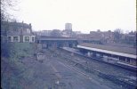
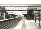
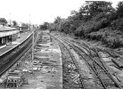
Found these images too. The first is from 1971 & I guess more or less taken from where the top of the flydown would be. Third one shows the former sidings - now the location of the flydown. The last two are both looking towards Lewisham, don't know the dates though.
Found these images too. The first is from 1971 & I guess more or less taken from where the top of the flydown would be. Third one shows the former sidings - now the location of the flydown. The last two are both looking towards Lewisham, don't know the dates though.
Attachments
Last edited:
Mikey C
Established Member
- Joined
- 11 Feb 2013
- Messages
- 6,869
The whole layout of the area, including Lewisham station itself is a mess. In an ideal world we'd bulldoze a square mile of that whole area and spend a year rebuilding itView attachment 114919
Yellow - Victoria (via Nunhead)
Purple - Charing Cross Mainline (Lewisham avoiding)
Green - Cannon Street
Orange - Charing Cross Metro
You can see why Lewisham Junction is so trublesome. Must be a total nightmare for PWay
Thanks for the photos and link; most interesting. Even got a glimpse or two of my old school!Found some relative stuff online - nice article on St Johns Station, with maps and images.
Found these images too. The first is from 1971 & I guess more or less taken from where the top of the flydown would be. Third one shows the former sidings - now the location of the flydown. The last two are both looking towards Lewisham, don't know the dates though.
- Status
- Not open for further replies.