Even in modern 5-screen banks there are places where lines are broken into sections above and below the main line of route. It depends on the structure of the line, the width of the main route at different points and the ease of operating it from a signaller's POV. No point in making them lean/scroll for a distant control when it could be quite neatly placed just to the left of where their attention is 90% of the time. (And sometimes to fit the workstation's area within 5 screens, which is considered the maximum comfortable to watch that won't give you a sore neck)I have idly wondered if that might be an artefact of when those sorts of systems were first becoming common (I'm assuming in the 80s when IECCs became a thing) that the cost of monitors, especially widescreen monitors, would have been cost prohibitive if you hadn't tried to squeeze as much info into each display as possible. Equally having a bank of screens would have been harder as well what with them being CRTs as well! By the time that modern flat screen displays were (comparatively) cheap and common it would likely have been more expensive in reprogramming (and refamiliarization!) to change it to take advantage of it not being especially difficult to lay out three modern widescreen monitors (or even six) to avoid having a single line on multiple rows.
-
Our booking engine at tickets.railforums.co.uk (powered by TrainSplit) helps support the running of the forum with every ticket purchase! Find out more and ask any questions/give us feedback in this thread!
You are using an out of date browser. It may not display this or other websites correctly.
You should upgrade or use an alternative browser.
You should upgrade or use an alternative browser.
Live signalling diagrams
- Thread starter Inversnecky
- Start date
- Status
- Not open for further replies.
Sponsor Post - registered members do not see these adverts; click here to register, or click here to log in
R
RailUK Forums
Inversnecky
Member
I have idly wondered if that might be an artefact of when those sorts of systems were first becoming common (I'm assuming in the 80s when IECCs became a thing) that the cost of monitors, especially widescreen monitors, would have been cost prohibitive if you hadn't tried to squeeze as much info into each display as possible.
Seems logical: looking back to the prescreen days of the 1960s, you’d have a whole wall with the lines going across in the new modern boxes.
In the 70s/80s, the 4:3 aspect ratio monitor was the only option, so you had to have top to bottom strips to avoid wasting screen real estate.
Interesting to see the treatment of London Waterloo (Traksy is provided rotated as well as right way, purely to match the other two).
Every map has something the others don't.
OTT seems to indicate slips well; they are on SignalMaps, but not on Traksy.

Traksy is less clutterred and, based on above discussion, perhaps more accurate in terms of the track layout, with some S&C numbers too.

SignalMaps has more horizontal compression and a black background (a good or bad thing depending on your PoV).

Railcam is behind a paywall, so can't compare, but this was on their website:

(Traksy unrotated)

Last edited:
Steve Harris
Member
Remember that they have additional data from Freightmaster, none of their rivals have this.
Point 1. Any idea when dark mode will be available?
Point 2. You mention subscribers, what benefits do they have over non subscribers?
Point 3. At Potters Bar for example, some signals have a red circle - are they shunt signals?
Point 4. a)How come some signals are grey and others show red or green?
b) Is it possible to show other aspects too eg red, single yellow, double yellow, green?
c)Or is it the case that only controlled signals can show what aspect it is displaying?
Apologies for what sound like nit picking but I am curious to find out the answers please.
I'm sure takno will be along at some point to give you an accurate answer, but from my own observations...
3. I believe so (as they tally up with shunt signals on other live maps).
4. a)I believe they are automatic signals.
b) As for the aspect colour, I think I read somewhere that the data feed just says if a signal is on or off (danger or proceed). Which does tally up with my learning of binary all those years ago at school.
c) Yes.
Hopefully the above will answer your curiosity until takno can give you a full indepth answer. As mine are purely observational, as like you, I have taken an interest in train live mapping for some time. Shame it wasn't available 25 yrs ago, would of been fun when I used to track bash.
Remember that they have additional data from Freightmaster, none of their rivals have this.
...
Point 4. How come some signals are grey and others show red or green? Is it possible to show other aspects too eg red, single yellow, double yellow, green? Or is it the case that only controlled signals can show what aspect it is displaying?
Apologies for what sound like nit picking but I am curious to find out the answers please.
To answer point 4:
Many older types of interlocking don't report automatic aspect information back to the signaller/control system and as such cannot send it on to the data feeds.
In some cases it would be possible to guess the actual signal aspect based on other signals in sequence however the data feed only reports a binary red/not-red state.
Automatic signal aspects (and other indications: level crossings, ground frames, slots/releases, etc) are available in more modern interlockings and control systems, some manufacturers are much better than others in this regard.
Aictos
Established Member
- Joined
- 28 Apr 2009
- Messages
- 10,403
That actually answers the next question I had because on SimSig you have the option of only showing controlled signals as per real life or show automatic signals and their aspects.To answer point 4:
Many older types of interlocking don't report automatic aspect information back to the signaller/control system and as such cannot send it on to the data feeds.
In some cases it would be possible to guess the actual signal aspect based on other signals in sequence however the data feed only reports a binary red/not-red state.
Automatic signal aspects (and other indications: level crossings, ground frames, slots/releases, etc) are available in more modern interlockings and control systems, some manufacturers are much better than others in this regard.
So be interesting to see this in real life too.
I can't get Traksy to run on Internet Explorer on Windows 10 - just a rotating circle once you hit the 'Hide' button on the page above, but it does run on Microsoft Edge (a Chrome based engine) on W10As it should be, as everyone have their own preferences.
I've edited the OP to include all mentioned - that's five now - any more?
Is there a glitch with Traksy that prevents it working on a PC (or my Firefox browser)?
While I can see the diagrams on my phone, I just can't get rid of this dialogue box on my laptop.
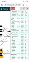
View attachment 94705
Also I can't see any routing highlighting on the Hertford North - Stevenage section, whereas is it is fine and nice and clear on OOT
There are a couple of TD areas where you get a bit more than just off/on, but these are few and far between.b) As for the aspect colour, I think I read somewhere that the data feed just says if a signal is on or off (danger or proceed). Which does tally up with my learning of binary all those years ago at school.
Some areas do have track circuit/section occupation, but not all. Some areas have it in its entirety (a lot of the newer Scottish non-IECC ones for example) whereas most have it just at more 'important' locations such as station termini.Do the data feeds allow track circuit occupation information? I notice some stations on signalmaps show if the track circuit in some platforms are occupied or not and I wonder if this would be a big step forward?
It is available in some areas, yes, but again it depends on age and system manufacturer. A few exceptional signalling areas have full track circuit information (Cambridge and Yoker come to mind), but most just have station platforms and certain loops or sidings.Do the data feeds allow track circuit occupation information? I notice some stations on signalmaps show if the track circuit in some platforms are occupied or not and I wonder if this would be a big step forward?
I've almost completed switching the membership and subscription system over to a new platform, and once that's complete I'll figure out some stuff like dark mode, but it's probably a little way down the track. Right now the only real benefit of getting a subscription is a warm feeling inside that you've helped pay for some of costs.Remember that they have additional data from Freightmaster, none of their rivals have this.
Point 1. Any idea when dark mode will be available?
Point 2. You mention subscribers, what benefits do they have over non subscribers?
Point 3. At Potters Bar for example, some signals have a red circle - are they shunt signals?
Point 4. How come some signals are grey and others show red or green? Is it possible to show other aspects too eg red, single yellow, double yellow, green? Or is it the case that only controlled signals can show what aspect it is displaying?
Apologies for what sound like nit picking but I am curious to find out the answers please.
As mentioned by others, unfilled circles are shunt signals.
Grey signals are ones where we don't have the data to show an aspect. The reason for that can vary from one area to another. In some areas for example, aspect information is provided for almost all signals, but in most it is only provided for non-automatic signals. In other areas (generally older panels) it isn't provided at all. Even where the data is provided, Network Rail don't make the mapping information freely-available, so oftentimes it's necessary to guess exactly what the data means. If we haven't done the guesswork then no signals get lit up red or green.
As others have indicated, you rarely get any information other than red/not red for signals, and accurately inferring yellow aspects is a pretty involved process.
Aictos
Established Member
- Joined
- 28 Apr 2009
- Messages
- 10,403
Ahh thanks for that, quite in-depth and answers my questions.I've almost completed switching the membership and subscription system over to a new platform, and once that's complete I'll figure out some stuff like dark mode, but it's probably a little way down the track. Right now the only real benefit of getting a subscription is a warm feeling inside that you've helped pay for some of costs.
As mentioned by others, unfilled circles are shunt signals.
Grey signals are ones where we don't have the data to show an aspect. The reason for that can vary from one area to another. In some areas for example, aspect information is provided for almost all signals, but in most it is only provided for non-automatic signals. In other areas (generally older panels) it isn't provided at all. Even where the data is provided, Network Rail don't make the mapping information freely-available, so oftentimes it's necessary to guess exactly what the data means. If we haven't done the guesswork then no signals get lit up red or green.
As others have indicated, you rarely get any information other than red/not red for signals, and accurately inferring yellow aspects is a pretty involved process.
Inversnecky
Member
I can't get Traksy to run on Internet Explorer on Windows 10 - just a rotating circle once you hit the 'Hide' button on the page above, but it does run on Microsoft Edge (a Chrome based engine) on W10
Also I can't see any routing highlighting on the Hertford North - Stevenage section, whereas is it is fine and nice and clear on OOT
After my earlier comments, I can get Traksy to work on Firefox on my PC as clicking hide on the dialogue box works, but I can't get rid of the doalogue box on Firefox on my laptop.
Steve Harris
Member
@takno Thank you for your in-depth and comprehensive reply ")
Traksy has that. Just click on a train and hit the "track train" button. It won't currently track a train from one map to another, but the Traksy maps are generally the largest of any of the sites, so hopefully that won't happen too often
I couldn't get this to work from my phone (latest Chrome on Android), as the pane that pops up with the train details doesn't seem to scroll quite far enough to see the last line with the buttons on it. It's the same if I select "desktop version" of the page. It works fine from Windows/Chrome though. I've attached an example, there should be another line for "Reading" and the buttons below that.
Attachments
Hmm. I thought I'd got all the cases of that. The easiest workaround is probably to add the app to your homescreen. That way it opens without the URL bar and the buttons should fitI couldn't get this to work from my phone (latest Chrome on Android), as the pane that pops up with the train details doesn't seem to scroll quite far enough to see the last line with the buttons on it. It's the same if I select "desktop version" of the page. It works fine from Windows/Chrome though. I've attached an example, there should be another line for "Reading" and the buttons below that.
Ok, that works.Thank you.Hmm. I thought I'd got all the cases of that. The easiest workaround is probably to add the app to your homescreen. That way it opens without the URL bar and the buttons should fit
BS56
Member
- Joined
- 6 Jan 2019
- Messages
- 124
I can never get signal maps to work on my computer it just say's Connecting with a black circle going round and round and that's all !
de525ma
Member
Are you using an ancient browser?I can never get signal maps to work on my computer it just say's Connecting with a black circle going round and round and that's all !
BS56
Member
- Joined
- 6 Jan 2019
- Messages
- 124
I might be this is the stuff for geeks.Are you using an ancient browser?
de525ma
Member
And browsing a forum about railways couldn't possibly be conceived as "for geeks"?I might be this is the stuff for geeks.
To keep yourself safe online it's in your interest to know what a web browser is, and which browser you are using. Easily Googled, five minutes of learning that may save yourself a considerable headache later on.
Anyway - download Google Chrome or Mozilla Firefox and use that to access signal maps and see if it works
Aictos
Established Member
- Joined
- 28 Apr 2009
- Messages
- 10,403
I've got a iPad running iOS 9 as it's so old and unable to be upgraded to a newer OS and as a result I can't view sites like Trsksy as the OS is the stumbling block not the bowser.And browsing a forum about railways couldn't possibly be conceived as "for geeks"?
To keep yourself safe online it's in your interest to know what a web browser is, and which browser you are using. Easily Googled, five minutes of learning that may save yourself a considerable headache later on.
Anyway - download Google Chrome or Mozilla Firefox and use that to access signal maps and see if it works
So maybe it's their OS at fault too?
Stathern Jc
Member
Also interesting to read comments on which formats people prefer.
Maybe an age thing but from the example screenprints Inversnecky posted (Thanks very much for that) I find some such as dark screens aren't so easy to get on with. It reminds me it must be getting near time I'm due for another eye test.
Makes me wonder if an optician might tell us there's something more than just personal preference.
signalmaps only supports modern browsers (Chrome/Firefox/Safari/Edge), internet explorer is not supported.I can never get signal maps to work on my computer it just say's Connecting with a black circle going round and round and that's all !
If you are already using a modern browser and it still does not work please use the contact link on the top-right of the site.
OTT remains my personal favourite (respecting that it's personal preference), though others are extremely useful as well. It covers a pretty wide area, has a clear layout with very easy to interpret route settings on most maps. The obvious weak point is the link to schedules, which is very haphazard, but usually resolved by clicking on a nearby station instead of the train.
The area coverage on Railcam is second to none, and headcodes usually display properly and click through to schedules correctly, with allocations if entered, but for me the layout of some maps is too crowded and there is the annual subscription cost. There is also only limited route setting information shown currently.
Signal Maps has the potential to be the best, but at the moment only covers quite a limited area. The detail in what it covers is excellent though (on most maps the best available), with distant/repeater signals showing yellow/green, flashing aspects, berth occupation and level crossing status (which OTT only has on a couple of its maps). Given the choice I prefer a black background, and the colour codes for how punctual the train is and a link to RealTimeTrains is a big plus. My major 'gripe' with it is that the route setting information is more difficult to interpret than the crisp clear green lines on OTT. If tracks where routes were set showed up in green, or white with other lines in grey, that would probably be enough for me to consider it the best.
Traksy is also perfectly reasonable, though that's the one I have the most problems with on a mobile device and the layout and colours isn't to my taste.
It's fantastic that these sites are available though for free - or at a modest price for Railcam, which obviously includes the live cams too. A huge thank you to all those who develop them for us to enjoy.
I wonder whether the recent widescale adoption of GPS based reports to back up automatic and TRUST/TOPS manual reports would make maps for areas where data feeds aren't available, a much more workable idea now?
If the GPS reporting was pushed into TRUST so that reports were delivered instantly through that platform I could get reasonable quality maps done fairly quickly for some areas. As it stands I have maps set up for Worcester, Paignton and the West Highland Line using the Trust reports, but it wasn't reliable enough to be worth pursuing to any great degrees.I wonder whether the recent widescale adoption of GPS based reports to back up automatic and TRUST/TOPS manual reports would make maps for areas where data feeds aren't available, a much more workable idea now?
As it stands I've got a feeling that the GPS data is scheduled to go into the National Rail feeds, which I'm not especially keen to start using. There are various interesting developments in the offing though using all the data, which might themselves to building maps of non-TD areas over the next couple of years.
Aictos
Established Member
- Joined
- 28 Apr 2009
- Messages
- 10,403
Talking of Open Train Times, it seems to be the industry default mapping website as most stations use it day in and day out.
With regards to Traksys, I like the fact that you can bring up one map and you can follow it from London Bridge all the way to Rainham in Kent without having to swap maps which is very useful.
I usually use three of the above at any one time but mostly Trsksy for work.
With regards to Traksys, I like the fact that you can bring up one map and you can follow it from London Bridge all the way to Rainham in Kent without having to swap maps which is very useful.
I usually use three of the above at any one time but mostly Trsksy for work.
If the GPS reporting was pushed into TRUST so that reports were delivered instantly through that platform I could get reasonable quality maps done fairly quickly for some areas. As it stands I have maps set up for Worcester, Paignton and the West Highland Line using the Trust reports, but it wasn't reliable enough to be worth pursuing to any great degrees.
As it stands I've got a feeling that the GPS data is scheduled to go into the National Rail feeds, which I'm not especially keen to start using. There are various interesting developments in the offing though using all the data, which might themselves to building maps of non-TD areas over the next couple of years.
The Windermere branch (which also has mass detector data and only one train at a time) and the Whitby branch (almost all services report at all stations) have stood out to me as candidates. Perhaps Whitby only after the Middlesbrough resignalling so as to connect the map to the 'outside world'.
Windermere might be a reasonable shout to at least show the train-in-branch. I think that works okay for ExmouthThe Windermere branch (which also has mass detector data and only one train at a time) and the Whitby branch (almost all services report at all stations) have stood out to me as candidates. Perhaps Whitby only after the Middlesbrough resignalling so as to connect the map to the 'outside world'.
- Status
- Not open for further replies.