Wow, you can always rely on Railforums to provide expertise in identifying stuff!
")
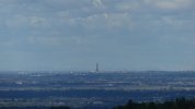
It is an impressive photo.
I was a little curious about how much zoomed in that picture is, so I did a couple of measurements:
I make it that the left hand edge of the visible big dipper ride that's visible in the photo is 520m West of a line joining Blackpool Tower to Liverpool Cathedral where the photo was taken. That big dipper is about 43.8 km away from Liverpool Cathedral, which means the portion of the photo between Blackpool Tower and the ride on its left covers an angle of just 0.68 degrees for the camera. That portion is a bit less than 1/5 of the width of the photo, so I make the entire photo to be about 3.3 degrees wide. (For comparison, if you look up at the moon in the night sky, the diameter of the moon covers an angle of about 0.5 degrees).
From Liverpool Cathedral, you certainly wouldn't be able to see the level of detail on the photo yourself with the naked eye (but you probably would if you were looking through binoculars).