• Our new ticketing site is now live! Using either this or the original site (both powered by TrainSplit) helps support the running of the forum with every ticket purchase! Find out more and ask any questions/give us feedback in this thread!

Rail journey GPS log

Status
Not open for further replies.

TGV

Member
Joined
25 Nov 2005
Messages
734
Location
320km/h Voie Libre
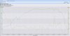
Has anyone here done this kind of thing (see image below).

It's a trace from a GPS data logger showing position overlaid on google maps with data taken every 5 seconds on location, speed, altitude etc...

The map speaks for itself, the red flag was the position of max speed (100.4mph) and the graph on the bottom right shows speed vs. time over the journey.

The device is very accurate - I've logged car journeys with it and it accurately shows detail down to what LANE on the motorway I was in!!! The speed is way more accurate than the speedo in the car and using a calculation for average speed it is approx 99.1% accurate to theoretical - good enough for my use. And according to OS maps the altitude is spot on - even if it's the one thing that occasionally shows an error, but that seems to be dependant on how many satellites are fixing your position.

Anyway, it works great on trains too - logged this journey tonight. Thought it might be interesting to some.
 

Attachments

  • WAT-BSK 13-09-10.jpg
    WAT-BSK 13-09-10.jpg
    178.2 KB · Views: 206
Sponsor Post - registered members do not see these adverts; click here to register, or click here to log in
R

RailUK Forums

TGV

Member
Joined
25 Nov 2005
Messages
734
Location
320km/h Voie Libre
Nice! What are you using for this?

It's a Mobile Action Technology GT100. About half the size of a box of matches. Built-in battery lasts approx 4 hours with fastest logging (every second) - up to 16 hours with longer intervals. I find 5 seconds is enough for rail journeys where direction changes are slow. That gives an 8 hour battery life roughly and decent resolution.

They cost about £50 to £60. Other manufacturers are available but quality varies - these GT100's are excellent and have the additional bonus of being water-resistant, so you can take them out in the rain. If you want to spend more, you can get racelogic units as used by race teams for about £400, but they're no more accurate - they are expensive because they can store much more data and log position, speed and altitude every 0.1 seconds!!! That's a lot of data.

The GT100, GT120 and GT200, like all the best ones to get have this chip in them:
http://en.wikipedia.org/wiki/SiRFstar_III

Check the spec. If it doesn't have one of these on board, it doesn't mean it's bad, but these SiRFstar III units have excellent reliability and sensitivity.

Also the software this thing comes with is great - you can export the data as a .csv file to excel or just plot it on the built-in google map system.
 

TGV

Member
Joined
25 Nov 2005
Messages
734
Location
320km/h Voie Libre
Is it one of these? http://www.frequencycast.co.uk/igotu.html

They come up when searching for GT100 GPS

The Mobile Action Technology website seems to be down for me at the moment.

Yup - that's the one. I'm glad you noted the M.A.T. website is down because I was trying to post a link to it, but couldn't!

It's a very slick bit of kit. Well made and the integration with the software is brilliant.

Note to Mac users - it's not supported on MacOS, so you'll have to boot-camp it or run on windows partition.
 

blackfive460

Member
Joined
23 Jun 2010
Messages
857
If you have a Windows Mobile smartphone with GPS you can do the same thinkg with Memory Map.
And having recorded a track you can export it into your favourite spreadsheet (just remember to convert the speeds from Knots!).
Of course, for those with an i(diot)Phone, there's an app for that...
 
Last edited:

ukrob

Established Member
Joined
15 Jan 2009
Messages
1,810
If you have a Windows Mobile smartphone with GPS you can do the same thinkg with Memory Map.
And having recorded a track you can export it into your favourite spreadsheet (just remember to convert the speeds from Knots!).

You can do it on many phones with many apps, but they won't be as good as a dedicated GPS.
 

asylumxl

Established Member
Joined
12 Feb 2009
Messages
4,260
Location
Hiding in your shadow
Or you can use a TomTom GPS device with various freely available applications. I have one that logs every second just like this device. A lot of GPS software logs every 5 seconds.
 

Peter Mugridge

Veteran Member
Joined
8 Apr 2010
Messages
16,088
Location
Epsom
I'm guessing you must have travelled in a 158 / 159 since the windows of Desiros block GPS signals?
 

Peter Mugridge

Veteran Member
Joined
8 Apr 2010
Messages
16,088
Location
Epsom
In that case this new device must be capable of working off much weaker signals than older ones. Interesting...
 

TGV

Member
Joined
25 Nov 2005
Messages
734
Location
320km/h Voie Libre
I'm guessing you must have travelled in a 158 / 159 since the windows of Desiros block GPS signals?

It was a class 444. Didn't get the number but it had a name plate "The Fab 444". Nice units - comfy and quiet - loads of leg room. Logged another one today to see if it was a fluke, but as you can see - it worked great (Woking to Basingstoke).

Yes - they are much more sensitive than a Tom Tom or Garmin type thing in my experience. They lock on to a signal well and quickly if stationary or moving slowly. Once it's locked in and logging, you can be doing 300mph and it'll still track you as long as it has some line of sight to the sky. I've used it in cars (works fine even sat in the cup-holder next to the gearstick!), on a boat, a plane and now a train. The only problem is if you try and start it logging while doing 100mph - it struggles to lock on, but that's all.

I think it'll be useful for logging any interesting journeys or particularly fast ones. Odd diversions etc... Not much use in tunnels - but it does take that into account - it'll begin logging position once out of the tunnel - the only thing is that it assumes a straight line in between, but the speed/time graph remains unaffected as it gets it's time stamp from the satellite.
 

Attachments

  • WOK-BSK 14-09-10.jpg
    WOK-BSK 14-09-10.jpg
    122.8 KB · Views: 38

Daimler

Member
Joined
5 Feb 2009
Messages
1,197
Location
Hertfordshire
I do a similar thing, using MyTracks, which is a free app on Android - it's pretty good too, though an appalling battery drain on the phone!
 

asylumxl

Established Member
Joined
12 Feb 2009
Messages
4,260
Location
Hiding in your shadow
Looks fantastic - would it work abroad - and at sea?


As far I'm aware, it's the "Global Positioning System". If it didn't work at sea, I'd be fearing for the lives of those on ships...

Yes - they are much more sensitive than a Tom Tom or Garmin type thing in my experience. They lock on to a signal well and quickly if stationary or moving slowly.

As far as I'm aware, that's because TomTom devices will not show a fix unless it has 4 satellites (for a 3d fix). Despite this, with 3 satellites, If you press the status bar on a TomTom device it will show you things such as signal strengths and longitude/latitude/elevation.
 
Last edited:

stuartmoss

Member
Joined
2 Feb 2010
Messages
1,017
Location
Leeds
The reason I asked was that some of the cheaper GPS devices are country specific and don't work internationally, I bought one that only has UK maps on it.
 

TGV

Member
Joined
25 Nov 2005
Messages
734
Location
320km/h Voie Libre
Yes it works anywhere on earth that has a GPS signal and will plot on a map anywhere that accepts KML to GPX data (google maps being the most commonly used).
 

ukrob

Established Member
Joined
15 Jan 2009
Messages
1,810
The reason I asked was that some of the cheaper GPS devices are country specific and don't work internationally, I bought one that only has UK maps on it.

I think you are possibly mixing up a GPS unit and a satnav (which contains a GPS chip).

This GPS device does not have a screen nor maps.
 

Peter Mugridge

Veteran Member
Joined
8 Apr 2010
Messages
16,088
Location
Epsom
Yes - they are much more sensitive than a Tom Tom or Garmin type thing in my experience.


Impressive; is there anything portable available with that sort of sensitivity that has a screen on it for a live speed display?
 

jimrbrobinson

Member
Joined
6 Jun 2010
Messages
257
Location
Astley, Tyldesley, Lancashire
I've had a Garmin eTrex for a couple of years now and it's ok but struggles in trees, etc. Also, I don't find the PC connection stuff all that user-friendly to be honest. This little unit certainly looks impressive for the price. The GT-100 are £44.99 at Maplin now, and I've just ordered one! :D Hopefully it'll come before my trip to Fort William on the 25th, and I'll be able to put it through its paces!
 

Peter Mugridge

Veteran Member
Joined
8 Apr 2010
Messages
16,088
Location
Epsom
Mine is a Garmin Foretrex 101; it works on everything except:

Desiros
Voyagers
334s ( but will work on 458s )
390s ( in the cabins; will work in the vesibules ).


I'd be interested in something similar in format and function to the 101 but with the sensitivity of the OP's device.
 

blackfive460

Member
Joined
23 Jun 2010
Messages
857
You can do it on many phones with many apps, but they won't be as good as a dedicated GPS.
That's not been my experience. This HTC Touch 2 with Memory Map software beats my previous Garmin unit hands down for accuracy and speed in getting a fix. I suppose it depends on the 'phone's hardware...
 

TGV

Member
Joined
25 Nov 2005
Messages
734
Location
320km/h Voie Libre
Impressive; is there anything portable available with that sort of sensitivity that has a screen on it for a live speed display?

Yes - a Holux GPSport 245. I've got one of those too. It has a LCD display that shows your LAT and LONG co-ords, and on another page you get your instant speed and max speed this trip.

Attached images from it and it's software. Class 159 journey from waterloo to Basingstoke, stopping at Woking. Also attached is a trace of an HST journey from Paddington to Reading - with all relevant specs on the top of the graphs.

Map attached too showing both routes (and the Reading - Basingstoke link too).

Incidentally - note that the 159 briefly exceeded it's stated max of 90mph (not a problem as the line limit is 100mph there anyway) and that the HST never quite got to 125mph but did cruise just below it for 8 or 9 minutes.
 

Attachments

  • WAT-BSK class 159.jpg
    WAT-BSK class 159.jpg
    60.1 KB · Views: 32
  • PAD-RDG 16-09-10.jpg
    PAD-RDG 16-09-10.jpg
    59.7 KB · Views: 29
  • WAT and PAD to BSK.jpg
    WAT and PAD to BSK.jpg
    184.4 KB · Views: 29
Last edited:

Daimler

Member
Joined
5 Feb 2009
Messages
1,197
Location
Hertfordshire
That's not been my experience. This HTC Touch 2 with Memory Map software beats my previous Garmin unit hands down for accuracy and speed in getting a fix. I suppose it depends on the 'phone's hardware...

Nor mine - my HTC with MyTracks is incredibly fast at locking onto satellites - faster than the Sony Ericsson W995 by a mile, comparable LG Phones and even the latest Garmin cycle-computer-satnav.
 

TGV

Member
Joined
25 Nov 2005
Messages
734
Location
320km/h Voie Libre
My Holux GPSport 245 has locked onto satellites as I'm sitting on my sofa typing this! It's picked them up through the window 12 feet away inside the house!

So yeah, it works fine on any train - Desiro's included. Traces from it are in post above.
 

Peter Mugridge

Veteran Member
Joined
8 Apr 2010
Messages
16,088
Location
Epsom
Just Googled it - looks good, but doesn't seem to have a strap?

And I am please to see it is available at Maplin - there is a Maplin 5 minutes walk from my office!:)


One more question - can it pick up the GPS in the cabin of a 390? It does get a bit tiring standing up in the vestibules for 2½ hour runs...
 

jimrbrobinson

Member
Joined
6 Jun 2010
Messages
257
Location
Astley, Tyldesley, Lancashire
Received today one Mobile Action GT-120 (i-gatU) from Maplin. Only tried it very briefly and not managed to do much maps-wise yet, but impressed with the accuracy. It got a reading from my bedroom windowsill and judging by where it placed the cross on Google Maps it was accurate to about 6 feet. Compared to the old Garmin eTrex which is lucky to even get within the right county under similar circumstances I'm impressed so far. The big test will be 25th Sept to 2nd Oct when I take on my trip to Fort William! :D

Package is the unit, a jelly sleeve, USB cable and 8cm driver cd. No straps included.
 
Status
Not open for further replies.

Top