• Our booking engine at tickets.railforums.co.uk (powered by TrainSplit) helps support the running of the forum with every ticket purchase! Find out more and ask any questions/give us feedback in this thread!

Tyneside 3rd rail

Status
Not open for further replies.

142094

Established Member
Joined
7 Nov 2009
Messages
8,789
Location
Newcastle
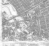
I don't think anyone has mentioned the Quayside Branch, rermarkable for two reasons: first that it followed a semi-circular route mostly in a tunnel from the sidings alongside the main line to the quay below and down-stream of Tyne Bridge, and second, it was electrified by overherad "Tram wire" and operated by that "Crocodile" loco they have in the mueum at York. I have seen that loco coupled to an 060 steam tank engine double-head a train off the quayside and into the tunnel. On another occasion a train of wagons, brake van to the fore, ran away down the tunnel, into the shunting yard at the bottom, and the brake van climbed vertically up a warehouse wall by the force of the train behind it! I have the newspaper cutting photograph still!

IIRC it was powered by overheads in Trafalgar yard and along the Quayside, with 3rd rail in the tunnel - plenty of stories where someone forgot to lower the pan and it hit the tunnel front...

Part of the line is still in use for the Tyne and Wear Metro, it is part of Stoddart Street sidings which are used to turn sets in the early morning.
 
Sponsor Post - registered members do not see these adverts; click here to register, or click here to log in
R

RailUK Forums

Anon Mouse

Established Member
Joined
20 Mar 2011
Messages
1,274
IIRC it was powered by overheads in Trafalgar yard and along the Quayside, with 3rd rail in the tunnel - plenty of stories where someone forgot to lower the pan and it hit the tunnel front...

Part of the line is still in use for the Tyne and Wear Metro, it is part of Stoddart Street sidings which are used to turn sets in the early morning.

I never knew that. Explains the victorian brick work pointing the wrong direction to the ECML (If that makes sense)
 

DaveNewcastle

Established Member
Joined
21 Dec 2007
Messages
7,387
Location
Newcastle (unless I'm out)
I don't think anyone has mentioned the Quayside Branch,

I attach a map from 1942 which clearly shows the route it took. The map also shows the 'Riverside Branch' a little further east.

You can see the Quayside Branch's curve crosses the Victoria Tunnel (under the ledgend "St Annes yard") and where it crosses, the Victoria tunnel was strengthened to sustain the weight of trains just a few feet above. The cutting between the two tunnel sections is largely unkempt open land, mainly public space and partly private; it has severe drainage problems associated with water flowing through the northern section of the tunnel. I'm told there is no access to either section of the tunnel.

I never knew that. Explains the victorian brick work pointing the wrong direction to the ECML (If that makes sense)
I think I know the arch you're referring to, it's on the north side of the western end of the bore under Shields Road West. It has puzzled me too, though I can't quite align it with the old Quayside Branch.

Another oddity is that the track on the Quayside has all been removed (as far as I can see), but there are short fragments left on the other side (the east side) of the Ouseburn, where the boat club berths it boats at the mouth of the Ouseburn. Apparently there was never any connection between the Quayside tracks on either side of the Ouseburn.
 

Attachments

  • Heaton and ouseburn 1942 - Lower Ouseburn.jpg
    Heaton and ouseburn 1942 - Lower Ouseburn.jpg
    419.9 KB · Views: 56
Last edited:

Anon Mouse

Established Member
Joined
20 Mar 2011
Messages
1,274
Thats a wonderful map, thanks for sharing. I suspect we are talking about the same arch too!
 

Anon Mouse

Established Member
Joined
20 Mar 2011
Messages
1,274
I must be thinking of a different arch - is there one near to Morrisons that I've missed?

seen from the metro between Stoddart Street and the start of the underground section on the RHS if you were travelling towards St. James. It points in the opposite direction as you would expect
 

DaveNewcastle

Established Member
Joined
21 Dec 2007
Messages
7,387
Location
Newcastle (unless I'm out)
I do think that's the same arch that I'm thinking of.
I walked past yesterday and it was clearly visible from the top of Stepney Lane, at the entrance to the tunnel under Shields Road West. I've found this on Google StreetView but the undergrowth almost obscures it - the arch in the very centre of this image.
http://maps.google.co.uk/maps?q=Newcastle+upon+Tyne&hl=en&ll=54.97403,-1.599584&spn=0.000025,0.018389&sll=54.978252,-1.61778&sspn=0.297511,0.588455&oq=newcastle&hnear=Newcastle+upon+Tyne,+Tyne+and+Wear,+United+Kingdom&t=m&z=16&layer=c&cbll=54.973958,-1.599786&panoid=D2qLxSiMIvgjJ2CJ_UrTKA&cbp=12,346.14,,0,5.88

Is that the same one, Anon?
 

Anon Mouse

Established Member
Joined
20 Mar 2011
Messages
1,274
I do think that's the same arch that I'm thinking of.
I walked past yesterday and it was clearly visible from the top of Stepney Lane, at the entrance to the tunnel under Shields Road West. I've found this on Google StreetView but the undergrowth almost obscures it - the arch in the very centre of this image.
http://maps.google.co.uk/maps?q=Newcastle+upon+Tyne&hl=en&ll=54.97403,-1.599584&spn=0.000025,0.018389&sll=54.978252,-1.61778&sspn=0.297511,0.588455&oq=newcastle&hnear=Newcastle+upon+Tyne,+Tyne+and+Wear,+United+Kingdom&t=m&z=16&layer=c&cbll=54.973958,-1.599786&panoid=D2qLxSiMIvgjJ2CJ_UrTKA&cbp=12,346.14,,0,5.88

Is that the same one, Anon?

Yes, thats the one! :)
 

John55

Member
Joined
24 Jun 2011
Messages
800
Location
South East
But by the same token, Eastern EPB's followed Southern EPB's.

The order in which BR built batches of rolling stock has no relevance to the choice of electric traction system.

And just to muddy the waters the LMS & LNER were using EP brakes long before BR changed the braking system for new trains in the early 50's.
 

yorksrob

Veteran Member
Joined
6 Aug 2009
Messages
39,044
Location
Yorks
The order in which BR built batches of rolling stock has no relevance to the choice of electric traction system.

And just to muddy the waters the LMS & LNER were using EP brakes long before BR changed the braking system for new trains in the early 50's.

The glorious EPB developed by a foreign region Sir !

Truely my world turned upsidedown :o
 

John55

Member
Joined
24 Jun 2011
Messages
800
Location
South East
The glorious EPB developed by a foreign region Sir !

Truely my world turned upsidedown :o

It is only a braking control system developed by Westinghouse and the other subsystem suppliers. As with most equipment for electric traction before WW2 it was of US origin.
 

yorksrob

Veteran Member
Joined
6 Aug 2009
Messages
39,044
Location
Yorks
Well, an EPB is more than just a braking system. It's also luxuriously padded seating, ample luggage provision, convenient access and egress and effective ventilation.
 

gimmea50anyday

Established Member
Joined
8 Jan 2013
Messages
3,456
Location
Back Cab
Wouldn't that have had a 42x class number though?

Under TOPS the 400 series numbers were allocated to southern region Direct Current electrical stock while the 500 series for other DC stock not based on the southern region. The current Tyneside units have been designated class 599 although they don't carry network rail fleet numbers. Following SR tradition the unit numbers should therefore start with a 9 as opposed to the 4 the do use
 

Peter Mugridge

Veteran Member
Joined
8 Apr 2010
Messages
14,830
Location
Epsom
Under TOPS the 400 series numbers were allocated to southern region Direct Current electrical stock while the 500 series for other DC stock not based on the southern region. The current Tyneside units have been designated class 599 although they don't carry network rail fleet numbers. Following SR tradition the unit numbers should therefore start with a 9 as opposed to the 4 the do use

I was referring to the proposed 6 car SR unit that was mentioned as a possible REP replacement in the post above mine.
 

gimmea50anyday

Established Member
Joined
8 Jan 2013
Messages
3,456
Location
Back Cab
Ah, my bad, misread. I assumed that replacement was for Tyne's EPB's!

I remember a ferry hill based traction inspector friend of mine many years ago telling me there were proposals to send metro trains down the leamside route as far as Belmont where the Durham park and ride is now, indeed proposals keep surfacing to extend at least as far as Washington. Given that the current south Hilton terminus route continues through to Chester le street and joins the leamside route north of houghton le spring one can only wonder what extent a north east metro could attain given ambitious expansion plans and perhaps a limitless funding pot to achieve it. Nissan alone would benefit hugely from such a network given its position alongside the leamside route and perhaps could serve Tyne dock by rail rather than by road as it does now. I have also wandered why the metro ends abruptly at st James and the tunnels never been extended to serve the west of the city in the fenham direction
 

142094

Established Member
Joined
7 Nov 2009
Messages
8,789
Location
Newcastle
Historcally the Metrocars were assigned the TOPS code 994, (with only the 4xxx number being displayed). No idea when or why it changed to 599.

Anon Mouse said:
seen from the metro between Stoddart Street and the start of the underground section on the RHS if you were travelling towards St. James. It points in the opposite direction as you would expect

That'll be the one I was thinking of, would have allowed access from the Quayside branch to Trafalgar Yard. Not sure what that arch is for, unless it was just part of the design for the tunnel mouth at the time. At the minute I think it is very rarely used as a headshunt, although I've only once seen anything use it (which was a Road-Rail Vehicle about 10 years ago). I've never paid much attention but it would be quite easy to add a length of line to access the ECML if it was ever needed for some reason.

gimmea50anyday said:
I have also wandered why the metro ends abruptly at st James and the tunnels never been extended to serve the west of the city in the fenham direction

Think the real reason for this is cost. The Metro was really quite fortunate to be built, as at the time there was a plan for extensions of the Central Motorway alongside investment in the new light rail system. The price of both construction projects ballooned, and then there was the Oil Crisis and subsequent recession, so less money for capital projects from central Government. Thankfully, it was the road schemes that were ditched and the money provided to finish off the Metro scheme. However, as part of that deal, the Tyne and Wear ITA and Tyne and Wear County Council were unable to access future funding for capital projects for a given time, and with the costs of tunnelling being so prohibitive, there wasn't much scope of the line being extended further west.
 

swt_passenger

Veteran Member
Joined
7 Apr 2010
Messages
31,443
That'll be the one I was thinking of, would have allowed access from the Quayside branch to Trafalgar Yard. Not sure what that arch is for, unless it was just part of the design for the tunnel mouth at the time. At the minute I think it is very rarely used as a headshunt, although I've only once seen anything use it (which was a Road-Rail Vehicle about 10 years ago).

I've looked into this area before, quite a few years ago now, and I think the concensus was that the tunnel portal was slightly further along, ie further towards Stoddart St, so there was a short open section just east of the skew bridges under the New Bridge St/Gibson St junction. I remember some sort of grassy mound to the left hand side of the up line from Tynemouth, so was that the actual portal? The road bridges are now very skewed so the original ECML underbridges may have been completely different to the steel girder version present now, which I think result from various road widening schemes subsequent to the railway. (Incidentally the ECML bridge was slab tracked for OHLE clearance during the ECML electrification - to touch on another recent subject!)

Google Earth's 1945 view of the site is not very clear at all, but at that time there seems to have still been some sort of goods depot (a transfer yard maybe?) on the site of the Stoddard St sidings - I don't remember seeing this in the sixties when I lived in the Heaton area though, is this what people are referring to as Trafalgar Yard, because I thought Trafalgar Goods was was on the down side just by the original Manors station, and was demolished when 'Manors North' opened in the early 1900s, and the goods traffic moved to the new goods depot which was opened at New Bridge St. (That being the big concrete shell that lasted into the 1980s.)

Does anyone know when the building I'm thinking of at the Metro sidings site would have been demolished?
 
Last edited:

sprinterguy

Established Member
Joined
4 Mar 2010
Messages
11,065
Location
Macclesfield
Historcally the Metrocars were assigned the TOPS code 994, (with only the 4xxx number being displayed). No idea when or why it changed to 599.
Are you sure that it has? I can find only one, online, reference to the class 599 classification. It doesn't seem to make any sense, when the final four digits of the class 994 numbers allow them to correspond nicely to the 40xx fleet numbers that the Metrocars already carry.
 

142094

Established Member
Joined
7 Nov 2009
Messages
8,789
Location
Newcastle
Are you sure that it has? I can find only one, online, reference to the class 599 classification. It doesn't seem to make any sense, when the final four digits of the class 994 numbers allow them to correspond nicely to the 40xx fleet numbers that the Metrocars already carry.

Internally they are now referred to as 599, although I haven't been able to find out why there has been a change.
 

142094

Established Member
Joined
7 Nov 2009
Messages
8,789
Location
Newcastle
I've looked into this area before, quite a few years ago now, and I think the concensus was that the tunnel portal was slightly further along, ie further towards Stoddart St, so there was a short open section just east of the skew bridges under the New Bridge St/Gibson St junction. I remember some sort of grassy mound to the left hand side of the up line from Tynemouth, so was that the actual portal? The road bridges are now very skewed so the original ECML underbridges may have been completely different to the steel girder version present now, which I think result from various road widening schemes subsequent to the railway. (Incidentally the ECML bridge was slab tracked for OHLE clearance during the ECML electrification - to touch on another recent subject!)

Google Earth's 1945 view of the site is not very clear at all, but at that time there seems to have still been some sort of goods depot (a transfer yard maybe?) on the site of the Stoddard St sidings - I don't remember seeing this in the sixties when I lived in the Heaton area though, is this what people are referring to as Trafalgar Yard, because I thought Trafalgar Goods was was on the down side just by the original Manors station, and was demolished when 'Manors North' opened in the early 1900s, and the goods traffic moved to the new goods depot which was opened at New Bridge St. (That being the big concrete shell that lasted into the 1980s.

Does anyone know when the building I'm thinking of at the Metro sidings site would have been demolished?

The portal was further along, to the east of Stoddart Street. Quite where I haven't yet found, but there is a ramp from Stoddard Street Sidings down to Stepney Road, and I'd say it probably started somewhere about there. As far as I can tell, Trafalgar Yard was just to the west of Gibson Street, not sure if the section between Gibson Street and Stoddart Street was grouped into this.
 

swt_passenger

Veteran Member
Joined
7 Apr 2010
Messages
31,443
Ah - I've now found some info, but I cannot provide a direct link and don't want to run into copyright problems, so try going here:

http://www.old-maps.co.uk/maps.html

Then, enter these coordinates in the boxes: 425700 and 564500

On the right hand side select one of the 1:2500 scale maps, I used the 1970 version (don't be put off by them being labelled 'Durham').

Should be right there now - and if you magnify the map you'll see that a road bridge has been removed since then, inline with the current Ingham Place, and the incline to the portal is shown just between there and just west of Stoddart St. This starts to ring a bell with me, as I do remember a relatively short stretch of visible track as the downhill gradient started. And the map markings possibly do suggest the 'grassy mound' that I mentioned earlier, do you think? The dotted lines of the tunnel curve then looks good to line up smoothly with the cutting further down (which is visible in as a tree covered area in current aerial views as well). I therefore think that the modern concrete walled incline between Metro tracks and sidings must be irrelevant to the branch?

Also, that building I was thinking of alongside the line is labelled as a factory, so probably not a goods depot, though possibly rail served.
 

142094

Established Member
Joined
7 Nov 2009
Messages
8,789
Location
Newcastle
The concrete retaining wall is modern, but must be at the same sort of level as what was there originally as the track at the tunnel mouth has stayed the same.
 

swt_passenger

Veteran Member
Joined
7 Apr 2010
Messages
31,443
But the track into the sidings doesn't follow the route of the tunnel, assuming the OS maps are reasonably accurate the tunnel would have been between the two present girder bridges, underneath the masonry section in the middle of this view:

http://goo.gl/maps/tvha3

In any case, the geometry is all wrong with respect to the curved part of the route that can be seen in the present day overhead views. To get from the south portal of the upper section of tunnel, to the end of the modern ramp, you'd need the route to take a straight line, with almost a 100 degree angle at the intersection with the ramp.

The line of the curve follows the greenery in the bottom centre of this shot:

http://goo.gl/maps/45E9S
 

142094

Established Member
Joined
7 Nov 2009
Messages
8,789
Location
Newcastle
Hmm I'll have a look tomorrow but I'm not sure if the line passed under Stoddart Street where you say underneath the masonry section.
 
Status
Not open for further replies.

Top