• Our booking engine at tickets.railforums.co.uk (powered by TrainSplit) helps support the running of the forum with every ticket purchase! Find out more and ask any questions/give us feedback in this thread!

Walking and Rambling discussion

Sponsor Post - registered members do not see these adverts; click here to register, or click here to log in
R

RailUK Forums

D6130

Established Member
Joined
12 Jan 2021
Messages
5,797
Location
West Yorkshire/Tuscany
While out hiking in rural East Sussex (one of my favourite areas in the entire world let alone the UK), I came across this...

View attachment 135645

A 16T mineral wagon in the middle of a rural field. There's never been any industry in this area. The field is about 3 miles from the Hastings Line & around 150m in height! Had to double take!
Is that location close to the Kent & East Sussex line in the Robertsbridge area? Perhaps the wagon originated from there, having been purchased by a local farmer for animal feed storage or something similar?
 

joncombe

Member
Joined
6 Nov 2016
Messages
769
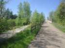
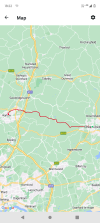
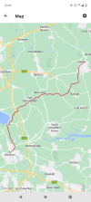
On Saturday I took the train to Wareham and then walked to Swanage. From the station I headed south into the pretty centre of Wareham and onwards to the bridge over the River Frome and crossed the river via the bridge then turned left along the Purbeck Way and Hardy Way alongside the river, with fine views back to the pretty quay.

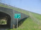
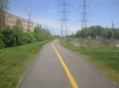
In about a mile I forked off left at the boat club into the village of Ridge which is indeed up a slight ridge. At the eastern side of the village I joined the Poole Harbour Trail to head south over Stoborough Heath on the old tramway. The first part had meadows with grazing horses alongside, later more open heathland. The Poole Harbour Trial forks off to the left at some point (I didn't notice where) but I continued on the old tramway to the A351. Crossing this I took the track ahead which turned out to be an exit road from the Blue Pool (a nearby tourist attraction). I continued on this until passing under the Swanage Railway and then turned right on a wooded bridleway down to the minor road and turned left through the hamlet of Furzebrook.

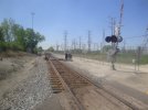
In about 1/4 of a mile I turned off on the Purbeck Way along the access road to the Blue Pool (this is also a footpath) and continued ahead past the entrance and into the open heathland, forking half right with the Purbeck Way. I continued on the Purbeck Way through some woodland and then along the bottom of the Purbeck Ridge towards Corfe Castle, soon reaching the beautiful castle and equally pretty village. I followed the path around the south side of the castle to the A351, turned left and then took the first right, going under the railway bridge (and hear saw a steam service waiting at Corfe Castle station) then immediately turned left up steps to East Hill (this is a permissive path, not marked on the map) for the steep climb up to the top of the Purbeck Ridge.

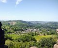
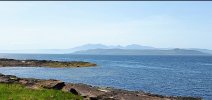
After the climb I was rewarded with wonderful views over the castle, village and station. I now followed the ridge-top path all along the ridge heading east towards Ulwell and Swanage. The views soon opened out on both sides with fine views over the rolling Purbeck Hills to my right and Poole Harbour to my left and soon the sea ahead. At Ulwell you have to drop down to cross the road then climbed back up to the obelisk and continued on the path along the top of the ridge until I reached the coast.

There are lovely views of Swanage Bay and the fine sandy beach here and I initially followed the coast path towards the town, now descending for the last time.As you near New Swanage I took a path to the left, down some slightly woobly steps to the beach since this is a much nicer walk than the coast path (which goes on a meander around a housing estate) when the tide is out, which it was. Soon I was able to join the promenade and continued to the Mowlem Theatre on the sea front. Swanage was busy with many taking advantage of the fine weather.

I then headed inland to Swanage station and arrived in time to take the last train of the day back to Wareham as this service runs on a Sunday. A very pleasant run back on the Class 117. We passed a steam service at Harmans Cross and another wait at Corfe Castle (the service isn't fast!). By the time we left Nordon for Wareham the train was pretty well loaded, which was good to see. We were held at the last signal before the main line to wait for a late-running west-bound SWR service then a brief run along the mainline (on what is normally the west-bound line) to Wareham arriving a couple of minutes late.

The SWR service seemed in a state of chaos with trains going west over an hour late, but fortunately for me I was going east and the trains in that direction were running on time.

A wonderful walk in one of my favourite areas and I was also very lucky with the weather which was mostly unbroken sunshine.

My photos from the walk : https://www.flickr.com/photos/joncombe/albums/72177720308496428
 

S&CLER

Member
Joined
11 Jan 2020
Messages
785
Location
southport
On successive Sundays I led 2 walks in the same area, with only partial overlap. I led the Walking Club's no. 2 walk from Hathersage up to the trig on Stanage Edge, then along to Upper Burbage bridge, down the bridleway to Lower Burbage bridge and by Padley Gorge to Grindleford, then back through woodland to Hathersage (9.2 miles). The following Sunday I led the Ramblers B walk from Hathersage via High Lees, Scraperlow and Mitchell Field, then across Hathersage Moor to the Toad's Mouth, then Padley Gorge again but this time crossing the gorge by the footbridge to walk the other, more difficult, side. From Grindleford station after a welcome ice cream break, we walked up Tedgness Road, through woods and back along the river to Hathersage (9.7 m). Both walks in excellent weather, with groups of just the right size (9 and 11).
 

Iskra

Established Member
Joined
11 Jun 2014
Messages
7,985
Location
West Riding
Today we did Snowdon up the miners track and then carried on to do the horseshoe taking in Y Llwedd too. Beautiful day for it and well worth it. (Pictures aren’t in chronological order and one is from the drive over)

IMG_1468.jpegIMG_1436.jpegIMG_1510.jpegIMG_1551.jpegIMG_1508.jpeg
 

railwalker

Member
Joined
11 Apr 2023
Messages
16
Location
skipton
Took the train to Leeds last week and then walked back home mainly along the Leeds to Liverpool canal (23.5 miles). What did surprise me was how quite (noise wise) the towpath was in Leeds.
 

Acey

Member
Joined
16 Nov 2018
Messages
257
The full Snowdon Horseshoe, over Crib Goch, Yr Wyddfa (Snowdon), Y Lliwedd may not be anywhere near the hardest walk in the UK but it's certainly one of the best.
Very true,done it several times,once when there was a total air inversion,was stunning ! Hardest walk I undertook was the Aonach Ridge ,pretty spectacular,weather was a bit iffy though !
 

Attachments

  • 40-Andy on ridge-85--112.jpg
    40-Andy on ridge-85--112.jpg
    127.1 KB · Views: 12
  • Untitled-Scanned-03.jpg
    Untitled-Scanned-03.jpg
    136.6 KB · Views: 12

32475

Member
Joined
2 Nov 2019
Messages
745
Location
Sandwich
Minehead to Bude. 174 miles and cumulative ascent of 23005ft. My son and I have just done a stretch of the South West Coast Path with a few add ons. Stunning weather. scenery, flora and fauna (75 bird species counted). Doing the walk was inspired by having read ‘The Salt Path’ by Raynor Wynn. Can’t wait to do the next leg to Land’s End next year!
B81619C9-1C65-4765-9CB5-73E497347B01.jpeg96A9318D-B45B-4370-A49F-59003699F72C.jpeg8F889122-0008-4ACF-98C9-49F72CDE853A.jpeg9EBDBCF3-E454-44BE-8F86-BB3D3ABC9A94.jpeg7D0D9B84-A5F1-4E33-AF3B-16B5B42DFD9A.jpeg
 

dangie

Established Member
Joined
4 May 2011
Messages
1,248
Location
Rugeley Staffordshire

32475

Member
Joined
2 Nov 2019
Messages
745
Location
Sandwich
I haven’t walked it but ‘500 Mile Walkies’ by Mark Wellington would inspire me to do it.
A great book which I must read again after many years. It is this book which inspired Raynor Wynn and her husband to walk the SWCP in the first place albeit under desperate personal circumstances.
 

Kite159

Veteran Member
Joined
27 Jan 2014
Messages
19,296
Location
West of Andover
Made the most of the weather yesterday to do a random walk from Pinhoe towards Topsham (via various mixed used paths and Sowton Industrial Estate) before heading towards Exeter along a path alongside the River Exe. Then to waste some time due to a train cancellation I headed towards the university via a mixed used path in woodlands.

Main walk was today with Pewsey to Hungerford walked on the Kennet & Avon canal, some very lovely Wiltshire countryside and woods (especially between Burbage & Bruce Tunnel). Towpath was very mixed in terms of condition, some areas it was quite narrow due to weeds. Sadly there was some work in the Crofton area forcing a detour on the roads, might need to revisit on another time when exploring the general Bedwyn area.

Just leaves Bath to Bristol along the Avon & Devizes to Pewsey which will probably be a job for a bus day (Salisbury to Pewsey, walk to Devizes then back to Salisbury depending what runs & times)
 

nlogax

Established Member
Joined
29 May 2011
Messages
5,378
Location
Mostly Glasgow-ish. Mostly.
Took the ferry from Largs and walked around Great Cumbrae island today. It's a ten mile loop, only did the northern side from the slipway to Fintry Bay and back again due to having the dogs along for the journey. Absolutely beautiful day with views right around the Firth of Clyde to Bute, Arran and down to Hunsterton. Bonus of (presumably) a RN submarine heading out from Faslane. Imagine I'll head back soon to do the full ten miles or some hiking in the middle of the island.
 

Attachments

  • Screenshot_20230529_195019_Photos.jpg
    Screenshot_20230529_195019_Photos.jpg
    477.7 KB · Views: 3
  • Screenshot_20230529_194911_Photos.jpg
    Screenshot_20230529_194911_Photos.jpg
    401.2 KB · Views: 3

THC

Member
Joined
21 Sep 2009
Messages
471
Location
Stuck on the GEML
Main walk was today with Pewsey to Hungerford walked on the Kennet & Avon canal, some very lovely Wiltshire countryside and woods (especially between Burbage & Bruce Tunnel). Towpath was very mixed in terms of condition, some areas it was quite narrow due to weeds. Sadly there was some work in the Crofton area forcing a detour on the roads, might need to revisit on another time when exploring the general Bedwyn area.
That diversion doesn't stray too far from the canal line and passes the entrance to the Crofton Beam Engines so it isn't entirely a wasted effort.

THC
 

railwalker

Member
Joined
11 Apr 2023
Messages
16
Location
skipton
Walk some of the Worth Way yesterday, stopping off at various points to watch/photograph the Flying Scotsman as it travelled the KWVR. An enjoyable walk made better by the FS.
 

Iskra

Established Member
Joined
11 Jun 2014
Messages
7,985
Location
West Riding
Walk some of the Worth Way yesterday, stopping off at various points to watch/photograph the Flying Scotsman as it travelled the KWVR. An enjoyable walk made better by the FS.
Very nice!

Today I walked some of the Monsal trail from Hassop to Millers Dale (and return). Stunning day for it :) This route must have been amazing to travel over by train.

765d23cd-8429-4c00-bbf6-db208038b8c2.jpegIMG_1624.jpegIMG_1665.jpegIMG_1647.jpeg
 
Last edited:

duncanp

Established Member
Joined
16 Aug 2012
Messages
4,856
I have just come back from the United States, where I spent some time walking in and around Chicago, St Louis and New York.

These photos are from the Illinois Prairie Path, a former railway line to the West of Chicago.
 

Attachments

  • Illinois Prairie Path (Ferry Road - Farnsworth Ave) - 2.JPG
    Illinois Prairie Path (Ferry Road - Farnsworth Ave) - 2.JPG
    4.8 MB · Views: 13
  • Illinois Prairie Path (Ferry Road - Farnsworth Ave) - 6.JPG
    Illinois Prairie Path (Ferry Road - Farnsworth Ave) - 6.JPG
    4.6 MB · Views: 13
  • Illinois Prairie Path (Ferry Road - Farnsworth Ave) - 8.JPG
    Illinois Prairie Path (Ferry Road - Farnsworth Ave) - 8.JPG
    4.3 MB · Views: 14
  • Illinois Prairie Path (Ferry Road - Farnsworth Ave) - 9.JPG
    Illinois Prairie Path (Ferry Road - Farnsworth Ave) - 9.JPG
    4.7 MB · Views: 15
  • Illinois Prairie Path (Ferry Road - Farnsworth Ave) - 11.JPG
    Illinois Prairie Path (Ferry Road - Farnsworth Ave) - 11.JPG
    4.5 MB · Views: 14
  • Illinois Prairie Path (Ferry Road - Farnsworth Ave) - 12.JPG
    Illinois Prairie Path (Ferry Road - Farnsworth Ave) - 12.JPG
    4.4 MB · Views: 13
Last edited:

CaptainHaddock

Established Member
Joined
10 Feb 2011
Messages
2,217

Attachments

  • IMG_20230603_153400539~3.jpg
    IMG_20230603_153400539~3.jpg
    2.8 MB · Views: 10

apk55

Member
Joined
7 Jul 2011
Messages
439
Location
Altrincham
Seeing the pictures of Millers dale reminds me of the disaster that has struck me.
What started off as an ordinary Sunday walk for me with my local walking club from Wyedale to Chelmorton, Taddington, Priescliffe and Millerdale - about 10miles and 1500 feet of climbing - ended in disaster when my leg suddenly collapsed with what was later diagnosed as a ruptured quadriceps tendon ( the one that pulls the lower half of my right leg straight) while descending to Millers Dale via a very steep path.
Despite some help from some of my friends they were unable to get me down as my leg was completely folded back so they called for help and got the local (Buxton) mountain rescue. Part of the group walked on while others stayed with me - some of those that walked on then drove drove back to the nearby Millers dale car park to pick up those who stayed with me. The mountain rescue team had considerable difficulty in getting me down in their all terrain stretcher to the Monsal trail as the way was very steep and blocked by fallen trees. I was then transferred to an ambulance and taken to Stepping Hill hospital in Stockport where I was operated on the following day. Now 11 weeks later I am slowly getting moving again - I can just about walk a mile slowly and on the level. And for a person who normally went walking several time a week this is very hard.

Anyway many thanks to the Mountain rescue organization
 

Iskra

Established Member
Joined
11 Jun 2014
Messages
7,985
Location
West Riding
Great photos! I've been out in Derbyshire today also, taking the new X17 bus from Sheffield to Wirksworth then climbing to the High Peak Trail to Middleton Top before dropping down to Cromford village for the bus home. An excellent day out!
Thank you! Ah, I'll be looking to use the very useful and excellent value X17 up to Wirksworth for the steam railway later this year. That sounds a great day, and what a beautiful day it has been for it :)
Seeing the pictures of Millers dale reminds me of the disaster that has struck me.
What started off as an ordinary Sunday walk for me with my local walking club from Wyedale to Chelmorton, Taddington, Priescliffe and Millerdale - about 10miles and 1500 feet of climbing - ended in disaster when my leg suddenly collapsed with what was later diagnosed as a ruptured quadriceps tendon ( the one that pulls the lower half of my right leg straight) while descending to Millers Dale via a very steep path.
Despite some help from some of my friends they were unable to get me down as my leg was completely folded back so they called for help and got the local (Buxton) mountain rescue. Part of the group walked on while others stayed with me - some of those that walked on then drove drove back to the nearby Millers dale car park to pick up those who stayed with me. The mountain rescue team had considerable difficulty in getting me down in their all terrain stretcher to the Monsal trail as the way was very steep and blocked by fallen trees. I was then transferred to an ambulance and taken to Stepping Hill hospital in Stockport where I was operated on the following day. Now 11 weeks later I am slowly getting moving again - I can just about walk a mile slowly and on the level. And for a person who normally went walking several time a week this is very hard.

Anyway many thanks to the Mountain rescue organization
I'm very sorry to hear about your accident and I'm glad you are somewhat recovering, I can only imagine the frustration and hope you can hit the hills again soon! The emergency services do a great job :)

I have just come back from the United States, where I spent some time walking in and around Chicago, St Louis and New York.

These photos are from the Illinois Prairie Path, a former railway line to the West of Chicago.
Interesting! I visited Chicago and New York last year. What's the railroad in your photo's?
 

duncanp

Established Member
Joined
16 Aug 2012
Messages
4,856
Thank you! Ah, I'll be looking to use the very useful and excellent value X17 up to Wirksworth for the steam railway later this year. That sounds a great day, and what a beautiful day it has been for it :)

I'm very sorry to hear about your accident and I'm glad you are somewhat recovering, I can only imagine the frustration and hope you can hit the hills again soon! The emergency services do a great job :)


Interesting! I visited Chicago and New York last year. What's the railroad in your photo's?

The railroad in my picture is a freight only line near Naperville, Illinois, where the Illinois Prairie Path is diverted from the trackbed of the old railway line before swinging Westwards towards Aurora.
 

THC

Member
Joined
21 Sep 2009
Messages
471
Location
Stuck on the GEML
Two consecutive days' walking near to my home:

Chelmsford to Harlow, 21 miles. Mid-Essex at her best on a fabulous day for a stroll. Out through Writtle College, Skreens Park and Shellow Bowells before refreshment stops at Matching Green and Churchgate Street saw me to Old Harlow and a woodland walk through Harlow Town Park to finish up in the town centre.

Wickford to Maldon, 15 miles. Another lovely day's walking in mid-Essex. My route took me through Runwell, South then East Hanningfield, before skirting Bicknacre and Purleigh. I then turned onto the old railway line to Maldon West station to finish with a pint in the Mighty Oak tap room before the bus home.

THC
 

Attachments

  • Screenshot_20230602-182207.png
    Screenshot_20230602-182207.png
    1.1 MB · Views: 9
  • Screenshot_20230603-154806.png
    Screenshot_20230603-154806.png
    732.4 KB · Views: 9

D6130

Established Member
Joined
12 Jan 2021
Messages
5,797
Location
West Yorkshire/Tuscany
Shellow Bowells
I just love the name of that village....and so does Bill Bryson, who mentioned it in his book "Notes from a Small Island" in the context of eccentric English place names. Personally, I think it well-describes an occasional affliction which I have suffered in the past after drinking too much real ale....especially the unfiltered variety! o_O
 

THC

Member
Joined
21 Sep 2009
Messages
471
Location
Stuck on the GEML
I just love the name of that village....and so does Bill Bryson, who mentioned it in his book "Notes from a Small Island" in the context of eccentric English place names. Personally, I think it well-describes an occasional affliction which I have suffered in the past after drinking too much real ale....especially the unfiltered variety! o_O
I've been there too! :oops::E

THC
 

Howardh

Established Member
Joined
17 May 2011
Messages
8,199
My knee's giving me kneeache so I'm stuck with flat walks - going up is no problem, but coming down is like having a dagger underneath my kneecap! So I'm sticking to canals for the time being. Never thought of a city walk alongside a canal, but being a fan of Above and Beyond (DJ's) I would like to follow the route they took in one of their videos where they were on a canal boat sailing along...

Trouble is, all I know is it's in north London. I know where it ends...near the Olympic Stadium. But this is the start...it's a long shot but can anyone place it? Looks like it's just after a lock (they did the whole hour without using locks); so here are three screenshots of fairly bland buildings which give little clue as to their location (to me...anyway!!).

Also, the nearest tube or train station would be handy...am I asking too much (yes I know this is more like geoguessr...) :p?
 

Attachments

  • Screenshot (75).jpg
    Screenshot (75).jpg
    174.8 KB · Views: 17
  • Screenshot (76).jpg
    Screenshot (76).jpg
    196.5 KB · Views: 17
  • Screenshot (77).jpg
    Screenshot (77).jpg
    145.4 KB · Views: 17

THC

Member
Joined
21 Sep 2009
Messages
471
Location
Stuck on the GEML
My knee's giving me kneeache so I'm stuck with flat walks - going up is no problem, but coming down is like having a dagger underneath my kneecap! So I'm sticking to canals for the time being. Never thought of a city walk alongside a canal, but being a fan of Above and Beyond (DJ's) I would like to follow the route they took in one of their videos where they were on a canal boat sailing along...

Trouble is, all I know is it's in north London. I know where it ends...near the Olympic Stadium. But this is the start...it's a long shot but can anyone place it? Looks like it's just after a lock (they did the whole hour without using locks); so here are three screenshots of fairly bland buildings which give little clue as to their location (to me...anyway!!).

Also, the nearest tube or train station would be handy...am I asking too much (yes I know this is more like geoguessr...) :p?
I'd say that's on the Regent's Canal - the nearest station would be Haggerston and those pics taken between there and York Way.

As an aside, the only time I ever fell asleep while raving was at an A&B set (Global Gathering 2010). Never been my thing. Thankfully Simon Patterson came on afterwards and woke me right up again. :oops::E

THC
 

S&CLER

Member
Joined
11 Jan 2020
Messages
785
Location
southport
On Sunday the Southport Ramblers A walk was a gruelling 10 miles with 2936 feet of ascent in hot sunshine from Glenridding up to Lanty's Tarn then up the north side of Grisedale to Grisedale Tarn, up St Sundays Crag and down to Glenridding via Birks. I managed to get as far as Grisedale Tarn and then decided to turn back and return on my own by the bridleway along the south side of Grisedale back to Patterdale and Glenridding, as after 17 days of radiotherapy I didn't feel up to the full walk - think I did pretty well in the circumstances for a 75 year old. Still sorry I missed out, but my health (prostate cancer treatment) comes first. The views were stupendous (loads of pics on the Southport Ramblers Facebook page). Last day of 20 days of radiotherapy tomorrow, after which I hope to get back to full fitness and lead a 9 mile walk at Eyam on 18 June.
 

Top