• Our booking engine at tickets.railforums.co.uk (powered by TrainSplit) helps support the running of the forum with every ticket purchase! Find out more and ask any questions/give us feedback in this thread!

Walking and Rambling discussion

Kite159

Veteran Member
Joined
27 Jan 2014
Messages
19,266
Location
West of Andover
A trio of walks this last weekend for me (although with a short time-wasting walk in Coalville in between buses)

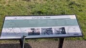
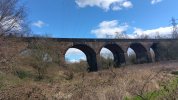
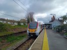
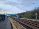
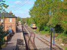
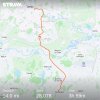
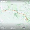
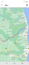
Saturday was Worthington* to Derby via the Cloud Trail, a walk of 3 parts. Route of the old Derby - Sinfin - Ashby railway route, then a section along the Trent & Mersey before the Derby Canal trail toward Pride Park [finishing off with a walk via the river to reach the station] (*quite a limited bus service on the Diamond route 125 Castle Donington - Leicester service with 2 buses each way)

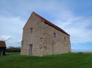
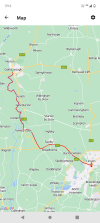
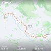
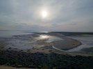
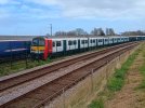
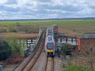
Sunday was the classic Monsal Trail old railway line from the bus stop at Topley Pike to Bakewell along a very busy path (and very pretty). Making use of the £2 bus fares and ability to do the walk on a Sunday [thankfully the weather turned out to be a beautiful day]

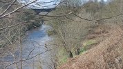
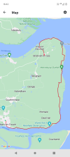
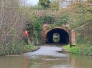
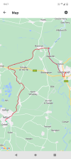
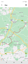
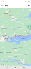
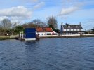
Today was a short section of the Leeds & Liverpool canal from Gargrave into Skipton, decent towpath quality with only one area of mud where the towpath is used as a farm track. Some beautiful views of the countryside, and I'm looking forward to doing Skipton to Shipley at some point (maybe June time)
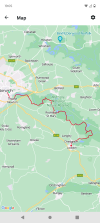
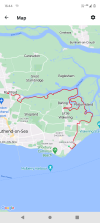
 

Attachments

  • Walk 18 March (Gargrave - Skipton).jpg
    Walk 18 March (Gargrave - Skipton).jpg
    431.7 KB · Views: 10
  • Walk 16 March (Worthington - Derby).jpg
    Walk 16 March (Worthington - Derby).jpg
    594.5 KB · Views: 10
  • Walk 17 March (Monsall Trail).jpg
    Walk 17 March (Monsall Trail).jpg
    471.6 KB · Views: 11
Sponsor Post - registered members do not see these adverts; click here to register, or click here to log in
R

RailUK Forums

THC

Member
Joined
21 Sep 2009
Messages
471
Location
Stuck on the GEML
Maldon to Tollesbury, 16 miles. A walk along the newly-minted England Coast Path with pit stops at Heybridge Basin and Goldhanger. Pubs plenty busy on this first day of spring. A walk bathed in sunshine.

THC
 

Attachments

  • IMG_20240320_103525711.jpg
    IMG_20240320_103525711.jpg
    4.7 MB · Views: 10
  • IMG_20240320_162516595_HDR.jpg
    IMG_20240320_162516595_HDR.jpg
    3.7 MB · Views: 9
  • IMG_20240320_181305981.jpg
    IMG_20240320_181305981.jpg
    3.3 MB · Views: 11
  • Screenshot_20240320-174519.png
    Screenshot_20240320-174519.png
    540.6 KB · Views: 12

THC

Member
Joined
21 Sep 2009
Messages
471
Location
Stuck on the GEML
Norwich to Great Yarmouth, 39 miles. The Wherryman's Way footpath, one of the excellent Norfolk Trails network, was my muse for a two day walk, starting in Norwich and following the river Wensum through Trowse and out into Broads country. A couple of decent pubs in the first ten miles was the only refreshment as the walk drifted out onto the marshes instead, the sugar beet factory at Cantley an ever-present among the twists and turns. Chedgrave then Loddon (23.3 miles) brought the first day to a close and an overnight stay in the Swan. Day two saw a retracing of steps back to the River Yare, albeit on the other bank, and then crossing to its north bank on the Reedham chain ferry. Reedham village with its swing bridge was the last settlement of any size before the final seven miles on the river, lots of windmills and the closed Berney Arms pub forming the only interludes as Yarmouth was reached just before the heavens opened. Good timing!

THC
 

Attachments

  • Screenshot_20240327-190556.png
    Screenshot_20240327-190556.png
    810.5 KB · Views: 12
  • Screenshot_20240328-135031.png
    Screenshot_20240328-135031.png
    822 KB · Views: 11
  • IMG_20240328_145721809.jpg
    IMG_20240328_145721809.jpg
    3.8 MB · Views: 12
  • IMG_20240328_130240145.jpg
    IMG_20240328_130240145.jpg
    4.6 MB · Views: 11
  • IMG_20240328_100743664.jpg
    IMG_20240328_100743664.jpg
    3.5 MB · Views: 11
  • IMG_20240328_093313505.jpg
    IMG_20240328_093313505.jpg
    4.8 MB · Views: 10
  • IMG_20240328_093035285.jpg
    IMG_20240328_093035285.jpg
    3.5 MB · Views: 11
  • IMG_20240327_102332979_HDR.jpg
    IMG_20240327_102332979_HDR.jpg
    3.9 MB · Views: 12

johnnychips

Established Member
Joined
19 Nov 2011
Messages
3,679
Location
Sheffield
Norwich to Great Yarmouth, 39 miles. The Wherryman's Way footpath, one of the excellent Norfolk Trails network, was my muse for a two day walk, starting in Norwich and following the river Wensum through Trowse and out into Broads country. A couple of decent pubs in the first ten miles was the only refreshment as the walk drifted out onto the marshes instead, the sugar beet factory at Cantley an ever-present among the twists and turns. Chedgrave then Loddon (23.3 miles) brought the first day to a close and an overnight stay in the Swan. Day two saw a retracing of steps back to the River Yare, albeit on the other bank, and then crossing to its north bank on the Reedham chain ferry. Reedham village with its swing bridge was the last settlement of any size before the final seven miles on the river, lots of windmills and the closed Berney Arms pub forming the only interludes as Yarmouth was reached just before the heavens opened. Good timing!

THC
Really impressed! Well done!
 

_toommm_

Established Member
Joined
8 Jul 2017
Messages
5,856
Location
Yorkshire
Norwich to Great Yarmouth, 39 miles. The Wherryman's Way footpath, one of the excellent Norfolk Trails network, was my muse for a two day walk, starting in Norwich and following the river Wensum through Trowse and out into Broads country. A couple of decent pubs in the first ten miles was the only refreshment as the walk drifted out onto the marshes instead, the sugar beet factory at Cantley an ever-present among the twists and turns. Chedgrave then Loddon (23.3 miles) brought the first day to a close and an overnight stay in the Swan. Day two saw a retracing of steps back to the River Yare, albeit on the other bank, and then crossing to its north bank on the Reedham chain ferry. Reedham village with its swing bridge was the last settlement of any size before the final seven miles on the river, lots of windmills and the closed Berney Arms pub forming the only interludes as Yarmouth was reached just before the heavens opened. Good timing!

THC

I don't suppose you've got a detailed version of that route anywhere please?
 

THC

Member
Joined
21 Sep 2009
Messages
471
Location
Stuck on the GEML
I don't suppose you've got a detailed version of that route anywhere please?
All but the first mile is marked on OS Explorer (1:25,000) map OL40 The Broads (you'll need the Norwich map for the first bit).

If you have the OS interactive app it's clearly marked thereon but if not the following resources may be useful:

LDWA: https://ldwa.org.uk/ldp/members/show_path.php?path_name=Wherryman's+Way

NCC: https://www.norfolk.gov.uk/article/42948/About-Wherrymans-Way

Shout if you need anything else.

THC
 

al78

Established Member
Joined
7 Jan 2013
Messages
2,425
IMG_20240327_124303877.jpg
A panorama of Llandudno and the Welsh coast from my walk up the Great Orme earlier this week.
 

_toommm_

Established Member
Joined
8 Jul 2017
Messages
5,856
Location
Yorkshire
All but the first mile is marked on OS Explorer (1:25,000) map OL40 The Broads (you'll need the Norwich map for the first bit).

If you have the OS interactive app it's clearly marked thereon but if not the following resources may be useful:

LDWA: https://ldwa.org.uk/ldp/members/show_path.php?path_name=Wherryman's+Way

NCC: https://www.norfolk.gov.uk/article/42948/About-Wherrymans-Way

Shout if you need anything else.

THC

Thanks so much :) I've found a GPX that I've imported into my route planner of choice (Komoot). That'll be one I'd love to do in one day in the summer.
 

THC

Member
Joined
21 Sep 2009
Messages
471
Location
Stuck on the GEML
Thanks so much :) I've found a GPX that I've imported into my route planner of choice (Komoot). That'll be one I'd love to do in one day in the summer.
My pleasure 8-) High summer would be your best bet to walk it in a day, I'd imagine. I wouldn't fancy being out on the broads after dark!

THC
 

apk55

Member
Joined
7 Jul 2011
Messages
439
Location
Altrincham
After my injury last year when a tendon in my knee ruptured (see earlier entries) I am slowly getting back walking again.
It took 6 months before I could mange easy walks with my walking club. Then I was tired after a 5 to 6 mile easy walk, now after another 6 months I have plenty left and hope to try some longer walks soon.
On Friday I went for a walk on my own from Eccles to Radcliff mostly along the old ELR Patricroft, Clifton Junction and Radcliff line. Starting from Eccles Metrolink stop and walking to Monton where the section of line has been converted into a walkway up to the mouth of the tunnel.. Then a bit of fun finding my way into the Irwell valley before rejoining the line which again has been converted to walkway (Outwood way) and finishing at Radcliff metrolink. It was about 9 miles in total.
 

Attachments

  • IMG_20240322_112440_HDR.jpg
    IMG_20240322_112440_HDR.jpg
    424.8 KB · Views: 10
  • IMG_20240329_112853_HDR.jpg
    IMG_20240329_112853_HDR.jpg
    381.9 KB · Views: 10
  • IMG_20240329_123550_HDR.jpg
    IMG_20240329_123550_HDR.jpg
    475.2 KB · Views: 6
  • IMG_20240329_124435_HDR.jpg
    IMG_20240329_124435_HDR.jpg
    370.6 KB · Views: 8

THC

Member
Joined
21 Sep 2009
Messages
471
Location
Stuck on the GEML
Shoeburyness to Rochford, 18 miles. Back onto the England Coast Path, first avoiding the MoD's strange buildings and firing ranges before reaching the pretty village of Great Wakering. Crossing Wakering Common, I left the intrepid explorers bound for the Broomway to gamble with the spring tides, turning north instead along Havengore Creek and up the edge of Potton Island to splendid isolation. Following various creeks and inlets around the edge of Birling and Little Wakering, I eventually left the coast path for a final mile up through historic Rochford to my train home.

THC

--


Burnham-on-Crouch to Bradwell-on-Sea, 19.6 miles. On this most isolated of recent walks along the England Coast Path, I headed out to sea before turning north to the seventh-century St Peter's Chapel and then, in sight of West Mersey, I passed Bradwell nuclear power station before heading inland for the last bus of the day off the Dengie peninsula. I saw barely another soul all day. Bliss.

THC
 

Attachments

  • IMG_20240330_100411742.jpg
    IMG_20240330_100411742.jpg
    4.2 MB · Views: 19
  • IMG_20240330_100516993.jpg
    IMG_20240330_100516993.jpg
    4.4 MB · Views: 11
  • IMG_20240330_163632581_HDR.jpg
    IMG_20240330_163632581_HDR.jpg
    3.8 MB · Views: 14
  • Screenshot_20240330-164403.png
    Screenshot_20240330-164403.png
    555.8 KB · Views: 15
  • IMG_20240402_092116082.jpg
    IMG_20240402_092116082.jpg
    4.5 MB · Views: 4
  • IMG_20240402_143410114.jpg
    IMG_20240402_143410114.jpg
    4.5 MB · Views: 5
  • IMG_20240402_163451627_HDR.jpg
    IMG_20240402_163451627_HDR.jpg
    5.7 MB · Views: 7
  • Screenshot_20240402-164202.png
    Screenshot_20240402-164202.png
    499.2 KB · Views: 8
Last edited:

Kite159

Veteran Member
Joined
27 Jan 2014
Messages
19,266
Location
West of Andover
Yesterday I walked another section of the Grand Union canal starting from Aylesbury towards the junction with the main canal (Marsworth Junction) for a short section along the main canal to head on the Wendover arm. Aylesbury arm was a towpath of two complete contrasts, the first ~ 4 miles was on solid ground (a few areas of puddles from recent rain) before suddenly turning rural and extremely muddy. Certainly not a canal arm I would recommend doing this time of year, unless you like thick mud. Wendover arm was a strange experience, with parts being restored with a decent towpath (and some beautiful woodlands), some parts being restored in progress with a short area requiring a detour near Tringford. Some beautiful views of the countryside with stations at both ends (although I did use a couple of buses from Reading to Aylesbury via High Wycombe to lower the cost)

Today was back to disused railway walks with the Meon Valley Trail from West Meon (served by the infrequent 67 bus between Winchester & Petersfield) towards Wickham (served by the hourly 69 bus between Winchester & Fareham plus a handful of services with a First Solent route 20). A beautiful countryside walk with good views and being peaceful, but again the path was suffering from all the recent rain and was muddy in places. Strange in terms of busy sections as other people seemed to come in lumps, busy at the Wickham end near the car park but once onto the dead-end bridleway leading to the former junction (which seems to have been reopened) it was quiet.

Better weather on the day than what was forecasted at the start of the week when both days were predicted to be wash-outs.

----

THC, that walk in Burnham-on-Crouch looked interesting, reminds me when I did the walk from North Fambridge towards Burnham-on-Crouch along the riverfront at how peaceful it was
 

THC

Member
Joined
21 Sep 2009
Messages
471
Location
Stuck on the GEML
Retford to Lincoln, 47 miles. This two-day walk took in three contrasting waterways in roughly equal measure, firstly the lower Chesterfield Canal from Retford through remote north Nottinghamshire to the River Trent, then south along the tidal Trent, overnighting at Gainsborough across the bridge in Lincolnshire (22 miles), before on day 2 resuming along the Trent to Torksey before crossing onto the Fossdyke Navigation - built by the Romans in 120AD - to carry me into Lincoln. The 3-mile trudge along the A57 either side of Saxilby (no towpath here) did not dampen my spirits as the final few miles into Lincoln more than made up for it. A grand entrance to a lovely city was completed by a march up Steep Hill to Lincoln Cathedral, before rolling down again and onto the station for my train home.

THC
 

Attachments

  • IMG_20240405_112217532.jpg
    IMG_20240405_112217532.jpg
    5.1 MB · Views: 10
  • IMG_20240405_145931035.jpg
    IMG_20240405_145931035.jpg
    3.2 MB · Views: 10
  • IMG_20240405_192349740_HDR.jpg
    IMG_20240405_192349740_HDR.jpg
    4.1 MB · Views: 10
  • Screenshot_20240405-192755.png
    Screenshot_20240405-192755.png
    588.5 KB · Views: 7
  • IMG_20240406_072132317_HDR.jpg
    IMG_20240406_072132317_HDR.jpg
    3.8 MB · Views: 7
  • IMG_20240406_164617180.jpg
    IMG_20240406_164617180.jpg
    4.9 MB · Views: 6
  • IMG_20240406_174011223.jpg
    IMG_20240406_174011223.jpg
    3.9 MB · Views: 6
  • Screenshot_20240406-171230.png
    Screenshot_20240406-171230.png
    783.9 KB · Views: 7

Kite159

Veteran Member
Joined
27 Jan 2014
Messages
19,266
Location
West of Andover
Hope the towpaths weren't too bad for you, especially on the Trent after all the rain in the last few months.
 

THC

Member
Joined
21 Sep 2009
Messages
471
Location
Stuck on the GEML
Hope the towpaths weren't too bad for you, especially on the Trent after all the rain in the last few months.
No problems at all, I'm pleased to say. :E

Kite159 said:
THC, that walk in Burnham-on-Crouch looked interesting, reminds me when I did the walk from North Fambridge towards Burnham-on-Crouch along the riverfront at how peaceful it was

If it's a still day then it is blissfully peaceful thereabouts.

This is the best time of year to walk the coast in Essex as the paths will soon become overgrown and practically impassable in places. I've a couple more day walks to fit in on that stretch before that happens for this year.

THC
 

Iskra

Established Member
Joined
11 Jun 2014
Messages
7,946
Location
West Riding
Bleaklow air crash sites

Today, I did the hike up from Snake Pass Summit in the Dark Peaks, to Higher Shelf Stones where good views of the Manchester cityscape are available, before heading to the nearby crash site of an American B29 bomber where a significant amount of wreckage is still visible. We then headed to Bleaklow summit and then onto the crash site of a RAF Blenheim bomber which is quite difficult to find and in very challenging terrain. It started off dry and pleasant until we reached the summit of Bleaklow where heavy rain and strong winds started, which flooded the already saturated ground, making it difficult and very wet from then on in and we were soaked to the bone by the time we returned to the car. It was forecast, but we were unable to start the walk any earlier due to prior commitments the evening before. Luckily, I had the foresight to pack changes of clothes in the car so at least we could get dry and warm for the journey home. A nice first proper hike of the year, just to get us back into the swing of things, with a bit of added historical interest and some nice nature viewed too. The poor weather at the end of the walk certainly made in an invigorating experience.

thumbnail_IMG_4607.jpgthumbnail_IMG_4616.jpg
 

THC

Member
Joined
21 Sep 2009
Messages
471
Location
Stuck on the GEML
Ongar to Chigwell, 15.7 miles. Bookended by two former Great Eastern Railway stations that have passed into new ownership, this stretch of the Three Forests Way took me south east from Ongar through some quite remote countryside either side of the M25 on the north eastern fringe of Greater London without ever quite getting there. I finished at Chigwell, the last bastion of Essex hereabouts, where I took the Central line to Woodford to begin my journey home.

THC
 

Attachments

  • IMG_20240418_100026873.jpg
    IMG_20240418_100026873.jpg
    3.8 MB · Views: 9
  • IMG_20240418_112535024.jpg
    IMG_20240418_112535024.jpg
    3.1 MB · Views: 6
  • IMG_20240418_160157221.jpg
    IMG_20240418_160157221.jpg
    5.3 MB · Views: 8
  • Screenshot_20240418-160346.png
    Screenshot_20240418-160346.png
    847 KB · Views: 8

ChrisC

Established Member
Joined
7 Oct 2018
Messages
1,615
Location
Nottinghamshire
I’ve done a couple of walks in two very contrasting areas of Derbyshire during the last week.The first walk was in an ex industrial area near Ilkeston and the the second walk just outside the Peak District National Park near Matlock.

My first walk of about 9 miles began at Shipley Country Park just outside Heanor. The walk began inside the country park and then continued down the Nutbrook Trail to the Erewash Canal at Stanton Lock, then north along the canal towpath into Ilkeston. Shipley Country Park is a huge park of around 700 acres and claims to have around 20 miles of footpaths within the park. I can believe that because I have done numerous walks and cycle rides around the park and there are always new paths to discover. This time I walked fairly directly north to south through the park to access the Nutbrook Trail which runs south from the park for 10 miles to Long Eaton and the River Trent.

On leaving Shipley Park the trail skirts around the western edge of Ilkeston passing through nature reserves and heathland, woodland and by the side of lakes. It’s hard to believe now that part of the route actually is over the site of the old Shipley Colliery and close to the site of the long gone American Adventure Theme Park. After passing a very pleasant lakeside at Straws Bridge the train continues along the route of the old Stanton Railway Branch. This then passes the huge site of the Old Stanton Ironworks which is currently being redeveloped. From here the trail joins the towpath of the Erewash Canal down through Sandiacre and Long Eaton to the River Trent at Kent Lock.

Having parked my car at Shipley Park I left the Nutbrook Trail at Stanton Lock and headed north along the Canal towpath up towards Ilkeston to get the Trent Barton 34 bus back to Shipley Park. As I left the canal in Ilkeston to reach the bus stop I did a slight detour to along the short street by the canal aptly called Canal Street. My grandmother was born in one of the red brick terraced houses and lived along with her parents and 5 sisters and 2 brothers from when she was born in the year 1910 until she married my grandfather in the early 1930’s. All well before my time!

IMG_6546.jpegIMG_6248.jpeg
IMG_6253.jpeg

My second walk was just to the south of Matlock in the Derwent Valley, following the Cromford Canal south from Cromford Meadows to Ambergate.
This is was a walk of only just under 6 miles but it took me well almost 3 hours because there was so much to stop and look at of interest in the way. Also despite the very cold wind, down in the valley in the sun it was quite warm and being such a peaceful location with lovely views I did stop a couple of times just to sit in a seat and enjoy it. It’s only just under 25 miles away from where I live but I’ve not done this walk for well over 40 years. It hasn’t changed that much from what I remember, but if anything it has been tidied up and is more picturesque than I remembered.

The Derby to Matlock rail line runs parallel with this walk with stations at both Cromford and Ambegate plus the Derby to Buxton TransPeak bus also follows the same route down the Dervent Valley. At one point between the Whatstandwell and Ambergate it is easy to see how the railway, canal, main A6 road and the River Derwent all run side by side through the valley. When I reached Ambergate I caught the bus up to Matlock Bath where I joined hundreds of motorcyclists who gather there every weekend when the weather is good. The fish and chips were very good.

IMG_6559.jpegIMG_6555.jpegIMG_6558.jpeg
IMG_6570.jpeg
 

Top