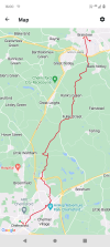
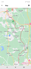
This evening I've been looking at the disused railway walks from Hindlow towards Cromford & Tissington/Ashbourne, not the easiest to do as at a glance Pomeroy at the northern end has one bus per day Monday - Saturday and 2 buses a day on a Sunday. Unless it gets more buses during the summer months, otherwise it seems it's a 2 mile walk from Earl Sterndale
Also seems to be a difference between Google maps and the bus times website regarding the daily 441 bus from Buxton to Ashbourne. Google suggests it calls at Parsley Hay (the junction where the line to Cromford heads away) but bus times suggests it skips that village.
----
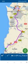
Anyhow Saturday (2nd March) my original idea was to head towards Cheddar to walk the old railway route towards Yatton (maybe with a circle of Cheddar reservoir as it seems to have a path which goes all the way round). All set up with bag packed, checked the weather this morning when I woke up to find it had changed to heavy rain until 2pm. (Met Office) so decided not to risk getting soaked and ended up in Chard (well it was Somerset lol)


")