• Our booking engine at tickets.railforums.co.uk (powered by TrainSplit) helps support the running of the forum with every ticket purchase! Find out more and ask any questions/give us feedback in this thread!

Walking and Rambling discussion

THC

Member
Joined
21 Sep 2009
Messages
473
Location
Stuck on the GEML
.

Does the towpath remain as tarmac throughout? Next section might be Croy towards Polmont maybe extending to Linlithgow
It didn't when I walked it eight years ago but that might have changed in the meantime. It's perfectly passable though throughout.

THC
 
Sponsor Post - registered members do not see these adverts; click here to register, or click here to log in
R

RailUK Forums

Techniquest

Veteran Member
Joined
19 Jun 2005
Messages
21,674
Location
Nowhere Heath
I've finally decided to start following this thread! It's taken me long enough, and some rather interesting walks have been done just from the last couple of pages I've read.

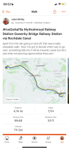
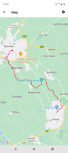
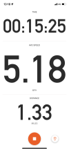
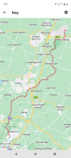
My last walk that wasn't a commute/positioning to/from my local station was Luton Airport Parkway station to Luton Airport's DART station. A nice bit of new coverage there, in 15 and a bit minutes. Considering it was uphill, and the pace dropped significantly after cresting the top of Airport Way, due to the amount of slow movers on the narrow pavement, I don't think that was too bad :D 
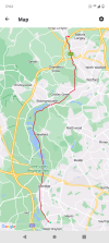
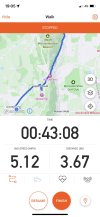
I've attached a screenshot from the point I got to the main entrance, the DART terminal being slightly further on.

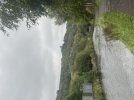
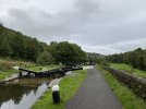
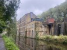
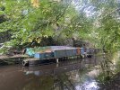
The previous walking expedition was in Aylesbury, not a place I'm rushing to go back to! I've done power-walks in Bristol in recent weeks too, one of which was Cribbs Causeway Bus Station to Bristol Parkway station. I've done a lot of walks this year, as is often the case, and one from recent weeks that would be of interest to some on here was the walk I did from Five Ways' tram stop to Kings Norton station along the Worcester & Birmingham Canal.

That was just short of 6 miles I seem to recall, and my goal is to complete my walking coverage of that canal all the way to Worcester city centre. There's a long way to go yet, but I suspect I could do it in either one massive session or two more sensibly sized trips.

I've been running quite a bit recently, otherwise I'd have even more walking adventures to share. Photos attached are a very, very small sample of some of this year's walks. I honestly have too many interesting ones to discuss here.

Photos in order:

1) Strava screenshot from the walk to Luton Airport last week
2) Earlier this summer, a bucket-list walk from Great Malvern to Colwall screenshot from Strava
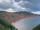
3) Red cliffs of Devon near Haven Devon Cliffs
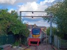
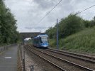
4) Midland Metro tram taken from the shared-use path alongside the tram line, just west of The Hawthorns
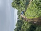
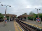
5) A view of Lympstone Village station
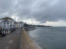
6) Exmouth seafront, on the same walk as the one taking on Lympstone, check out the difference in weather!
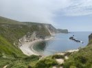
7) A view from the South West Coast Path a bit west of Durdle Door
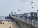
8) Bournemouth Pier
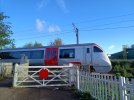
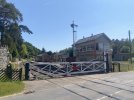
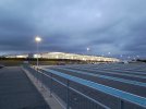
9) Parkend station, Dean Forest Railway

That'll give you all an idea of how varied my year's been so far, and that's just a small sample of my walks. You should see where I've been running and cycling!
 

Attachments

  • 35C0B177-893B-4895-8142-F6CF64C6C4F3.jpeg
    35C0B177-893B-4895-8142-F6CF64C6C4F3.jpeg
    204 KB · Views: 5
  • BF1D3B9D-6139-4B67-84DA-E890B2F05FFF.jpeg
    BF1D3B9D-6139-4B67-84DA-E890B2F05FFF.jpeg
    2 MB · Views: 4
  • CEFD1BA6-A6AF-40D1-B894-0F0CB1360377.jpeg
    CEFD1BA6-A6AF-40D1-B894-0F0CB1360377.jpeg
    2.8 MB · Views: 6
  • C69902FA-4589-4DC4-93B5-086C9B88B5E3.jpeg
    C69902FA-4589-4DC4-93B5-086C9B88B5E3.jpeg
    2.8 MB · Views: 6
  • FE74678A-966A-4193-8873-D8F1A63A0BCB.jpeg
    FE74678A-966A-4193-8873-D8F1A63A0BCB.jpeg
    2.4 MB · Views: 6
  • 3B23F2CA-5CB8-4AAF-96A4-7A1AB3749DEF.jpeg
    3B23F2CA-5CB8-4AAF-96A4-7A1AB3749DEF.jpeg
    3.3 MB · Views: 5
  • 5D546ACD-11AB-40FB-82FE-C370D27D7EC9.jpeg
    5D546ACD-11AB-40FB-82FE-C370D27D7EC9.jpeg
    1.8 MB · Views: 5
  • 442E680F-A3F4-4888-B8A7-08CE947F7082.jpeg
    442E680F-A3F4-4888-B8A7-08CE947F7082.jpeg
    3.6 MB · Views: 6
  • 0A766B63-635B-40B5-82A3-96B1586D415F.png
    0A766B63-635B-40B5-82A3-96B1586D415F.png
    123.9 KB · Views: 6

THC

Member
Joined
21 Sep 2009
Messages
473
Location
Stuck on the GEML
Loughton to Stansted Airport, 29.3 miles. I followed the Forest Way footpath for the first 25 or so through Epping Forest and around Harlow to Hatfield Forest, then some Flitch Way along the old Stortford to Braintree branch trackbed, then round Takeley and to the airport bus station just before dark.

THC
 

Attachments

  • IMG_20231001_085747642.jpg
    IMG_20231001_085747642.jpg
    3.7 MB · Views: 11
  • IMG_20231001_092722169.jpg
    IMG_20231001_092722169.jpg
    2.7 MB · Views: 10
  • IMG_20231001_185023879.jpg
    IMG_20231001_185023879.jpg
    3.6 MB · Views: 11
  • Screenshot_20231001-190140.png
    Screenshot_20231001-190140.png
    900.1 KB · Views: 11

Techniquest

Veteran Member
Joined
19 Jun 2005
Messages
21,674
Location
Nowhere Heath
Very impressive!

Today I did Mytholmroyd to Sowerby Bridge along the Rochdale Canal, that was really nice :D I'm absolutely going to have to return to finish the job all the way into Manchester at some point!

Attached are some photos from the walk, from station to station it came in at 4.7 miles all in :)
 

Attachments

  • 896E1957-27EA-4180-9EB8-2173D83CC9A4.jpeg
    896E1957-27EA-4180-9EB8-2173D83CC9A4.jpeg
    2.5 MB · Views: 14
  • 96B1FD1C-C61D-45E1-97F4-AC9A0AF955C1.jpeg
    96B1FD1C-C61D-45E1-97F4-AC9A0AF955C1.jpeg
    3.4 MB · Views: 13
  • E8F3B4C3-2FE8-40A3-8ABD-42A1215B7B48.jpeg
    E8F3B4C3-2FE8-40A3-8ABD-42A1215B7B48.jpeg
    4.8 MB · Views: 13
  • 7F1C84AE-6FFB-4B53-B0D5-07ACA7F7107B.jpeg
    7F1C84AE-6FFB-4B53-B0D5-07ACA7F7107B.jpeg
    4.9 MB · Views: 13
  • 4F1E951E-EAA3-4966-A88B-8A6258FF3C32.jpeg
    4F1E951E-EAA3-4966-A88B-8A6258FF3C32.jpeg
    5.4 MB · Views: 13
  • BAD4107A-289A-4D14-84BE-790BD149D5F1.jpeg
    BAD4107A-289A-4D14-84BE-790BD149D5F1.jpeg
    3.9 MB · Views: 13
  • 7FDFC3B5-9957-4ACE-A517-DB491A77E998.jpeg
    7FDFC3B5-9957-4ACE-A517-DB491A77E998.jpeg
    3.4 MB · Views: 14

THC

Member
Joined
21 Sep 2009
Messages
473
Location
Stuck on the GEML
Very impressive!

Today I did Mytholmroyd to Sowerby Bridge along the Rochdale Canal, that was really nice :D I'm absolutely going to have to return to finish the job all the way into Manchester at some point!

Attached are some photos from the walk, from station to station it came in at 4.7 miles all in :)
Great pics, thank you for sharing. I've walked most of the British canal network but the Rochdale Canal above Rochdale itself still remains to be done. Your pics have whetted my appetite!

THC
 

Techniquest

Veteran Member
Joined
19 Jun 2005
Messages
21,674
Location
Nowhere Heath
Great pics, thank you for sharing. I've walked most of the British canal network but the Rochdale Canal above Rochdale itself still remains to be done. Your pics have whetted my appetite!

THC

You've done well to do most of the canals then, I've cycled a fair chunk of the network but I prefer walking alongside canals. Too much variance in surface quality to cycle most of it!

I do have other photos, but I don't think they would contribute enough to whet your appetite further :) The section between Rochdale and Littleborough looks good, I've not done it yet but have seen parts of it. A very handy Co-Op almost right next to the station at Littleborough too!

Ooh I want to get back up there and explore some more!

EDIT: Added Strava screenshot, and for anyone curious the elapsed time was 1 hour, 1 minute and 20 seconds. It would have been less, were it not for stopping to take photos :lol:
 

Attachments

  • 759BC14F-7272-4B33-8FEF-FF263BF53189.png
    759BC14F-7272-4B33-8FEF-FF263BF53189.png
    731.7 KB · Views: 7

Kite159

Veteran Member
Joined
27 Jan 2014
Messages
19,308
Location
West of Andover
Litttleborough - Manchester is a good walk, a couple of places from memory where you have to come away from the towpath due to the road network.

Today to make the most of the sunshine I ended up doing Lostock Gralam to Runcorn along the Trent & Mersey to the end at Preston Brook then the Bridgewater canal. Surface quality was varied, bit of mud due to the recent rain, the section on the Runcorn arm was the best in terms of hard tarmac. Some nice views of the Cheshire countryside and woodlands.

Although it did feature 3 tunnels which had steep climbs as there isn't any towpaths inside (worse bit was trying to cross the road at Preston Brook) but that added to the variety.
 

High Dyke

Established Member
Joined
1 Jan 2013
Messages
4,286
Location
Yellabelly Country
With no football on the other Saturday I took the opportunity to continue walking the London LOOP. A planned overnight stay in Borehamwood saw me tackle (for the second time) Section 15 from Hatch End - Elstree. I did this section some time ago, and in the opposite direction. However, on that day I was ill-prepared and suffered as a consequence. Ironically, it was that experience that saw me commence the whole LOOP from the beginning.

So, alighting at Hatch End station I made the way, under sunny skies, to the commencement point. Here advice on the Ramblers website showed a couple of issues along the route. The first being an overgrown footpath. I decided to use the adjacent field to walk, as indicated in the advice. I could also provide an update on the current state of the path. The walk meanders across a couple of golf courses and through the Bentley Priory nature reserve and Aldenham reservoir as it wends its way eastwards.
PA060050.JPG PA060059.JPG PA060067.JPG PA060071.JPG
Images show views of a walk between Hatch End and Elstree.

Saturday saw me continue on with Section 16, from Elstree to Cockfosters. This is the longest section of the whole 150 mile route. It can be challenging in poor weather with plenty of ascents and descents. Setting off from Elstree is a steady uphill walk to take you above Elstree Tunnels. The official route affords a view of the tunnel ventilation shafts, at the North end of the tunnels; the suggested alternative route misses this view.

Continuing on brings you through the Scratchwood nature reserve to emerge alongside the A1. The only way to cross the large road is using a pedestrian subway and then returning along the opposite side. There is an alternative to omit this road walking. At this point I misread the instructions about veering left in the Moat Mount open space and went a little out of my way. Regaining the correct route, after missing the waymarker I continued across undulating farmland to the edge of Barnet.

The route then takes you up towards Monken Hadley Common and and onwards towards the finish point. Crossing the East Coast Main Line leaves you with a short section (mainly downhill) to Cockfosters tube station, and the end of the section.

PA070081.JPG PA070083.JPG PA070106.JPG PA070109.JPG
Images show a walk between Elstree and Cockfosters
 

davews

Member
Joined
24 Apr 2021
Messages
653
Location
Bracknell
Oh yes, that lovely Hatch End overgrown footpath - when I did it a few years ago it was a decided struggle and there was me eyeing those walking on the adjacent (inaccessible) path in the field. But at least there were some wonderful butterflies to admire...


The new diversion away from the A1 is welcome but only removes the road walking in the northerly direction, you still have to put up with the road noise the other way. I did it correctly but the directions when you reach Moat Mount open space are a bit confusing.


(links to my own website. The third one was part of my walk of the Dollis brook which uses the new A1 alternative route.)
 
Last edited:

Techniquest

Veteran Member
Joined
19 Jun 2005
Messages
21,674
Location
Nowhere Heath
Some big pros and cons there with the London Loop walk, not one I've even started yet. Maybe in time I will get to it!

I noticed on Strava recently that it now allows for walking clubs, and there is already a cycling club for RailUK members. I wonder if a RailUK walking/hiking club would be popular, and if it already exists then please point me in the direction of it :)
 

Kite159

Veteran Member
Joined
27 Jan 2014
Messages
19,308
Location
West of Andover
I suspect next year I will focus a bit more with the London loop sections, but my list of walking ideas is massive.
 

Techniquest

Veteran Member
Joined
19 Jun 2005
Messages
21,674
Location
Nowhere Heath
I suspect next year I will focus a bit more with the London loop sections, but my list of walking ideas is massive.

Likewise, my list is too long as it is. Hopefully by the end of 2025 I'll clear most of it, then I'll have room for more walks.

The perils of having multiple cardio disciplines! Cycling, running and power-walking all lead to me having missions!
 

High Dyke

Established Member
Joined
1 Jan 2013
Messages
4,286
Location
Yellabelly Country
Back to canal walks this time. Decided to tackle the Macclesfield Canal, commencing from its junction with the Trent & Mersey Canal at Kidsgrove. The canal towpath is accessible from the railway station using the steps in the car park (alternative step free access is available, but a bit of a walk round).

The Macclesfield Canal commences (or ends) at Hardingswood Junction. It then wends it way around to cross over the Trent & Mersey at Red Bull bridge. A pleasant meander through the Cheshire countryside was undertaken towards Congleton. The canal continues up through the town of its name and eventually meets the Peak Forest canal at Marple. I walked as far as Congleton on this occasion, and intend to cover the rest shortly.
20231101_115931.jpg (1) 20231101_120934.jpg (2)
(1) The northern portal to Harecastle Tunnel
(2) The (Stoke - Stockport) railway crosses the Trent & Mersey canal.
20231101_123713.jpg (3) 20231101_134554.jpg (4)
(4) A rainbow after a brief shower
(5) The sun reflects off the canal
20231101_143355.jpg (6) 20231101_144343.jpg (7)
(6) A roving bridge. This allowed tow horses to remain coupled to the barges when changing sides on a towpath.
(7) An aqueduct over the road in Congleton.

The canal conveniently passes next to Congleton railway station, so there are good transport links. Equally, there are two or three pubs in close proximity for a welcome pint. My choice, on the day, was the Queens Head (steps direct from the towpath).
 

THC

Member
Joined
21 Sep 2009
Messages
473
Location
Stuck on the GEML
Witham to Braintree, 10.4 miles. I followed the John Ray Walk through ever-expanding Witham, onto both White and Black Notleys before finishing at Braintree with two minutes to spare for the return train.

THC
 

Attachments

  • IMG_20231105_102646108.jpg
    IMG_20231105_102646108.jpg
    4.5 MB · Views: 9
  • IMG_20231105_114709845.jpg
    IMG_20231105_114709845.jpg
    3.5 MB · Views: 7
  • IMG_20231105_135332680.jpg
    IMG_20231105_135332680.jpg
    3.6 MB · Views: 8
  • Screenshot_20231105-140056.png
    Screenshot_20231105-140056.png
    729.7 KB · Views: 10

ChrisC

Established Member
Joined
7 Oct 2018
Messages
1,627
Location
Nottinghamshire
Thanks @highdyke for reporting on a canal walk. It reminded me that it’s something that I could do in the current conditions. I’ve not walked much these last few weeks because everywhere is so waterlogged here in Nottinghamshire. The floods following Storm Babet, a couple of weeks ago, have just made it even worse. The last walk I did, on footpaths over fields, even before the floods, resulted in huge amounts of red clay soil clinging to the bottom of my boots. At some points near styles, where cattle or horses had been in the field, paths were impassible with deep mud which would come right over my boots. I had to turn around and find an alternative route at one point. I’d thought about walking some cycle trails or forestry walks but canals are an even better idea. I’ve never known the footpaths around here to be so badly waterlogged even in the depths of winter.
 

al78

Established Member
Joined
7 Jan 2013
Messages
2,431
A couple of photos from around the end of September when I hiked up Sharp Edge, Blencathra and came down via Halls ridge. Got hammered with strong gusts on the way down which I estimated at around 60 mph.
IMG_20230929_115510263_HDR.jpg

IMG_20230929_130536744_HDR.jpg
 

Kite159

Veteran Member
Joined
27 Jan 2014
Messages
19,308
Location
West of Andover
Back to canal walks this time. Decided to tackle the Macclesfield Canal, commencing from its junction with the Trent & Mersey Canal at Kidsgrove. The canal towpath is accessible from the railway station using the steps in the car park (alternative step free access is available, but a bit of a walk round).

The Macclesfield Canal commences (or ends) at Hardingswood Junction. It then wends it way around to cross over the Trent & Mersey at Red Bull bridge. A pleasant meander through the Cheshire countryside was undertaken towards Congleton. The canal continues up through the town of its name and eventually meets the Peak Forest canal at Marple. I walked as far as Congleton on this occasion, and intend to cover the rest shortly.
View attachment 146065 (1) View attachment 146066 (2)
(1) The northern portal to Harecastle Tunnel
(2) The (Stoke - Stockport) railway crosses the Trent & Mersey canal.
View attachment 146067 (3) View attachment 146068 (4)
(4) A rainbow after a brief shower
(5) The sun reflects off the canal
View attachment 146069 (6) View attachment 146070 (7)
(6) A roving bridge. This allowed tow horses to remain coupled to the barges when changing sides on a towpath.
(7) An aqueduct over the road in Congleton.

The canal conveniently passes next to Congleton railway station, so there are good transport links. Equally, there are two or three pubs in close proximity for a welcome pint. My choice, on the day, was the Queens Head (steps direct from the towpath).
A canal on my list to walk next year, might try and do the section from Kidsgrove towards Macclesfield in one go

What's the towpath quality like?
 

High Dyke

Established Member
Joined
1 Jan 2013
Messages
4,286
Location
Yellabelly Country
A canal on my list to walk next year, might try and do the section from Kidsgrove towards Macclesfield in one go

What's the towpath quality like?
It wasn't too bad, for the time of year. Even after a brief rain showers it was decent. There's parts where tree roots can be a bit of a trip hazard, but overall it was a pleasant walk.
 

Kite159

Veteran Member
Joined
27 Jan 2014
Messages
19,308
Location
West of Andover
It wasn't too bad, for the time of year. Even after a brief rain showers it was decent. There's parts where tree roots can be a bit of a trip hazard, but overall it was a pleasant walk.
Tree roots are a hazard, but at least it wasn't a muddy swamp like some rural towpaths can become this time of year.
 

THC

Member
Joined
21 Sep 2009
Messages
473
Location
Stuck on the GEML
Tree roots are a hazard, but at least it wasn't a muddy swamp like some rural towpaths can become this time of year.
Many canal towpaths too can become quite treacherous at this time of year. I wouldn't fancy walking the north Oxford nor the Grand Union Leicester line between Buckby and Foxton - on either walk you're liable to end up at some point on your butt or in the cut.

THC
 

Kite159

Veteran Member
Joined
27 Jan 2014
Messages
19,308
Location
West of Andover
Many canal towpaths too can become quite treacherous at this time of year. I wouldn't fancy walking the north Oxford nor the Grand Union Leicester line between Buckby and Foxton - on either walk you're liable to end up at some point on your butt or in the cut.

THC
Even those with tarmac or other hard surfaces, not so much with puddles but also with wet leaves in woodland areas can be slippery at times.
 

ChrisC

Established Member
Joined
7 Oct 2018
Messages
1,627
Location
Nottinghamshire
Many canal towpaths too can become quite treacherous at this time of year. I wouldn't fancy walking the north Oxford nor the Grand Union Leicester line between Buckby and Foxton - on either walk you're liable to end up at some point on your butt or in the cut.

THC
Even those with tarmac or other hard surfaces, not so much with puddles but also with wet leaves in woodland areas can be slippery at times.
Perhaps my idea to do a few canal walks to avoid the deep mud and waterlogged fields on some country footpaths over fields wasn‘t such a good idea. Perhaps I would be better sticking to some cycle trails, forestry trails or walks in country parks until the footpaths dry out a bit around here. I usually do at least one walk each week of around 5-8 miles and the mud doesn’t normally bother me but at the moment so many public footpaths are impassable.
 

THC

Member
Joined
21 Sep 2009
Messages
473
Location
Stuck on the GEML
Depends whereabouts you are Chris. I'm in Essex and so long as I avoid the known flooding areas everything is pretty passable. I was in Nottinghamshire last week and conditions were similar there too. I wouldn't bank on things staying like that, of course, as we move on towards winter. But for the distances you're doing there should be plenty of choice.

THC
 

Kite159

Veteran Member
Joined
27 Jan 2014
Messages
19,308
Location
West of Andover
.
Perhaps my idea to do a few canal walks to avoid the deep mud and waterlogged fields on some country footpaths over fields wasn‘t such a good idea. Perhaps I would be better sticking to some cycle trails, forestry trails or walks in country parks until the footpaths dry out a bit around here. I usually do at least one walk each week of around 5-8 miles and the mud doesn’t normally bother me but at the moment so many public footpaths are impassable.
Some canals are better than others with towpaths which can be used year-round (those based on tarmac or other solid surface). You might get the occasional puddle (normally under bridges) but in general nothing too nasty. Other towpaths can become quite muddy or waterlogged if it's based on dirt or grass. Those towpaths which are part of a cycle route are in general safe to use year-round.

My suggestion is to look up potential canals on something like Google Maps to see if someone has posted pictures from the towpath on streetview, or even looking at the canal from bridges can give rough ideas.
 

D6130

Established Member
Joined
12 Jan 2021
Messages
5,833
Location
West Yorkshire/Tuscany
Those towpaths which are part of a cycle route are in general safe to use year-round.
Except for the crazy minority of inconsiderate cyclists who charge along the towpaths at reckless speeds shouting and swearing at walkers to 'get out of the f***ing way' because - contrary to the waterways regulations - they have neither bell nor horn on their bikes. Very intimidating....especially for people with impaired hearing - as I am rapidly becoming.
:frown:
 

Kite159

Veteran Member
Joined
27 Jan 2014
Messages
19,308
Location
West of Andover
Except for the crazy minority of inconsiderate cyclists who charge along the towpaths at reckless speeds shouting and swearing at walkers to 'get out of the f***ing way' because - contrary to the waterways regulations - they have neither bell nor horn on their bikes. Very intimidating....especially for people with impaired hearing - as I am rapidly becoming.
:frown:
Or those who go full speed along those narrower sections without a care for other users.
 

ChrisC

Established Member
Joined
7 Oct 2018
Messages
1,627
Location
Nottinghamshire
.

Some canals are better than others with towpaths which can be used year-round (those based on tarmac or other solid surface). You might get the occasional puddle (normally under bridges) but in general nothing too nasty. Other towpaths can become quite muddy or waterlogged if it's based on dirt or grass. Those towpaths which are part of a cycle route are in general safe to use year-round.

My suggestion is to look up potential canals on something like Google Maps to see if someone has posted pictures from the towpath on streetview, or even looking at the canal from bridges can give rough ideas.
I thought that was probably the case as I’ve never had any problems walking along canal towpaths during winter in the past. As a regular walker I‘m used to muddy paths and expect it during the winter, but not impassible where you sink in mud up to your knees. Within 25 miles of home I’ve got the Erewash Canal, Nottingham Canal, Chesterfield Canal, Grantham Canal, Cromford Canal, Beeston Canal and Trent & Mersey Canal. I’ve never had any big problems walking along any of those.

In regards to cycling. I do have a good folding e-bike which I use on quiet country lanes and well surfaced cycle trails. I tried it once along the Erewash Canal towpath near Ilkeston. Never again! It was quite uneven in some sections with a very up and down undulating surface. I felt totally out of control and was terrified of ending up in the canal. I think the automatic gear changing etc on my e-bike was not able to adjust to the constant up and down nature of the path.
 

THC

Member
Joined
21 Sep 2009
Messages
473
Location
Stuck on the GEML
West Drayton to Kings Langley, 17.2 miles on the Grand Union canal towpath and past the house where I spent my formative years. The new HS2 viaduct was underwhelming - the bits I could see, anyway - but the light was fantastic today and this still remains one of the prettiest sections of the canal network.

THC
 

Attachments

  • IMG_20231111_100904713_HDR.jpg
    IMG_20231111_100904713_HDR.jpg
    5.1 MB · Views: 10
  • IMG_20231111_120954470.jpg
    IMG_20231111_120954470.jpg
    2.1 MB · Views: 9
  • IMG_20231111_170936670_HDR.jpg
    IMG_20231111_170936670_HDR.jpg
    3.4 MB · Views: 10
  • Screenshot_20231111-170214.png
    Screenshot_20231111-170214.png
    1 MB · Views: 9

Kite159

Veteran Member
Joined
27 Jan 2014
Messages
19,308
Location
West of Andover
Very pretty that part of the canal, I was there last Sunday to plug a gap in my coverage between Watford & Apsley (as I was doing it during the summer but ended up with a towpath closure south of "Nash Mills" (where the WCML closes over the canal). I suspect the next stage will be Hemel to Leighton Buzzard (with doing the Wenover & Aylesbury branches the same day).

Today was Walsall towards Wolverhampton, finishing off the Walsall Canal then onto the Wyrley and Essington Canal, very bendy. Mix bag of towpath surfaces from hard tarmac/stones to muddy patches
 

Hadders

Veteran Member
Associate Staff
Senior Fares Advisor
Joined
27 Apr 2011
Messages
13,271
Many canal towpaths too can become quite treacherous at this time of year. I wouldn't fancy walking the north Oxford nor the Grand Union Leicester line between Buckby and Foxton - on either walk you're liable to end up at some point on your butt or in the cut.

THC
I walked Braunston to Leamington along the Grand Union Canal at the end of August. Only just passable in places due to overgrown vegetation, and in a couple of places the towpath had all but collapsed. I certainly wouldn't want to walk it atthis time of year.
 

Top