This point came up on the HS2 eastern leg thread so thought it might be an interesting discussion here.
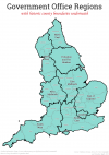
Namely, how would you divide up England into regions? Would you use the same as the official Government regions, or something else?
I have an interest in geography so for me, that would play a part as well as considering what large town or city is the natural 'go to' location for a place.
So, starting in the southeast:
The South East - would be east of the government definition, covering Kent, East Sussex, Surrey and those parts of West Sussex which look to Brighton more than they do Portsmouth - so perhaps from the Arun Valley eastwards
The Central South - as someone who has lived in this area most of my life, I feel there is a Central South identity separate from the SE or SW. It's basically the area which would look to Southampton, Portsmouth or Reading as the local commercial centres, rather than London or Brighton. So Hampshire and the Isle of Wight for certain, as well as the extreme west of West Sussex (Chichester, Midhurst, Petworth), south-eastern Wiltshire (SE of the chalk escarpment above Westbury and including all of Salisbury Plain), and most of Dorset, except those parts northwest of Cranborne Chase - again the chalk escarpment of the north Dorset downs is a barrier in my mind. Also much of Berkshire except perhaps the Bracknell and Slough areas, which would be part of the southeast, and far southern Oxfordshire (Henley area).
The South West - looks variously to Bristol, Exeter or Plymouth. All of Cornwall, Devon and Somerset, as well as the former county of Avon. Those parts of Wiltshire and Dorset northwest of the chalk escarpment, and far-west Dorset also (Bridport area). Dominated by dairy farming with less arable land.
The Oxford-Cotswold region - essentially has Oxford as the main commercial/cultural centre. Notable for the golden-coloured stone of Cotswold buildings, so basically all of Gloucestershire east of the M5 (including Cheltenham even though that's beyond the escarpment) as well as much of Oxfordshire, southeast Worcestershire and southwest Warwickshire.
The Marches - essentially the Welsh border region, beyond the Cotswold escarpment and characterised by higher hills than is present further southeast. Shropshire, Herefordshire, south-western Worcestershire and the Forest of Dean area of Gloucestershire.
The West Midlands - basically the area which looks to Birmingham. Close in definition to the 'official' one but some of Worcs and Warwickshire lost to the Marches or Oxford-Cotswold.
The East Midlands - very similar to the official definition but with the Dark Peak in the North West instead, as to me it seems highly 'northern' in character
The North West - similar to the official definition but minus Cumbria which seems separate to me,remote from the large cities of the NW. So Cheshire, Lancashire, Gtr Manchester, Merseyside, and the Dark Peak area of Derbyshire.
The 'United Counties' or 'M1 country'. Struggling to find a good name for this so will borrow either the previously-dominant bus company of the area or the local motorway. Basically the 'in-between' area of Herts, Bucks, Beds and Northants which seems to be too far west for East Anglia, too far south for the Midlands, and too far east for Oxford-Cotswolds.
East Anglia - much as the standard definition minus the areas mentioned above.
The East - Lincolnshire and east Nottinghamshire.
Yorkshire - big enough to be a region in itself
The North East - Tyne and Wear, Durham and Northumberland (east of the Pennine watershed)
Cumbria, together with any parts of northwest Yorkshire or west Durham which are west of the Pennine watershed.
Anyway, plenty of flaws I'm sure, and I am more famiilar with some of these areas than others - but would be interesting to see what people's thoughts on this are...