High Dyke
Established Member
I didn't really decide until the day.Nice photos! Shame I didn't know that you were coming....I could have bought you a pint or a coffee.
I didn't really decide until the day.Nice photos! Shame I didn't know that you were coming....I could have bought you a pint or a coffee.


Great photos! My wife and I nearly bought the half-timbered station house at Gargrave many years ago, but it all went horribly wrong.Decent day for a walk from Gargrave to Skipton, along the Leeds and Liverpool canal on Thursday.

 www.richardgower.com
Significance: High point of the island of Guernsey, Channel Islands
Elevation: 111 m
Route Start / End: car park in front of Guernsey Airport Terminal building
Route Stats: Approx 2 metres walk up the grassy bank between the car-park and the main road, 1 m elevation!
Somebody else has recommended a walk round the Anderson boat lift. Is it accessible by public transport?Had an excellent 9-mile walk around the attractive village of Great Budworth Cheshire, from the Anderton Boat Lift, with Southport Ramblers today. The first-time leader did a great job. Also did a good recce last Wednesday, getting the 0705 train from Southport, catching good connections at Oxford Road and Piccadilly to Hathersage, where I walked first to Grindleford station, then up Padley Gorge and along the valley of the Burbage Brook to Upper Burbage Bridge, then back by the Fiddler's Elbow, Mitchell Field and Scraperlow to Hathersage. The anytime short return from SOP to Hathersage with a railcard was only £14.10, excellent value.
It looks like this bus service stops close by. Found on OpenStreetMap.Somebody else has recommended a walk round the Anderson boat lift. Is it accessible by public transport?
9, 9A
Warrington - Northwich
That's good, it's on my list for a GM Wayfarer day at some point, not sure when.Meanwhile, not too far away, had a walk along the disused railway between Warrington and Altrincham with some other forum members today, which was enjoyable; and unlike some disused railway walks, was remarkably litter-free.
I didn't get there by bus, but I did see a bus passing near the village. I believe it was from Warrington.Somebody else has recommended a walk round the Anderson boat lift. Is it accessible by public transport?
Meanwhile, not too far away, had a walk along the disused railway between Warrington and Altrincham with some other forum members today, which was enjoyable; and unlike some disused railway walks, was remarkably litter-free.
I did that linear park with my first cousin once removed who lives in Rainford, and we enjoyed it; there is a café nearby called Bridge Farm which is a good place for a snack. Cousin Jackie recommended the sausage and egg sandwich.I had a gentle walk of the Rainford linear park today with some friends, runs along the old railway (St Helens and Runcorn Gap Railway) via the village and to an industrial park, where we ended up at a bus stop on the Rainford bypass for a bus to St Helens. Earlier in the morning I did a random loop South of Crewe towards Basford, a mix of roads and a footpath including a foot crossing of the Alsager line.
That's good, it's on my list for a GM Wayfarer day at some point, not sure when.
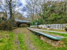
I walked the Brampton Valley Way in 2021 on a very hot day! A torch is definitely needed for the two tunnels.Another disused railway route for me, with the Brampton Valley Way along the former Northampton - Market Harborough line. 18 and a half miles in total from the railway station at Northampton to the bus stop on the square in Market Harborough (where I caught the X7 back to Northampton, making use of the £2 fare scheme).
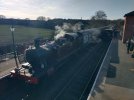
Once I gained access to the former railway route a couple miles north of Northampton station (nearly getting unstuck due to a flooded path with the bridge underneath the railway), mix of surfaces although due to the volume of rain (and snow) the path was muddy in places. Path runs alongside the heritage Northampton & Lampost railway with track renewals taking place. Vast majority was off-road with some road crossings, plus had two short unlit tunnels which slowed me down due to the path condition. Very rural in places, but sadly most evidence of the old stations have gone (no old platforms with info boards like I've come across on other railway paths).
Around 6 hours in total with little comfort/water/photo breaks.@Kite159 , that sounds a good route I’d like to try. How long did it take, as it’s not the easiest route from Sheffield to Northampton by train?
I agree with you about information boards (or lack of them). I love reading them, especially if they have old photos.